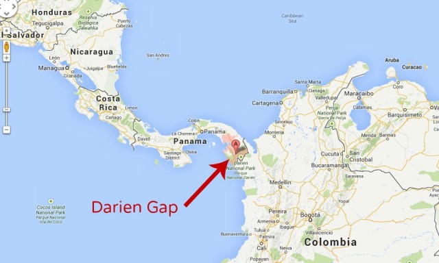
Darien Gap
STRADDLING THE BORDER of the republics of PANAMA and COLOMBIA, the Darien Gap is home to one of the least exploited and most diverse ecosystems in the world. Flanked by the PACIFIC OCEAN to the north and west and the CARIBBEAN SEA to the east, the area includes two national parks, Darien National Park in Panama and Los Katios National Park in Colombia. The area is 30 mi or 50 km wide, from the North Pacific Ocean to the Caribbean Sea, and 54 mi or 84 km in length, when measuring from the terminus city of Yarviza in Panama to Lomas Aisiadas in Colombia. The Darien Gap harbors varying landforms, from swamplands on the Colombian side to the mountainous rainforests with its tallest peak, Cerro Tacarcuna (standing at 5,535 ft or 1,845 m), on the Panamanian side. With more than 3 million acres of wilderness, the ecosystem found within is one of the most hotly contested, a political and environmental quagmire.
The Pan-American Highway, stretching approximately 16,000 miles or 26,000 km from ALASKA in the UNITED STATES to the Tierra del Fuego region of CHILE in South America, is broken only by the natural barrier of the Darien Gap. Initial plans to construct a road through the Darien Gap commenced in 1923 at the Fifth International Conference of American States. One of the primary reasons for the road is that through its completion, trade between North and Central America and South America would be more efficient with less reliance on the Panama Canal as the primary thoroughfare. Past opponents conferred that the spread of aftosa, or commonly known as foot-andmouth disease, would possibly be spread from the cattle of Colombia to Central and North America if the road were built.
In 1991, the U.S. Department of Agriculture proclaimed this threat to be extinct. Road construction began in 1971 and lasted until 1974, when further construction was halted due to environmental concerns. During that time period, part of the area was officially put under protection through decree no. 84 for the Alto Darien Protection Forest. Since that time, the area was designated as a World Heritage Site as well as a United Nations-designated Man and Biosphere Reserve. The area is home to two major tribes and several smaller ones. The subsistence agricultural lifestyle of the Chocos (both Emberas and Vainanas) and the Kunas is threatened, as it will be a potential loss of their land and culture if the road through the Darien Gap comes to fruition.
The route has been fully surveyed and partially completed, yet the political, economic, and environmental issues surrounding its construction are the true barriers to its completion. The approximate costs for completion would be approximately $200 million. Effective lobbying by environmental and indigenous groups, costs associated with the road infrastructure, governmental bureaucracy, and the de facto control of the area by Colombian rebel groups have left the fate of the remaining 54 mi or 84 km of road in limbo. Widely publicized accounts of civilian kidnappings, drug-smuggling anarchy, and the controlling activities of Colombian rebel groups have made this area one of the most dangerous in the world.