grid/graticule
THE EARTH IS NOT spherical but rather an ellipsoidal shape where the north and south poles are flattened and the equator bulges. This unique shape is called a geoid. In order to uniquely locate features on the Earth's surface, a reference system is required. An imaginary network of lines called a grid or graticule is superimposed on the Earth to serve this purpose.
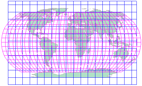
Although the terms grid and graticule are used synonymously, there is a subtle technical difference in their meaning. A graticule is a referencing system tied directly to the Earth's ellipsoidal shape. On the other hand, a grid is a network of perpendicular lines, much like graph paper, superimposed on a flat paper map to provide relative referencing from some fixed point as origin.
The graticule is composed of longitude lines (meridians), which run north-south, and LATITUDE lines (parallels), which run east-west. The longitude lines converge at the North Pole in the Northern Hemisphere, and at the South Pole in the Southern Hemisphere. The equator divides the Earth into two hemispheres. All meridians and the equator are great circles since they can form planes that cut the surface and pass through the center of the Earth. Small circles such as latitude lines form a plane that cuts the surface but does not pass through the center of the Earth. In this system of reference, geographic coordinates are measured in units of angular degrees.
There are 360 degrees of longitude around the equator, with each meridian numbered from 0 to 180 degrees east and west such that the 180 degree meridian is on the opposite side of the Earth from Greenwich, England. There are 180 degrees of latitude from pole to pole, with the equator being 0 degrees and the north and south poles being 90 degrees. Each degree is divided into 60 minutes (60') and each minute is divided into 60 seconds (60”). The north-south line is called the prime meridian, which has been arbitrarily set to pass through the Royal Observatory in Greenwich, England. The longitude is measured as the angle between the point, the center of the Earth, and the prime meridian at the same latitude. West is positive and east is negative, meeting at 180 degrees at the international dateline. The east-west line follows the equator and is midway between the north and south poles. Degrees of latitude are measured as the angle between the point on the surface, the center of the Earth, and a point on the equator at the same longitude. In this graticule reference system, the size of the cells is largest at the equator and the zones are square. At the poles, the zones are smallest and triangular.
When the three-dimensional Earth is projected unto a flat paper map there are distortions in distance, area, and direction, and the projection process attempts to minimize these distortions when transferring the curved Earth to the flat map. The projection process affects both the graticule and Earth features. On the flat map there is no natural reference point, but one can be defined using an arbitrary system of coordinates. A grid of intersecting parallel and perpendicular lines is placed over the projected map such that the origin of the grid lines fall on a point of interest on the map. This arrangement is called a grid reference system, and every point on the flat map can be located with a unique X and Y coordinate. Usually, the X coordinates are referred to as eastings and the Y coordinate as northings. An example of a grid system is the Universal Transverse Mercator (UTM) system.
Graticules are always expressed in geographic coordinates (latitude and longitude) while grids are expressed in some locally defined X and Y coordinate system. In projected coordinate systems, graticules will appear as curved lines (when necessary) to follow the curved form of the meridians of longitude or parallels of latitude in the projection. Grids, however, will always appear as an arrangement of horizontal and vertical straight lines.