Amu Darya
THE AMU DARYA has served as a bridge between cultures for several millennia. A river that flows straight across one of the harshest deserts in the world, it has served as a natural highway for migrants and invaders from Central Asia to South Asia and the MIDDLE EAST, as well as a boundary for the empires established by these same invaders. The Amu Darya starts high in the HINDU KUSH mountains at the boundaries of AFGHANISTAN, KASHMIR, CHINA, and TAJIKISTAN, at an elevation of 16,170 ft (4,900 m). From there, it descends rapidly to the great central Asian lowlands, which are mostly covered by the Kara Kum and Kyzyl Kum deserts. Much of the river's water is lost to evaporation and irrigation, so water levels are actually lowest when it finally reaches its mouth in a large delta on the ARAL SEA, 1,500 mi (2,419 km) later.
The river was known as the Oxus (or the River Styx, River of Hades) to the ancient Greeks and formed the northern extremity of the lands conquered by Alexander the Great in the 4th century B.C.E. The lands that now form UZBEKISTAN and KAZAKHSTAN were thus known for much of their history as Trans-Oxiana. The river's current name comes from the ancient city of Amulya (near Chardzhou), plus darya (Turkic for “river”). Irrigation has long been vital to cities in the region, cities whose importance was heightened as stops on the SILK ROAD from Persia to China. Important sultanates grew up around the cities of Khiva, near the delta, and Bukhara further upstream, near the confluence of the deserts and the foothills of the great mountains to the east. Fertile desert soils, watered by the Amu Darya and bathed in unending sunshine, were famous for their production of extra sweet fruits, notably apricots, dates, and melons, and aromatic plants such as lavender and sage. Imperial Russian and later Soviet administrations increased the development of irrigation of the Amu Darya valley, making Uzbekistan into a leading producer of cotton, but have also caused the ARAL SEA to shrink to in size. At some times during low water, the Amu Darya does not even reach the Aral at all.
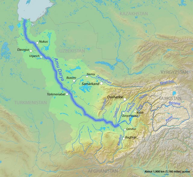
The Amu Darya basin drains 208,558 square mi (534,764 square km), including most of Tajikistan, northern Afghanistan, and a small area of south KYRGYZSTAN. Seventy-two percent of the basin is arid, while 22 percent is cropland through irrigation. Nearly from its source in the Wakhan panhandle of northeastern Afghanistan, the river serves as the border between that country and Tajikistan, and is fed by several swiftmoving mountain tributaries from both countries.
The river is called the Vakhan Darya until it is joined by the largest of these tributaries, the Vakhsh, from Tajikistan, then assumes the name Amu Darya. At its emergence from the foothills of these great mountains, the river valley becomes the border between Uzbekistan and Turkmenistan, though much of the river itself lies within the latter until the city of Chardzhou, and within the former from Khiva to the delta. In this segment, the river is slow and wide and receives no tributaries at all and very little rain, thus losing approximately 25 percent of its volume before it reaches the Aral Sea.
Chardzhou, the largest city in northeastern Turkmenistan, marks the boundary between semidesert and desert; from this point on, the sands of the Kara Kum approach the river directly and add considerably to the already heavy load of silt, sand, and mud being carried by the river from the mountains. The Amu Darya is considered the most heavily silted river in the world, with its high volume of suspended material giving it its characteristic murky yellow coloring.
The eastern parts of the river in Turkestan have natural gas reserves. Transportation from this interior is linked to Turkestan's capital and ports on the CASPIAN SEA by the Kara Kum Canal and a railroad link that crosses the Amu Darya in an impressive mile-long bridge at Chardzhou. The Amu Darya itself is little used for commercial traffic, since the Aral Sea connects with no other bodies of water, and the river itself is filled with constantly shifting sandbars and a variety of meanders.