Anatolian Plateau
THE ANATOLIAN PLATEAU is the central upland region of the ancient region of Anatolia, today's TURKEY. The plateau is hemmed in by two parallel mountain ranges, the Taurus to the south, along the Mediterranean coast, and the Pontic Mountains to the north, along the coast of the BLACK SEA. Anatolia has served as a bridge between the civilizations of Europe and Asia for thousands of years, with waves of different cultures taking advantage of this central position and establishing cities and empires on the plateau. Site of the first large empire of the Western world, the Hittite, dating from the 15th century B.C.E., the plateau was later given its modern name Anatolia, or “rising sun”by the Greeks looking eastward.
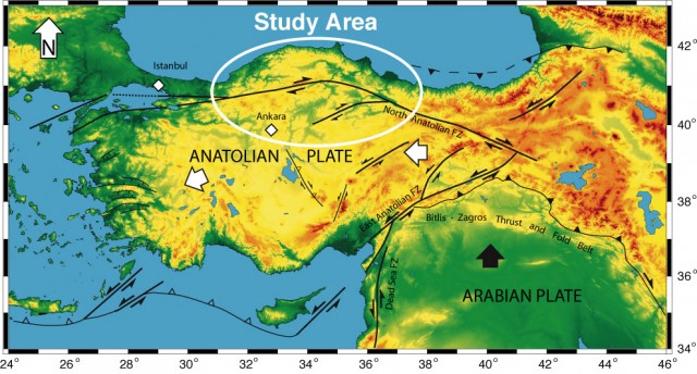
Most of the Anatolian Plateau lies at elevations above 1,640 ft (500 m). This mountainous region lies at the center of the Arabian, African, Eurasian, Aegean and Turkish tectonic plates: the resulting landscape is dotted with volcanoes (today extinct) and regular earthquakes. The central plateau is composed of uplifted blocks and downfolded troughs filled by shallow salt lakes. Elevations on the plateau itself range from 1,980 to 3,960 ft (600 to 1,200 m). This increases to the east, where the two mountain ranges, the Taurus and Pontic, join to form the eastern highlands (including the highest mountain peaks in Turkey such as Mount Ararat).
The two largest basins on the plateau are the Konya Ovasi and the basin occupied by Tuz Golu (Salt Lake)—both drain large inland areas and have no external outlet. Other parts of the plateau are drained either by short rivers that flow south into the Mediterranean, or by several larger rivers (notably the Halys and the Sakarya) that drain northward into the Black Sea. Two extinct VOLCANOES, Erciyes and Hasan, left behind lava flows that have eroded over time to form spectacular landscapes of rock cones and capped pinnacles in Goreme, near Nevsehir. The earth in these areas is colored a variety of grays and reds.
The plateau is mostly dry with a mixture of dark and desert soils. Summers here are hotter and drier than in the rest of Anatolia, but also colder and wetter in the winter, with temperatures averaging freezing and frequent heavy snows. The plateau is mostly covered in STEPPE, with short grasses, bushes and stunted willow trees.
Wooded areas are confined to the northwest and northeast, and cultivation (wheat and barley) is restricted to narrow river valleys. IRRIGATION is practiced where water is available, but a deeply entrenched river course makes it difficult for engineers to raise the water to the surrounding agricultural land. Summer dust storms, locusts, extreme heat, and occasional droughts limit agricultural output. Some areas are cultivated with orchards and vineyards, but for the most part the land is used for grazing. Some larger animals live in the highlands (wolf, fox, bear), but the ubiquitous domesticated Angora goat is everywhere. Stock raising is important and overgrazing has also caused some erosion problems.
The capital of the republic of Turkey was moved to the Anatolian Plateau in 1923. The city of Ankara was chosen as the capital of the new state to remove it from connotations of the imperial capital at Istanbul and to place it in the geographic center of the country. The region is also home to ancient ruins of the Hittite civilization at Catal Huyuk and to the underground cities of Kaymakli and Derinkuyu, ancient refuges for early Christians. Konya (Roman Iconium) is the region's major cultural center, known for its mosques and “whirling dervishes.”