Bodies of Water and Landforms
A HUMAN PERSPECTIVE In July 1971, astronaut James Irwin was lifted into space on the Apollo 15 mission. As he circled the earth, he was deeply moved by the beauty of our planet. Later he wrote this: Anyone passing through our solar system would be attracted to the blue planet. They would know that the blue color indicated water on Earth. They would know that where there is water there is probably life. They might try to meet us. We, the blue planet, stand out as a beacon to all.
The earth is unlike any other observable planet in our solar system. It is a living planet.
Bodies of Water
Without both freshwater and saltwater, life on this planet would be impossible. Water not only supports plants and animals, it helps distribute heat on the earth.
OCEANS AND SEAS
The ocean is an interconnected body of salt water that covers about 71 percent of our planet. It covers a little more than 60 percent of the Northern Hemisphere and about 81 percent of the Southern Hemisphere. Even though it is one ocean, geographers divide it into four main parts: the Atlantic Ocean, the Pacific Ocean, the Indian Ocean, and the Arctic Ocean, which is sometimes considered part of the Atlantic. The largest of the oceans is the Pacific. The waters near Antarctica are sometimes called the Southern Ocean.
OCEAN MOTION
The salty water of the ocean circulates through three basic motions: currents, waves, and tides. Currents act like rivers flowing through the ocean. Waves are swells or ridges produced by winds. Tides are the regular rises and falls of the ocean created by the gravitational pull of the moon or the sun. The motion of the ocean helps distribute heat on the planet. Winds blow over the ocean and are either heated or cooled by the water. When the winds eventually blow over the land, they moderate the temperature of the air over the land.
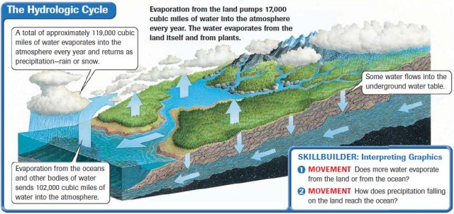
HYDROLOGIC CYCLE
The hydrologic cycle is the continous circulation of water between the atmosphere, the oceans, and the earth. As you can see in the diagram above, water evaporates into the atmosphere from the surface of the oceans, other bodies of water, and from plants. The water exists in the atmosphere as vapor. Eventually, the vapor cools, condenses, and falls to earth as precipitation—rain or snow. The water soaks into the ground, evaporates to the atmosphere, or flows into rivers to be recycled.
LAKES, RIVERS, AND STREAMS
Lakes hold more than 95 percent of all the earth's fresh water supply. The largest freshwater lake is Lake Baikal in Russia. Its volume of water equals 18 percent of all freshwater on earth. Freshwater lakes like the Great Lakes of North America are the result of glacial action thousands of years ago. Saltwater lakes result from changes in the earth's surface that cut off outlets to the sea. Saltwater lakes are created when creeks and rivers carry salts into a lake, and there is no outlet to carry the salt away. The Great Salt Lake in Utah is the remnant of a large freshwater lake—Lake Bonneville. Its water outflows were cut off, causing the remaining water to become more salty as the water evaporated. The largest saltwater lake is the Caspian Sea in Western Asia.
Rivers and streams flow through channels and move water to or from larger bodies of water. Rivers and streams connect into drainage systems that work like the branches of a tree, with smaller branches, called tributaries, feeding into larger and larger ones. Geographers call an area drained by a major river and its tributaries a drainage basin.
GROUND WATER
Some water on the surface of the earth is held by the soil, and some flows into the pores of the rock below the soil. The water held in the pores of rock is called ground water. The level at which the rock is saturated marks the rim of the water table. The water table can rise or fall depending on the amount of precipitation in the region and on the amount of water pumped out of the ground.
Landforms
Landforms are naturally formed features on the surface of the earth. The diagram on pages 34–35 shows the different kinds of landforms.
OCEANIC LANDFORMS
The sea floor has landforms similar to those above water. The earth's surface from the edge of a continent to the deep part of the ocean is called the continental shelf. The floor of the ocean has ridges, valleys, canyons, and plains. Ridges mark places where new crust is being formed on the edges of the tectonic plates. Mountain chains similar to those on the continents themselves cover parts of the ocean floor. The longest continuous range is the Mid-Atlantic Ridge, which extends for thousands of miles north to south through the middle of the Atlantic Ocean. Islands dot the ocean surface. Islands can be formed by volcanic action, deposits of sand, or deposits of coral skeletons.
CONTINENTAL LANDFORMS
To understand the types of landforms, study the illustration on pages 34–35. The major geographic feature that separates one type of landform from another is relief. Relief is the difference in elevation of a landform from its lowest point to its highest point. There are four categories of relief: mountains, hills, plains, and plateaus. A mountain, for instance, has great relief compared with a plain, which displays very little difference between its high and low points.
Topography is the combination of the surface shape and composition of the landforms and their distribution in a region. A topographic map shows the landforms with their vertical dimensions and their relationship to other landforms.
In the next section, you will learn how internal forces of the earth help to build and change the landforms on the earth—and how those forces affect humans.