Borneo
THE ISLAND OF BORNEO is the largest island of the Malay archipelago and the third-largest island in the world (after GREENLAND and PAPUA-NEW GUINEA), covering 287,420 square mi (736,974 square km). It is also one of the least explored places on Earth and retains much of the mystery for today's tourists that it did for anthropologists and adventurers of the 19th century. Borneo is not a single political unit; rather, it is divided among three countries: 72 percent of the island, known as Kalimantan, is a province of INDONESIA. The rest forms the two eastern provinces of MALAYSIA, Sabah and Sarawak, plus the small independent sultanate of BRUNEI.
Unlike most of its island neighbors, Borneo is not entirely volcanic in origin, but formed of ancient igneous rock. It is seen more as an extension of the continental landmass of Southeast Asia, separated only by the Sunda Sea, which is very shallow (656 ft or 200 m) and was probably dry land in the geologically recent past. This is in contrast to the deep plunges of the waters to the east and south of the island, the Sulu and Celebes seas, and the Selat Makasar.
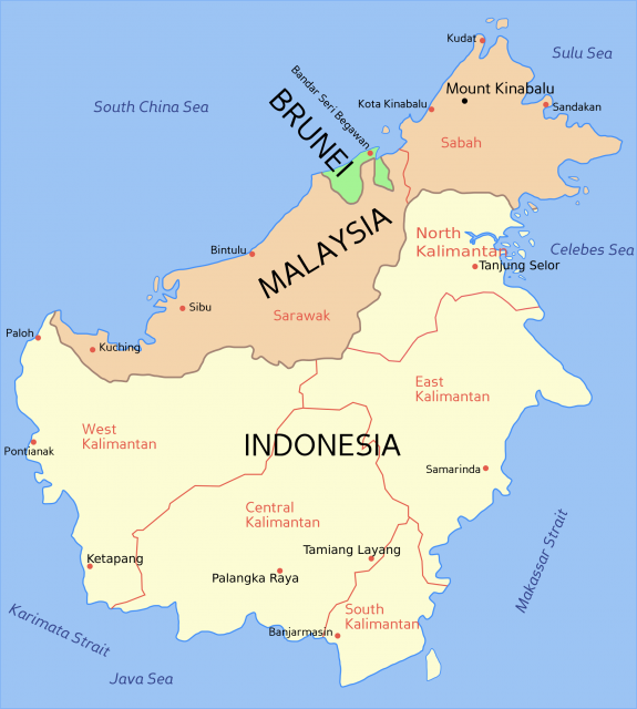
Borneo is crossed by two main mountain chains, which roughly divide the island into four watersheds. Three of these cover Kalimantan, while the fourth, that of the northwest, waters Sabah, Sarawak, and Brunei. The main range, like a backbone, crosses the island diagonally from southwest to northeast and consists of the Kapuas and Iran ranges—which form the boundary between the Indonesian and Malaysian parts of the island—continue in the south as the Schwaner range. These ranges have several peaks over 6,600 ft (2,000 m), but the highest mountain on the island (and in Southeast Asia), Kinabalu (13,533 ft or 4,101 m), stands on its own at the far northern point of the island. The volcanic Kinabalu is one of the leading spots in the region for tourists, drawn to its hot mineral springs and exotic wildlife, including the Rafflesia, the largest flower in the world (up to 66 in or 170 cm in diameter).
The coasts are almost entirely alluvial and swampy, especially in the south and southeast. This area is one of the best watered in the world, with frequent rains and numerous rivers and streams. But most are obstructed by mud and vegetation, and navigation for larger vessels is hindered by swamps at most river mouths, spreading across vast DELTAs, some reaching up to 70 mi (113 km) across. During the rainy season, for example, the Barito River in the southeast covers a delta of roughly 11,000 square mi (28,000 square km).
The equator cuts directly across the island, and its vegetation reflects this geographic position. Most of the area is covered with thick forests and dense vegetation. The forests contain valuable tropical hardwoods like teak, ebony, and sandalwood, the best camphor in Asia (a tree resin used to make medicines), and spices such as nutmeg, ginger, cinnamon, clove, and pepper. The forests also contain many large wild animals, such as the Asian elephant, gibbon, tapir, the giant python (which grow up to 20 ft), and the so-called man of the forest, the orangutan. Deforestation is a serious problem, however, causing both erosion and loss of habitat for these increasingly rare animals. Especially bad in Kalimantan, out-of-control forest fires have burned continuously since 1983, destroying millions of acres. These fires are sometimes set deliberately by farmers or loggers clearing small plots, but they are fueled by underground coal deposits, creating searing temperatures that roast the subsoil.
Borneo is also incredibly rich in minerals, including gold, coal, copper, platinum, and diamonds. There is a significant amount of petroleum on the east coast near Tarakan and Balikpapan and on the west coast near Miri (Sarawak) and Seria (Brunei). This wealth of natural resources is a source of economic strength for Brunei and eastern Malaysia, and a source of potential disintegration for Indonesia, as the outer islands seek greater autonomy from overcrowded and proportionately resource-poor JAVA.
Most of the population clusters along Borneo's rivers, as the coasts are too swampy and the interior too rugged. The indigenous people, known collectively as Dayaks, are divided into numerous tribes and live in various degrees of contact with other, nonindigenous peoples. Some were known as recently as the 1970s to practice ritual headhunting, but the practice has officially ceased.
Malayan people have had settlements and kingdoms on Borneo from about the 13th century, roughly the same time as the arrival of the third main group who populate Borneo, the Chinese, who dominated trade in the region for centuries. Dutch and British trading companies vied for dominance in the 18th and 19th centuries, with the Dutch ultimately controlling the southern three-fourths of the island, and the British controlling the north, including the sultanate of Brunei (a protectorate from 1888), the territory of the “WhiteRajah,” James Brooke (Sarawak), and the world's last sovereign corporate-run state, British North Borneo (Sabah, governed until 1946 by the British North Borneo Provisional Association, Ltd.).
Rubber plantations were established by the British and the Dutch, but it was palm oil that became the backbone of colonial export, used to produce things like margarine and soap. Dutch Borneo became part of the independent Republic of Indonesia in 1949, while Sabah and Sarawak joined with Malaya to form Malaysia in 1957. Brunei remained a protected British state until 1984. Malays now form a larger percentage of the population on account of the exodus of large numbers of Chinese from both Malaysia and Indonesia in the face of growing xenophobia and Islamicism.