Canada
Area 3,850,000 square mi (9,984,670 square km)
Capital Ottawa
Population 35.54 million 2014
Highest Point 19,550 ft (5,959 m)
Lowest Point 0 m
GDP $1.787 trillion 2014
Primary Natural Resources iron ore, nickel, zinc, copper, gold.
CANADA ENCOMPASSES the second-largest land area of any country after RUSSIA. Like its southern neighbor, the UNITED STATES, Canada's terrain varies quite dramatically and is divided into multiple geographical areas.
The CANADIAN SHIELD, which is the largest geographical area, encompasses half the country and centers on Hudson Bay. This horseshoe- shaped region reaches northward from the U.S. border and covers the area from the Gulf of St. Lawrence in the east, south to the Great Lakes, and west to the Great Slave Lake in the province of Vancouver. The Canadian Shield was carved during the last Ice Age, when glaciers moved across the land, scraping away the soil, damming rivers, and creating lakes. Its rivers are the heart of Canada's hydropower industry.
The southeastern region of Canada consists of lowlands, bordered by the Great Lakes: Lake MICHIGAN, Lake SUPERIOR, Lake ERIE, and Lake ONTARIO. It is segmented by the ST. LAWRENCE RIVER, which is an important shipping lane. The St. Lawrence River flows downward toward the ocean from the Great Lakes, which are above sea level. A series of locks help to move the ships upstream. Montreal sits at what is the head of navigation on the river, the point at which the ships can go no further due to rapids or waterfalls.
ERODED MOUNTAINS
Further north and east, the APPALACHIAN MOUNTAINS extend north from the United States. This mountain range is a chain of older, well-eroded mountains that were created by glacial activity. The eastern region of Canada is heavily forested. The tree line or boreal forest consists of coniferous (evergreen) trees and extends across the Ungava Peninsula to the lower Mackenzie Valley and ALASKA. North of this area, the poor soil quality supports little vegetation beyond hardy, shallow-rooted tundra plants such as lichens and mosses. Because of the cold temperatures, the soil below the top layer of soil is permanently frozen and does not thaw even in the summer months.
South-central Canada consists of rich, flat farmland and lakes. To the west, the plains give way to PLATEAUs and river channels that were carved by glacial activity during the last Ice Age. Western Canada is home to the Canadian Cordillera, a system of rugged mountains that include the St. Elias, Mackenzie, and Rocky Mountain ranges.
Canada's highest mountain, Mount Logan (19,550 ft or 5,959 m), is a part of the St. Elias Mountain Range. The western coast consists of dense forests and mountains that are the source for three of Canada's major rivers: the Columbia, the Yukon, and the Frasier. These rivers serve as important parts of Canada's hydropower industry. The western port of Vancouver, Canada's third-largest city, serves as Canada's main port for the exportation of wheat, coal, and lumber to Asia. Northern Canada consists largely of year-round permafrost and frozen tundra. Due to the extreme temperatures in the winter, less than 1 percent of Canada's population lives in the northern territories and many who live in the north are Inuit Amerindian.
CLIMATE
Canada has four distinctive seasons. The timing of each of these seasons changes, according to latitude. The Canadian CLIMATE is subarctic throughout most of the country. On average, temperatures are cool in the summer and sub-freezing during the winter, with the average temperature hanging below 0 degrees F and C. In northern Canada, winter begins in August and runs through March, and daylight is extremely limited. In the Arctic regions of northern Canada, there is no sunlight for six months of the year.
In the southern part of the country, summers and winters are much more temperate. Temperatures can reach the lower 80s F (upper 20s C) during the summers. The mildest winters occur in the southeast and along the western coast.
The east and west coasts tend to be wet year-round, and the western coast experiences heavy seasonal rains during the winter months. The movement of air across the plains to the Canadian ROCKY MOUNTAINS causes air flow patterns that can produce cyclic storms to the east of the mountains during the winter. The Canadian Central Plains themselves are generally quite arid yearround, although thunderstorms mitigate some of the dryness during the summer.
ENVIRONMENT
Canada's mining industries, as well as coal-burning and vehicle emissions, have caused significant problems with air pollution, water contamination in the oceans, and acid rain. The country is also prone to several environmental hazards. The west coast of Canada (mostly British Columbia), is a part of the Pacific Rim, or RING OF FIRE.
The Ring of Fire is marked by its unusual number of volcanoes. The west coast of the Canadian province of British Columbia and the southern part of the Yukon include many volcanoes. There have been no recent eruptions, but many of these volcanoes remain active today. Due to its location along the Ring of Fire, Canada's western coast is also vulnerable to tsunami activity, which may result from seismic or volcanic activity elsewhere in the Pacific.
Canada also records approximately 9,000 forest fires throughout the country every summer. Most of these fires are caused by lightning strikes.
GOVERNMENT
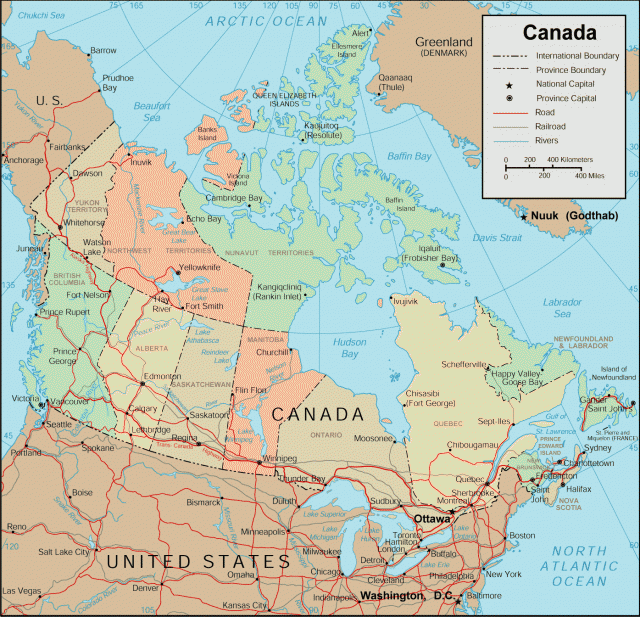
The seat of the Canadian national government is located in Ottawa, a city that is situated in the southern part of the province of Ontario. Canada is sub-divided into 10 administrative provinces (the capitals are in parentheses): Newfoundland (St. John's), Nova Scotia (Halifax), New Brunswick (Fredericton), Prince Edward Island (Charlottetown), Quebec (Montreal), Alberta (Edmonton), Saskatchewan (Regina), British Columbia (Victoria), Ontario (Toronto), and Manitoba (Winnipeg). Provincial governments mirror the national government. Their responsibilities include civil law, local taxation, land management, local trade, health, welfare, and education.
Newfoundland, Prince Edward Island, Nova Scotiaand New Brunswick, which are all peninsulas, make up what is known as the Atlantic Provinces. Halifax is the largest city, and serves as an important port, as it remains free of ice year-round, making it easily accessible to ships in the winter, when many other ports are iced in. The bulk of the population of the Atlantic Provinces lives along the coast, and many make their livelihoods from the sea.
Since the 1960s, there has been a separatist movement within Quebec, where the majority of the population is of French ancestry rather than the Anglican ancestry shared by most of the population. Thus far, any attempts to secede from Canada have proven unsuccessful. In addition to its 10 administrative provinces, Canada has three dependent territories. The Yukon and Northwest territories, which are very sparsely populated, are administered by the federal government. Nunavut became the newest territory of Canada on April 1, 1999, when the Northwest Territories was divided into two parts. The part to the east of the dividing line became Nunavut, whereas the part to the west became a new territory that retained the name Northwest Territories.
ECONOMY
The Canadian economy is heavily dependent on trade, particularly with the United States. The NORTH AMERICAN FREE TRADE AGREEMENT (NAFTA) has permitted relatively unrestricted trade between Canada, the United States, and MEXICO. Dominant industries include mining, forestry, agriculture, and fishing. Most of the agriculture occurs in the southern part of the country, because of short growing seasons further north. Wheat is the most predominant cash crop, although corn, soybeans, and tobacco are also significant crops. In the western prairies, most agriculture consists of raising livestock, particularly sheep, cattle, and pigs.
Most of the fishing industry is centered along the east coast, around Labrador. However, there is some salmon fishing in the west. Also in the west, British Columbia is home to Canada's forest industry, where there is significant production of wood pulp and paper. The western part of the country is also home to Canada's primary mineral resources: oil, gas, and coal. Further east and north, the mining industry is focused on zinc, iron, nickel, copper, lead, uranium, and potash.
HISTORY
Like most of North America, Canada's first settlers are generally believed to have arrived across the Bering Strait from SIBERIA via a now-defunct land bridge approximately 10,000 to 30,000 years ago and disseminated throughout the continent. A second wave of settlers, who are the ancestors of the Inuit people, arrived around 4000 B.C.E.
The Vikings were the first Europeans to reach Canada, most notably Leif Eriksson and Thorfinn Karlsefni around 1000 C.E. The Vikings did not stay however, and the next Europeans did not arrive until Italian navigator John Cabot's expedition landed at Newfoundland in 1497. By the 16th century, French and English explorers, including Jacques Cartier and Samuel de Champlain, arrived and began to explore Canada's interior. Cartier gave Canada its name, following a misunderstanding regarding the Iroquois word for “village.” When Cartier asked the Iroquois the name of his location, they answered “Kanata.” Cartier and the other explorers who were with him began to refer to that location (now Quebec City) as “Kanata,” anglicizing it to “Canada.”
Canada remained a subject of exploration for those who hoped to find a northwest passage between the Atlantic and Pacific Oceans that might facilitate trade between Europe and Asia. Henry Hudson, who led the ship Discovery in 1610, was one of the earliest explorers who sought such a passage. Although Hudson was unsuccessful, his quest did lead to a charter to be commissioned by King Charles II of England in 1670. This charter granted Prince Rupert and 17 other men sole trading rights on all lands whose rivers drained into Hudson Bay, an area that encompassed nearly 40 percent of Canada. Rupert and the other men became known as the Governor and Company of Adventurers Trading into Hudson Bay. They are considered to be the first governors of the English colony. This early federal state included portions of what are now the Canadian provinces of Quebec, Nova Scotia, and New Brunswick.
The settlement of Canada occurred first in the east, along the Atlantic coast and Hudson Bay area. The French quickly colonized the region around the St. Lawrence River and the Great Lakes between Quebec and Montreal. The French settlers began a thriving fur trade, although conflicts over settlement rights grew between the French and English settlers. These conflicts culminated in the capture of Quebec and Montreal by British General James Wolfe. The tension was resolved, at least temporarily, by a treaty that was signed in Paris in 1763 that turned the lands over to the British.
Canada became even more of a British stronghold during the years of the American Revolutionary War, when British loyalists fled to Canada. Two distinct colonies, Upper and Lower Canada, were created by a constitutional act in 1791. Dissension led to an unsuccessful revolt in 1837, although political reform resulted, including the fusion of the two colonies.
In 1845, a second famous attempt to find a northwestern passage took place. Englishman Sir John Franklin took 128 men and two ships, the Terror and the Erebus. Franklin's mission was commissioned by Sir John Barrow, England's Secretary of the Admiralty. Franklin and crew were directed to sail through Lancaster Sound and Barrow Strait and to get as close as possible to the Bering Strait by traveling southwest. Franklin and company were last seen on July 26, 1845. By 1848, when no word had been received from the expedition, a small rescue mission of three teams was dispatched to search for them. None of the three teams was successful and neither Franklin nor any members of his crew was ever seen or heard from again.
The gold rushes of the 19th century served as important catalysts in the interest, acquisition, and settlement of what is now western Canada. Canada gained territory in the west in 1849, with the creation of the colony of Victoria, which is located on the island of Vancouver, off the coast of British Columbia. Canada expanded again in 1858 as the result of the gold rush, and British Columbia was added to the growing British colony. During this time period, Canada experienced an increasing population, including an influx of immigrants from other European countries, including Russia.
Until the cessation of slavery, Canada also served as a refuge for African-Americans who had escaped from slavery in the southern United States. Canada officially became the Dominion of Canada in 1867, under the British North America Act. The provinces of Quebec, Ontario, Nova Scotia, and New Brunswick were all added at this time.
A second gold rush occurred in the late 19th century, known as the Klondike Rush. Prospectors who had been working in the region of modern-day San Francisco, heard rumors of gold being discovered in the Yukon Territory. Thousands of would-be miners came pouring into the sleepy lumber mill town of Dawson City, which had been founded near the junctions of the Yukon and Klondike rivers by Joseph Ladue in 1896 and named after George M. Dawson, who had led a geographic survey of the Northwest Territories in 1887. The area remained busy with prospecting activities for approximately three years, after which the prospectors moved on when gold was discovered in Nome, ALASKA.
The later half of the 19th and early 20th century proved to be a time of accelerated geographic expansion for Canada. Although some of the expansions and geographic changes involved the redrawing of boundaries of existing western and eastern settlements, much of the expansion included additional territories in the northwest as well as the acquisition of lands that are now a part of central Canada. The government purchased the Northwest Territories from the Hudson Bay Companies in 1870. In the next 35 years, Manitoba (1870), Prince Edward Island (1873), the Yukon Territory (1898), and Saskatchewan and Alberta (both 1905) all joined the Dominion.
As in the United States, the geographic expansion of the European settlers proved to be problematic for the native peoples. Settlers encroached on native lands and destroyed the bison, which were an important food source and resource. Tensions flared and culminated in an armed uprising in the later half of the 19th century by the Metis, who were of French and native ancestry. The uprising was unsuccessful and Louis Riel, who led the uprising, was executed in 1885.
Britain granted increase autonomy to the Dominion in 1931, in recognition of its support for the Allies during World War I. Twenty-one years later, in 1982, Canada gained full control of its constitution. The Canadian Constitution replaced the British North America Act and guarantees such rights as freedom of religion, speech, association, and the press. Canada has remained geographically stable since this time.