What Are Heat and Temperature?
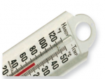
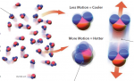
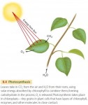
THE TERMS HEAT AND TEMPERATURE are used every day, but what do they actually mean? Temperature is a measure of the object's internal kinetic energy — the energy contained within molecules that are moving, and heat is thermal energy transferred from one object to another. Moving molecules drive many processes in the Earthocean-atmosphere system, such […]
What Is Energy and How Is It Transmitted?
THE TRANSMISSION OF ENERGY, and the interactions between energy and matter, define the character of our planet and control weather, climate, and the distribution of life, including humans. Here, we examine the fundamentals of energy, including what it is, where it comes from, and how it is moved from one place to another. What Is […]
What Is the Atmosphere?
A RELATIVELY THIN LAYER OF GAS — the atmosphere — surrounds Earth's surface. The atmosphere shields us from harmful high-energy rays from space, is the source of our weather and climate, and contains the oxygen, water vapor, and other gases on which all life depends. What is the character and composition of the atmosphere, and […]

Energy and Matter in the Atmosphere
TOPICS IN THIS CHAPTER What Is the Atmosphere? What Is Energy and How Is It Transmitted? What Are Heat and Temperature? What Is Latent Heat? What Is Electromagnetic Radiation? What Controls Wavelengths of Radiation? What Causes Changes in Insolation? Why Does Insolation Vary from Place to Place? Why Do We Have Seasons? What Controls When […]
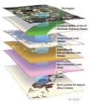
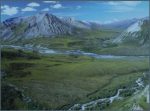
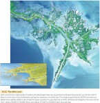
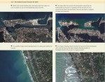
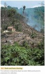
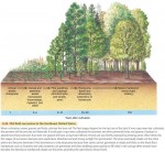
What Might Happen If This Location Is Deforested?
YOU HAVE BEEN EMPLOYED by a county planning commission. You are asked to assess any possible impacts of logging (removing trees) of a mountainside in the area under your jurisdiction. To address the problem, you rely on your broad perspective and skills in the use of maps, satellite-image interpretation, physical geographic principles, and the scientific method. […]
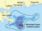
How Did Geographers Help in the 2010 Gulf of Mexico Oil-Spill Cleanup?
ON APRIL 20, 2010, an explosion on the Deepwater Horizon oil rig in the northern Gulf of Mexico killed 11 workers, injured 17 others, and initiated the most disastrous oil spill in U.S. history. For the next 86 days, oil gushed into the Gulf. This oil spill is an example of a complex problem with […]
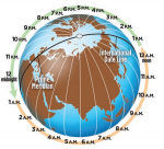
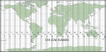
What Is the Role of Time in Geography?
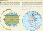
WE LIVE ON A GLOBE THAT ROTATES, causing locations on the surface to pass from day to night and back again. Not everyone witnesses sunrise at the same time, because the Sun rises at different times in different locations. Some ideas from geography, especially the concept of longitude, help us understand these differences and describe […]
How Do We Use GIS to Explore Spatial Issues?
MAPS ARE USED FOR REPORTING OBSERVATIONS and making interpretations from previously collected observations, and they can also be analyzed to create new maps. Maps created from aerial photographs, satellite imagery, and field observations can be stored in computer databases called geographic information systems (GIS), where a variety of information can then be combined quickly and […]
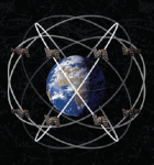
How Do We Use Global Positioning Systems and Remote Sensing?
THE GLOBAL POSITIONING SYSTEM GPS and remote sensing have greatly increased the accuracy of geographic field studies and given geographers new methods for performing geographic analyses. GPS helps geographers define spatial relationships among Earth's surface features, and a wide variety of remote sensing techniques help geographers define regional patterns and monitor changing environmental conditions. What […]
How Do We Use Maps and Photographs?
MAPS ARE AMONG OUR MOST IMPORTANT TOOLS for depicting and analyzing spatial information, whether we are interested in environmental issues or election results. Cartographers generate different kinds of maps that are designed to show Earth's landscape features, its weather and climate, and the distribution of plants, animals, or many other types of variables. Some cover […]
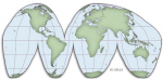
How Do Map Projections Influence the Portrayal of Spatial Data?
EARTH IS NOT FLAT, so a flat map cannot portray all locations accurately. An ideal map would preserve directions, distances, shapes, and areas, but it is not possible to preserve all four of these accurately. Instead, either the shape of features on a map, such as country outlines, is preserved or the area of features […]
What Are Some Other Coordinate Systems?
WE USE OTHER SYSTEMS, besides latitude and longitude, to describe location. These include the Universal Transverse Mercator (UTM) system, the State Plane Coordinate System (SPCS), and the Public Land Survey System (PLSS). Each is very useful for certain applications, and some are used to specify the location of real-estate properties appearing on legal documents associated […]
What Do Latitude and Longitude Indicate?
IMAGINE TRYING TO DESCRIBE the location of an “X” on a featureless sphere. What system would you devise to convey the location? If the sphere did not have any markings or seams, we would need to first establish a frame of reference — a place on the sphere from which to reference the location of […]
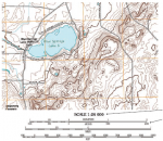
How Do We Depict Earth’s Surface?
EARTH'S SURFACE DISPLAYS various features, including mountains, hillslopes, and river valleys. We commonly represent such features on the land surface of an area with a topographic map or shaded-relief map, each of which is useful for certain purposes. Some maps allow us to visualize the landscape and navigate across the land, whereas others permit the […]
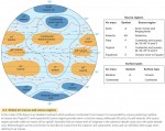
How Do Earth’s Four Spheres Interact?
ENERGY AND MATTER MOVE between the land, water, atmosphere, and biosphere — between the four spheres. There are various expressions of these interactions, many of which we can observe in our daily lives. In addition to natural interactions, human activities, such as the clearing of rain forests, can affect interactions between the spheres. Changes in […]
What Are Some Important Earth Cycles?
MATTER AND ENERGY MOVE within and between each of the four spheres. A fundamental principle of all natural sciences is that energy and matter can be neither created nor destroyed, but only transferred from one form to another — the First Law of Thermodynamics. A second principle is that energy and matter tend to become […]
How Do Natural Systems Operate?
EARTH HAS A NUMBER OF SYSTEMS in which matter and energy are moved or transformed. These involve processes of the solid Earth, water in all its forms, the structure and motion of the atmosphere, and how these three domains (Earth, water, and air) influence life. Such systems are dynamic, responding to any changes in conditions, […]
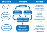
How Do We Investigate Geographic Questions?
PHYSICAL GEOGRAPHERS STUDY DIVERSE PROBLEMS, ranging from weather systems and climate change to ocean currents and landscape evolution. The types of data required to investigate each of these problems are equally diverse, but most geographers try to approach the problem in a similar, objective way, guided by spatial information, and relying on various geographic tools. […]
What Is Physical Geography?
PHYSICAL GEOGRAPHY IS THE STUDY of spatial distributions of phenomena across the landscape, processes that created and changed those distributions, and implications for those distributions on people. Geography is both a natural and social science. Geographers think broadly, emphasizing interconnections and complex issues, solving complicated problems such as resource management, environmental impact assessment, disease diffusion, […]
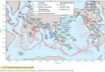
The Nature of Physical Geography
THE EARTH HAS A WEALTH of intriguing features, from dramatic mountains to intricate coastlines and deep ocean trenches, from lush, beautiful valleys to huge areas of sparsely vegetated sand dunes. Above the surface is an active, ever-changing atmosphere with clouds, storms, and variable winds. Occupying all these environments is life. In this chapter and book, […]
The Physical and Human Geographies of Japan
With its four major islands—Hokkaido, Honshu, Kyushu, and Shikoku—as well as thousands of smaller ones, Japan has a total land area of approximately 145,825 square miles. The distance from the northernmost tip of Hokkaido to extreme southern Kyushu is approximately the same as the distance from Bangor, Maine, to Mobile, Alabama, in the United States […]
Physical Landscapes
Three major landform regions divide Chile: the Andes Mountains, the coast and islands, and the Central Valley. The regions run north to south and parallel to each other. The Andes region is an awesome mountain barrier. Its majestic peaks of spectacular height and bone-chilling temperatures define the country's eastern border. The nation's coast includes imposing […]
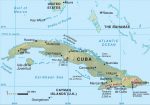
Physical Landscapes
Although we often speak of Cuba as one island, Cuba is actually an archipelago, or group of islands, whose total combined area is 42,803 square miles (110,860 square kilometers). Cuba is the largest island in this archipelago, making up 95 percent of the total land area of the island group. The second largest island, Isla […]
Physical Landscapes
The natural environment forms the foundation upon which all human societies depend for their survival. This is not to say that nature determines the way people live within a particular natural setting. To the contrary, a people's culture, or their way of life, is determined by human ingenuity—what they have learned and are able to […]
Poland: Physical Landscapes
A country's physical environment can offer opportunities and challenges to its people. Poland's natural conditions are no exception. Nature provides the canvas upon which people paint their own unique cultural landscapes—the human imprint on Earth's surface. People are guided by their particular needs, as well as by the financial and technological resources they command. The […]
Ireland’s Physical Environment
Fado, fado, Ireland's geologic roots began with the formation of Western Europe. The island of Ireland today is a direct result of the earth-building forces that created Eurasia over two billion years ago. Over time, layers of sediment accumulated on the floor of ancient geologic seas, creating limestone. A mixture of this limestone and lava […]
Germany: Physical Landscapes
Germany has an area of 137,847 square miles (357,021 square kilometers). It stretches about 520 miles (840 kilometers) north to south, reaching from 47 to 55 degrees north latitude, and 385 miles (620 kilometers) east to west, between 6 and 15 degrees east longitude. The terrain can be divided into three regions that increase in […]
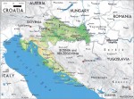
Croatia: Physical Environment
In terms of its natural environment, Croatia is a tourist's dream come true. The country shares many similarities with California. Both are blessed with a very mild and pleasant Mediterranean climate. They both have long coastlines that rank among the world's most scenic. Each location has varied terrain, contributing to diverse landscapes and ecosystems. Unlike […]
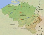
Belgium: Physical Landscapes
Belgium has a land area of 11,787 square miles (30,528 square kilometers), which, as already has been noted, is roughly equivalent in size to Maryland. Most of the country's territory lies on a huge lowland plain that stretches from the Pyrenees eastward to the Urals. In this chapter, we will look at Belgium's land areas, […]
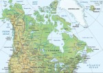
Canada: Physical Landscapes
Canada is a vast country with a great variety of impressive scenery. The natural environment, or physical landscape, provides the stage upon which human cultures play out their ways of living. In this regard, Canada is blessed in countless ways—its land regions, weather and climate, ecosystems, water features, and other natural resources offer much diversity […]
Physical Geography
Nature has blessed and in some ways cursed the United States. No country on Earth can match America’s diverse physical conditions and the resulting natural landscapes. The United States holds the distinction of being the only country that has within its territory all of the world’s climates and ecosystems (a combination of climate, natural vegetation and animal life, soils, […]
The Ice Age
Glaciation occurs when temperatures fall in regions of ample snowfall, allowing ice to accumulate and build. Although glaciation is a general term for the glacier growth and landform modification produced by glaciers, here we use it to refer to the period when continental ice sheets grow and spread outward over vast areas. When the climate warms or snowfall decreases, ice sheets become thinner and cover less […]
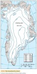
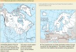
Ice Sheets and Sea Ice
The ice sheets of Antarctica and Greenland are huge plates of ice, thousands of meters thick in the central areas, resting on large land masses. The Greenland Ice Sheet has an area of 1.7 million km2 (about 670,000 mi2) and occupies about seven-eighths of the entire island of Greenland (Figure 17.11). The only land exposed is a narrow, mountainous coastal strip. […]
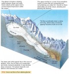
Alpine Glaciers
Figure 17.5 shows a cross section of an alpine glacier, illustrating a number of features. The glacier forms in a cirque—a high rock basin in which snow accumulates for year after year until it forms a glacier. Although the uppermost layer of a glacier is brittle, the ice beneath behaves as a plastic substance that flows slowly (Figure 17.6). An alpine […]
Glaciers
Not long ago, during the Ice Age, much of northern North America and Eurasia was covered by massive sheets of glacial ice. As a result, glacial ice has shaped large landforms in midlatitude and subarctic zones. Today, we find glacial ice in the Greenland and Antarctic Ice Sheets and in many smaller masses in high mountains. Glacial ice sheets have […]
Ice Sheets, Sea Ice, and Global Warming
What effects will global warming have on the Earth's ice sheets and sea ice? In general, global climate models predict two types of changes in the Earth's ice sheets. First, warming on land and ocean will cause the melting and thinning of the edges and ice shelves of the Greenland and Antarctic ice caps. This will increase sea level. Second, warming […]
Sand Dunes and Loess
A sand dune is any hill of loose sand shaped by the wind. Sand dunes form where there is a source of sand—for example, a sandstone formation that weathers easily to release individual grains, or perhaps a beach supplied with abundant sand from a nearby river mouth. Active dunes constantly change shape under wind currents, but they must be free of […]
Wind Action
Wind plays a direct role in shaping coastal landforms, carrying sand and other sediments, and depositing them at new locations. We use the term eolian, which comes from “Aeolus,” the name of the Greek god of the winds, to describe wind-generated landforms and processes. Dunes are thus eolian landforms. Figure 16.27 is a global map showing regions where eolian processes and landforms are found. […]
Types of Coastlines
Although every coastline is a unique creation of ocean waves acting on distinctive land masses, we can identify seven important types of coasts, shown in Figure 16.18. Coastlines of submergence are formed when the rising sea level partially drowns a coast or when part of the crust sinks. This group includes ria coasts and fiord coasts. Another group of coastlines […]
The Work of Waves and Tides
Wind, like running water, glacial action, and mass wasting, is an agent that shapes distinctive landforms. Wind can move material directly, picking up fine particles and carrying them from one place to another. Or it can act indirectly, by the action of wind-driven waves. What makes wind and breaking waves different from the other agents is that they can move material […]
Global Change and Coastal Environments
Global climate change over the remainder of the twenty-first century will have major impacts on coastal environments. The changes include increases in seasurface temperature and sea level, decreases in sea-ice cover, and changes in salinity, wave climate, and ocean circulation. What changes have already occurred? According to recent reports of the Intergovernmental Panel on Climate Change, sea level has risen about 15 […]
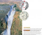
Fluvial Landscapes
GREAT WATERFALLS Large waterfalls are comparatively rare the world over, since the stream gradation process drains lakes and removes falls and rapids. But when tectonic activity fractures and dislocates crustal blocks, erosion may be hard pressed to keep up. As a result, we see great waterfalls on several large rivers in the African Rift Valley region. One of these is Victoria […]
The Work of Streams and Stream Gradation
Streams carry out three closely related activities—stream erosion, stream transportation, and stream deposition. Mineral materials, from bedrock or regolith, are removed from the floor and sides of the stream channel by erosion. The particles are suspended in the stream by turbulent water motion or are dissolved and held in solution. The transported particles are finally deposited on the streambed and floodplain, or […]
Slope Erosion
Most of the world's land surface has been sculpted by running water. Waves, glacial ice, and wind also carve out landforms, but for physical geographers, running water is the most important. That's because landforms made by glacial ice, wind, and waves are restricted to certain areas on the globe. We'll look at some of these other landformcreating agents in later chapters, […]
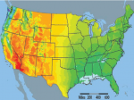
Surface Water as a Natural Resource
Fresh surface water is a basic natural resource essential to human agricultural and industrial activities. Runoff held in reservoirs behind dams provides water supplies for great urban centers, such as New York City and Los Angeles, as well as irrigation water for agriculture. We can also generate hydroelectric power from surface water where the gradient of a river is steep. […]
Lakes
A lake is a body of standing water with an upper surface that is exposed to the atmosphere and does not have an appreciable gradient. Ponds, marshes, and swamps with standing water can all be included under the definition of a lake. Lakes receive water from streams, overland flow, and ground water, and so they form part of drainage systems. Many […]
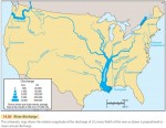
Streamflow and Floods
Stream discharge increases after heavy rainfall or snowmelt. But there is a delay in this increase because it takes time for the water to move into stream channels. The length of this delay depends, among other factors, on the size of the drainage basin feeding the stream. Larger drainage basins show a longer delay. It's easiest to look at the […]
Surface Water
OVERLAND FLOW AND STREAMFLOW Runoff that flows down the land slopes in broadly distributed sheets is called overland flow. This is different from streamflow, in which the water runs along a narrow channel between banks. Overland flow can take several forms. Where the soil or rock surface is smooth, the flow may be a continuous thin film, called sheet flow. […]
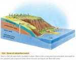
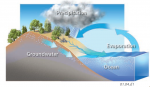
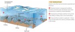
Ground Water
Water from precipitation can flow through the soil-water belt under the force of gravity. We call this flow percolation. Eventually, the percolating water reaches ground water. Ground water is the part of the subsurface water that fully saturates the pore spaces in bedrock, regolith, or soil (Figure 14.6). The top of the saturated zone is marked by the water table. Above […]
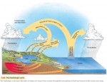
The Hydrologic Cycle Revisited
Water is essential to life. Nearly all organisms require constant access to water or at least a water-rich environment for survival. Humans are no exception. We need a constant supply of fresh water from precipitation over the lands. Some of this water is stored in soils, regolith, and pores in bedrock. And a small amount of water flows as fresh water […]
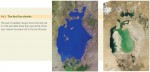
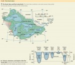
The Aral Sea
East of the Caspian Sea, astride the former Soviet republics of Kazakhstan and Uzbekistan, lies an immense saline lake—the Aral Sea. Fed by meltwaters of high glaciers and snowfields in the lofty Hindu Kush, Pamir, and Tien Shan Ranges, the lake endured through thousands of years as an oasis for terrestrial and aquatic wildlife deep in the heart of the central […]
Processes and Landforms of Arctic and Alpine Tundra
The treeless arctic and alpine tundra environment is severely cold in winter. In the tundra, soil water is solidly frozen for many months. During the short summer season, however, the surface thaws, leaving the soil saturated and vulnerable to mass wasting and water erosion. With the return of cold temperatures, the freezing of soil water exerts a strong mechanical influence on the […]
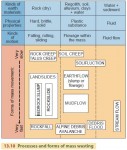
Mass Wasting
So far, we've looked at a selection of processes that alter rock chemically or break them into fragments. But what happens to these pieces once they've been loosened from the parent rock? The rock fragments are subjected to gravity, running water, waves, wind, and the flow of glacial ice. In this chapter we'll concentrate on the effect of gravity, and we'll […]
Weathering
In the last few chapters, we've looked at the Earth's crust—its mineral composition, its lithospheric plates, and the landforms created by volcanic and tectonic activity. Now let's examine the shallow surface layer in which life exists. We'll look first at how rocks are softened and how they break up. Later, we'll see how the resulting rock materials move downhill under the […]
The Madison Slide
For some 200 vacationers camping in a deep canyon on the Madison River just downstream from Hebgen Lake, not far west of Yellowstone National Park, the night of August 17, 1959, began quietly, with almost everyone safely bedded down in their tents or camping trailers. Up to a certain point, it was everything a great vacation should be—that point in time […]
Landforms and Rock Structure
Over the world's vast land area, you'll see many types of rock and rock structures. In many cases, rock structure controls the locations of uplands and lowlands, as well as the routes of streams and rivers. Rock structure affects landforms because different types of rocks are worn down by erosion at different rates. Some rock types are easily eroded, while others are […]
Earthquakes
You've probably seen the destruction wrought by e arthquakes on the television news. Californians know about this first-hand, and several other areas in North America have also experienced strong earthquakes. Earthquakes range from faint tremors to wild motions that shake buildings apart. Most earthquakes are produced by sudden slip movements along faults. These happen because rock on both sides of the fault is slowly bent […]
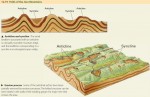
Tectonic Landforms
There are two basic forms of tectonic activity: compression and extension. Compression occurs when lithospheric plates are squeezed together along converging lithospheric plate boundaries, while extension happens along continental and oceanic rifting, where plates are being pulled apart. FOLD BELTS Let's start by looking at folding produced by compression. When two continental lithospheric plates collide, the plates are squeezed together at the boundary. The crust crumples, creating […]
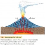
Volcanic Landforms
Landforms are the surface features of the land—for example, mountain peaks, cliffs, canyons, plains, beaches, and sand dunes. Landforms are created by many different processes that we will describe in the remainder of this book. Geomorphology is the scientific study of the processes that shape landforms. In this chapter, we will look at landforms produced directly by volcanic and tectonic processes. […]
The Indian Ocean Tsunami of 2004
One of the most dangerous side effects of tectonic activity is the tsunami—a great ocean wave produced by an undersea earthquake or volcanic explosion. When a tsunami arrives at a coastline, it causes a temporary and rapid rise of sea level. Ocean waters rush landward and surge far inland, destroying coastal structures and killing inhabitants. After some minutes, the waters retreat, continuing […]
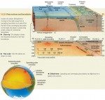
Plate Tectonics
On the globes and maps we've seen since childhood, the outline of each continent is so unique that we would never mistake one continent for another. But why are no two continents even closely alike? The answer lies in the long formation history of the Earth's surface features, which is driven by the movement of lithospheric plates. The science of lithospheric […]
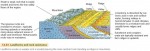
Major Relief Features of the Earth’s Surface
THE LITHOSPHERE AND ASTHENOSPHERE The major relief features of the Earth—its continents and ocean basins—were created by the movements of plates on the surface of the Earth. Geologists use the term lithosphere to describe an outer Earth shell of rigid, brittle rock, including the crust and also the cooler, upper part of the mantle (Figure 11.15). The lithosphere ranges in thickness […]
Minerals and Rocks of the Earth’s Crust
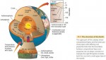
What lies deep within the Earth? Our planet has a central core with several layers, or shells, surrounding it. The densest matter is at the center, and each layer above it is increasingly less dense. THE EARTH'S INTERIOR Our planet is almost spherical, with a radius of approximately 6400 km (about 4000 mi). Its central core is about 3500 km […]
The Global Scope of Soils
How soils are distributed around the world helps to determine the quality of environments of the globe. That's because soil fertility, along with the availability of fresh water, is a basic measure of the ability of an environmental region to produce food for human consumption. We classify soils according to a system developed by scientists of the U.S. Natural Resources Conservation Service, […]
Soil Development
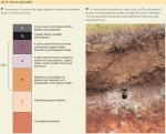
How do soils develop their distinctive characteristics? Let's turn to the processes that form soils and soil layers. SOIL HORIZONS Most soils have distinctive horizontal layers that differ in physical composition, chemical composition, organic content, or structure (Figure 10.12). We call these layers soil horizons. They develop through interactions between climate, living organisms, and the land surface, over time. Horizons usually […]
The Nature of the Soil
This chapter is devoted to soil systems. Soil is the uppermost layer of the land surface that plants use and depend on for nutrients, water, and physical support. Soils can vary greatly from continent to continent, from region to region, and even from field to field. This is because they are influenced by factors and processes that can vary widely from […]
Global Change and Agriculture
For the remainder of the twenty-first century, and probably well beyond, our global climate will change. The Earth will become warmer, especially in mid- and high latitudes. Most areas will have more precipitation, although higher temperatures will often bring more summer drought stress. Extreme events—heavy rainfalls and high winds—will be more frequent. How will global climate change impact agriculture? (Figure 10.1) In […]
Mapping Global Land Cover by Satellite
Imagine yourself as an astronaut living on an orbiting space station, watching the Earth turn underneath you. One of the first things that would strike you about the land surface is its color and how it changes from place to place and time to time. Deserts are in shades of brown, dotted with white salty playas and the black spots and streaks of recent volcanic […]
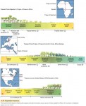
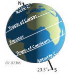
Climate and Altitude Gradients
CLIMATE GRADIENTS AND BIOME TYPES As we have seen, biomes and formation classes change along with climate. Figure 9.34 shows three continental transects that illustrate this principle. The upper transect stretches from the Equator to the Tropic of Cancer in Africa. Across this region, climate ranges through all four low-latitude climates: wet equatorial, monsoon and trade-wind coastal, wet-dry tropical , […]
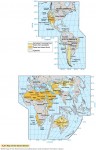
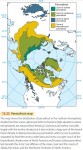
Desert and Tundra Biomes
DESERT BIOME The desert biome includes several formation classes that are transitional from grassland and savanna biomes into vegetation of the arid desert. Our map of the desert biome (Figure 9.28) recognizes two basic formation classes: semidesert and dry desert. Semidesert is a transitional formation class found in a wide latitude range—from the tropical zone to the midlatitude zone. It is […]
Savanna and Grassland Biomes
SAVANNA BIOME The savanna biome is usually associated with the tropical wet-dry climate 3 of Africa and South America. Its vegetation ranges from woodland to grassland. In savanna woodland, the trees are spaced rather widely apart because there is not enough soil moisture during the dry season to support a full tree cover. The open spacing lets a dense lower layer […]
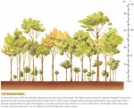
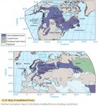
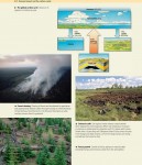
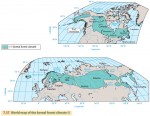
Forest Biome
Within the forest biome, we can recognize six major formations: low-latitude rainforest, monsoon forest, subtropical evergreen forest, midlatitude deciduous forest, needleleaf forest, and sclerophyll forest. Ecologists sometimes recognize three principal types of forest as separate biomes, based on their widespread nature and occurrence in different latitude belts: low-latitude rainforest, midlatitude deciduous and evergreen forest, and boreal forest. LOW-LATITUDE RAINFOREST Low-latitude rainforest, found in […]
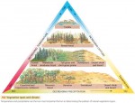
Terrestrial Ecosystems — The Biomes
For humans, ecosystems are great natural factories producing food, fiber, fuel, and structural material. These useful products are manufactured by organisms using energy from the Sun, and we harvest that energy by using these ecosystem products. The products and productivity of ecosystems depend on their climate. Where temperature and rainfall cycles permit, ecosystems provide a rich bounty. Where temperature or rainfall cycles restrict […]
Natural Vegetation
Over the last few thousand years, human societies have come to dominate much of the land area of our planet. We've changed the natural vegetation—sometimes drastically—of many regions. What exactly do we mean by natural vegetation? Natural vegetation is a plant cover that develops with little or no human interference. It is subject to natural forces, storms, or fires that […]
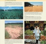
Exploitation of the Low-Latitude Rainforest Ecosystem
Many of the world's equatorial and tropical regions are home to the rainforest ecosystem. This ecosystem is perhaps the most diverse on Earth, possessing more species of plants and animals than any other. Very large tracts of rainforest still exist in South America, south Asia, and some parts of Africa. Ecologists regard this ecosystem as a genetic reservoir of many species […]
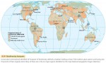
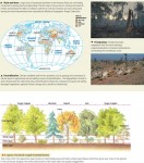
Biodiversity
Today, global biodiversity—the variety of biological life on Earth—is rapidly decreasing. Two out of every five species on the planet that have been assessed by scientists face extinction, according to the International Union for Conservation of Nature and Natural Resources (Figure 8.37). Our species, Homo sapiens, has ushered in a wave of extinctions unlike any that has been seen for millions of years. In the last […]
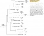
Historical Biogeography
Thus far, we've looked at ecological processes that produce biogeographic patterns at local and regional spatial scales. We now turn to patterns at continental and global scales that develop over longer time periods. Historical biogeography focuses on how these spatial distribution patterns arise over space and time through four key processes: evolution, speciation, extinction, and dispersal. EVOLUTION An astonishing number of […]
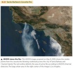
Remote Sensing of Fires
Wildfires occur frequently on the Earth's land surface, and biomass burning has important effects on both local and global ecosystems. Biomass burns inefficiently, releasing not only carbon dioxide and water, but also a number of other greenhouse gases that absorb outgoing longwave radiation and enhance the greenhouse effect. Aerosols are another by-product of inefficient combustion that can effect atmospheric processes. Burning mobilizes such nutrients as nitrogen, phosphorus, and sulfur […]
Ecological Succession
Plant and animal communities change through time. Walk through the country and you'll see patches of vegetation in many stages of development—from open, cultivated fields through grassy shrublands to forests. Clear lakes gradually fill with sediment and become bogs. We call these changes—in which biotic communities succeed one another on the way to a stable end point—ecological succession. In general, succession forms the most complex community of organisms possible, […]
Ecological Biogeography
We've seen how energy and matter move through ecosystems. But if we want to fully understand ecosystems, we'll also need to look at ecological biogeography, which examines the distribution patterns of plants and animals from the viewpoint of their physiological needs. That is, we must examine how the individual organisms of an ecosystem interact with their environment. From fungi digesting organic matter […]
Energy and Matter Flow in Ecosystems
This chapter is the first of two chapters that look at biogeography. Biogeography focuses on the distribution of plants and animals—the biota—over the Earth. It identifies and describes the processes that influence plant and animal distribution patterns. Ecological biogeography looks at how the distribution patterns of organisms are affected by the environment. Historical biogeography focuses on how spatial distribution patterns of organisms arise […]
Human Impact on the Carbon Cycle
Carbon is an element that is abundant at the Earth's surface and is also essential for life. Carbon cycles continuously among the land surface, atmosphere, and ocean in many complex pathways. However, these flows are now strongly influenced by human activity. The most important human impact on the carbon cycle is the burning of fossil fuels, which releases carbon dioxide (CO2) into […]
High-Latitude Climates (Group III)
By and large, the high-latitude climates are climates of the northern hemisphere, occupying the northern subarctic and arctic latitude zones. But they also extend southward into the midlatitude zone as far south as about the 47th parallel in eastern North America and eastern Asia. One of these, the ice sheet climate, is present in both hemispheres in the polar zones. The […]
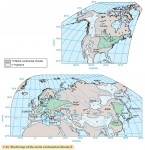
Midlatitude Climates (Group II)
The midlatitude climates almost fully occupy the land areas of the midlatitude zone and a large proportion of the subtropical latitude zone. They also extend into the subarctic latitude zone, along the western fringe of Europe, reaching to the 60th parallel. Unlike the lowlatitude climates, which are about equally distributed between northern and southern hemispheres, nearly all of the midlatitude climate area […]

Low-Latitude Climates (Group I)
The low-latitude climates lie for the most part between the Tropics of Cancer and Capricorn, occupying all of the equatorial zone (10° N to 10° S), most of the tropical zone (10–15° N and S), and part of the subtropical zone. The low-latitude climate regions include the equatorial trough of the intertropical convergence zone (ITCZ), the belt of tropical easterlies (northeast and […]
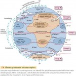
Climate Classification
Mean monthly values of air temperature and precipitation can describe the climate of a weather station and its nearby region quite accurately. To study climates from a global viewpoint, climatologists classify these values into distinct climate types. This classification requires developing a set of rules to use in examining monthly temperature and precipitation values. By applying the rules, a climatologist can use […]
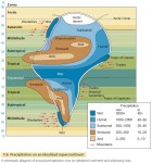
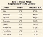
Temperature and Precipitation Regimes
Many parts of the world show distinctive patterns of monthly temperature and precipitation, usually related to latitude and location. These patterns are referred to as regimes of temperature and precipitation. TEMPERATURE REGIMES Figure 7.5 shows annual cycles of air temperature for different temperature regimes. The equatorial regime (Douala, Cameroon, 4° N) is uniformly very warm, with temperatures close to 27°C (81°F) […]
Factors Controlling Climate
Climate is the average weather of a region. The primary driving force for weather is the flow of solar energy received by the Earth and atmosphere. Because that energy flow varies on daily cycles with the planet's rotation and on annual cycles with its revolution in orbit, temperature and precipitation also vary on daily and annual cycles. However, climate includes […]
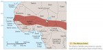
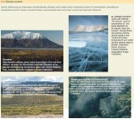
Drought in the African Sahel
One of the Earth's more distinctive climates is the wetdry tropical climate . Here, the weather is largely dry for much of the year, but there is a rainy season of a few months duration in which most of the annual rainfall occurs. Precipitation during the wet season is quite variable, ranging from little or none to torrential rainfalls that produce […]
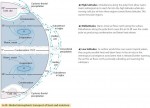
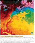
Poleward Transport of Heat and Moisture
As we saw in Chapter 5, the general circulation of the atmosphere and oceans is driven by the difference in solar heating between low and high latitudes. This general circulation, combined with jet stream disturbances in the midlatitudes, serves to redistribute heat and moisture from the Equator to the poles in the process of poleward heat transport. Figure 6.30 shows the various mechanisms by which this […]
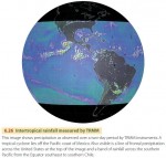
The Tropical Rainfall Monitoring Mission
In November of 1997, NASA and the Japanese Space Agency launched a joint satellite mission with the goal of monitoring rainfall in the tropical and equatorial regions of the world—the Tropical Rainfall Monitoring Mission (TRMM). Its operational objective is to provide more information about where and when intertropical convective precipitation occurs, particularly over oceans, which are not monitored by weather stations and rain gauges. The mission is also designed […]
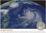
Tropical and Equatorial Weather Systems
So far, we have discussed weather systems of the midlatitudes and poleward. Weather systems of the tropical and equatorial zones show some basic differences from those of the midlatitudes. Upper-air winds are often weak, so air-mass movement is slow and gradual. Air masses are warm and moist, and different air masses tend to have similar characteristics, so fronts are not as clearly defined. Without the […]
Midlatitude Anticyclones and Cyclones
Air masses are set in motion by wind systems—typically, masses of air moving in a spiral. Air can spiral inward and converge in a cyclone, or spiral outward and diverge in an anticyclone. Most types of cyclones and anticyclones are large features spanning hundreds to thousands of kilometers that move slowly across the Earth's surface, bringing changes in the weather as […]
Air Masses
We know that the Earth's atmosphere is in constant motion, driven by the planet's rotation and its uneven heating by the Sun. The horizontal motion of the wind moves air from one place to another, allowing air to acquire characteristics of temperature and humidity in one region and then carry those characteristics into another region. In addition, as winds at the […]
Cloud Cover, Precipitation, and Global Warming
Clouds are so common we don't think much about them. But they can have a large impact on climate. How would global climate be influenced by an increase in clouds and precipitation? Global temperatures have been rising over the last 20 years. Satellite data show a rise in temperature of the global ocean surface of about 1°C (1.8°F) over the past […]
Ocean Circulation
Just as there is a circulation pattern to the atmosphere, there is also a circulation pattern to the oceans that it is driven by differences in density and pressure acting along with the Coriolis force. Pressure differences are created in the water when the ocean is heated unequally, because warm water is less dense than cold water. These pressure differences induce […]
Winds Aloft
We've looked at airflows at or near the Earth's surface, including both local and global wind patterns. But how does air move at the higher levels of the troposphere? Like air near the surface, winds at upper levels of the atmosphere move in response to pressure gradients and are influenced by the Coriolis effect. How do pressure gradients arise at […]
Global Wind and Pressure Patterns
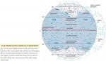
For simplicity, let's begin by looking at surface winds and pressure patterns on an ideal Earth that does not have oceans and continents, or seasons (Figure 5.16). Hadley cells are key to an understanding of the wind patterns on our ideal Earth. These form because the Equator is heated more strongly by the Sun than other places, creating thermal circulations. Air […]
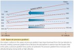
Cyclones and Anticyclones
THE CORIOLIS EFFECT We have seen that the pressure gradient force moves air from high pressure to low pressure. For sea and land breezes, which are local in nature, this pushes wind in about the same direction as the pressure gradient. But on global scales, the direction of air motion is more complicated. The difference is caused by the Earth's rotation, through the Coriolis effect (Figure 5.13). The Coriolis effect […]
Local Wind Patterns
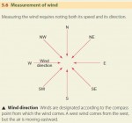
Wind is defined as air moving horizontally over the Earth's surface. Air motions can also be vertical, but these are known by other terms, such as updrafts or downdrafts. Wind direction is identified by the direction from which the wind comes—a west wind blows from west to east, for example. Like all motion, the movement of wind is defined by its […]