City-Region
Origin of the City-Region
Since the 1990s, there has been a remarkable resurgence of the concept of the city-region in both academic and policy communities. In broad terms, the concept articulates the relationships between the city and its environs. For almost 30 years the focus on the city-region had been overshadowed by a shift of emphasis toward urban and particularly inner urban issues. Hence, its revival is not only a reincarnation of an analytical construct to understand the complex spatial relations, but also a manifestation of a political move toward new regionalism. This has been coupled with the struggle over the rescaling of the state intervention to intermediate levels such as the city-region.
While the city-region's rising popularity is recent, its origin is not. The idea that the city cannot be understood fully by reference only to its administrative boundaries has a long history.While the term itself is thought to have been coined by Robert Dickinson in 1947, the concept can be traced back to an even earlier time in both theoretical and applied studies as well as planning practices. An example of the latter is the 1909 Plan of Chicago which promoted a regional vision of the city which extended well beyond its administrative boundaries. Similarly, in 1915 Patrick Geddes, the Scottish planner, used the notion of conurbation to advocate the need for planning to take into account the resources of the region in which the historic but rapidly spreading cities are situated. In 1933, R. D. McKenzie, an American sociologist, pointed out that the metropolitan region was primarily a functional entity.
However, despite its long history the concept of the city-region does not enjoy a common definition; neither in its use as an analytical term nor in its upsurge as a political one. Analytically, it represents different spatial entities depending on how it has been arrived at methodologically. Politically, it means different things depending on the type of policy agenda it serves. In practice, the concept is frequently used simply to refer to the areal extent of a metropolitan area. While there are clear linkages between the analytical and political usages of the concept, the main focus of this article is on the city-region as an analytical construct. As such, a key contribution of the concept to spatial thinking is its departure from a preoccupation with the physical structure of the city and the urban form per se toward a focus on the relational dynamics of the social networks and urban functions which often transcend the bounded perceptions of space. Hence, the contemporary relevance and significance of the city-region concept lies in its potential: first, to evoke a relational understanding of space and place in policy and practice; second, to encourage researchers to seek new methodologies for mapping the less tangible interconnections which define the virtual contours of what Manuel Castells calls the space of flows; and third, to contribute to the debate about metropolitan governance.
Conceptions of the City-Region
Since the 1950s, there have been a myriad of studies attempting to: define the components of the city-region; identify, measure, and map its boundaries; and, understand the interactions between its constituent parts. Despite their variations, they share two common features: first, they portray an urban-centric conception of the city-region which puts the emphasis on the city, sometimes at the expense of neglecting the region. Second, they represent an economically driven approach to city-region definition in which the dominant economic flows determine the extent of the city-region. Exceptions to these do exist but are rare and more recent.
The supremacy of the urban-centric view lies partly in the historical evolution of the spatial structure of the city-region. This until the mid twentieth century was largely influenced by a continuing concentration of population and economic activities in the core city in most of the developed world. Although this trend began to reverse in the latter part of the twentieth century – when, mainly in the West, population and employment began to decentralize – it did not substantially change the urban-centric perspective. Indeed, such a view has been further boosted in the twenty first century by the apparent re emergence of the cities as the magnets for attracting population and economic activities. It is argued that regions with successful core cities at their heart can develop a vibrant and continually evolving hierarchy of settlements of different sizes that carry out a wide range of functions. Embedded within this view of the city-region is an implicit recourse to Christaller's 'central place' theory. The theory implies a nesting hierarchy of cities which serves populations drawn from within regular hexagonal catchment zones at successively larger scales.
The continuing dominance of the economically driven approach may be explained by the prevailing policy frameworks based on competitive city-regionalism. Indeed, what underpins the re emergence of the city-region since the late 1990s is a growing conviction that participation in the service intensive global economy has led to greater spatial concentration of activities. As a result, cities are re emerging as production sites and as the powerhouses of modern, advanced economies, where the creation of unique knowledge is of greater significance than exploitation of natural resources or mass production. It is argued that city location is as important for this new knowledge based economy as factory floor space was for the industrial economy. This has made city-regions an insistent element of the geographic landscape. Will Hutton has called these post-industrial cities the 'ideopolis', arguing that they represent a twenty first century metropolitan version of what we first saw in Italian renaissance city states. Their buoyant demand, intellectual capital, and business self confidence help to create and sustain new ideas. Among the common features which underpin the successful performance of post-industrial cities are a diverse economic base, internal and external connectivity, quality of life, skills and human capital, innovation in firms and institutions, leadership, and strategic decision taking capacity.
Built on these arguments, it is concluded that the competitiveness of major cities is the key determinant of regional performance in advanced knowledge based economies.
The City-Region Interactions
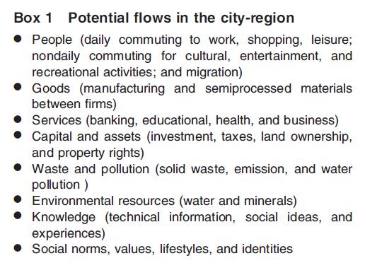
The economic approach to city-region is a limited one because it fails to recognize a full spectrum of city-regional relationships, which constitute a complex web of visible and invisible multidirectional flows of not only economic but also social, cultural, and environmental activities (see Box 1).
Through these interactions, cities and regions may share a mutually reinforcing relationship. Furthermore, each of these interactions creates its own spatial imaginaries and functional boundaries which do not always overlap. The outcome is a complex web of interactions and a multiplicity of boundaries. Hence, city-region boundaries do not constitute precise lines; instead they are blurred, if not indeterminate. However, despite a long standing recognition of the complexity and emergence of the city-region spatial structures, attempts to define the city-region have remained entirely focused on its economic functions. Hence, it remains the case that the most widely recognized and deeply embedded interpretation of the city-region is its conceptualization as a functional economic space.
City-Region as a Functional Economic Space
Conceptualizing the city-region as a functional economic space – pioneered by Brain Berry in 1968 – has remained an enduring and powerful spatial imagination. Within this perspective, the city-region is depicted as a largely self contained and integrated economic entity, commonly known as the functional urban region (FUR). The concept of FUR was first developed in America as a way of moving away from an earlier population based concept of metropolitan district which referred to urban agglomerations with more than 200 000 populations. The shift took place when Gras used economic rather than spatial criteria to identify 14 metropolitan areas in North America. Later, the notion of metropolitan area was formally adopted by the United States Bureau of the Census in 1950. These were called the Standard Metropolitan Statistical Area (SMSA) and referred to areal unit of over 50 000 population. The defining characteristic of the metropolis was considered to be the commuting pattern of the workforce which was assumed to be radial from the periphery to the center(s) where the jobs were located. In Britain, the notion of 'conurbation', which was coined by Patrick Geddes in 1915 and further developed by Fawcett in 1932, was spatially, rather than functionally, defined. Fawcett defined seven conurbations in Britain which more or less corresponded to those that were later delineated by the statisticians in the General Register Office (GRO) using the 1951 census. So, at the time when the British statistical authorities were using the concept of conurbation defined largely on the basis of physical extent of the city, on the other side of Atlantic, SMSA put functional integration at the center of the definition of metropolitan areas.
Meanwhile, in other parts of Europe, researchers were drawing on criteria similar to the ones used to define SMSA in order to delineate city-regions. A notable example is Hans Carol's definition of Zurich city-region in 1956. Given Christaller's strong influence in the continent, Carol combined the two approaches (one based on commuting data to define the city-region and the other based on the range of services to define the hierarchy of service centers) to map the arrangement of central places in the city-region of Zurich. He then argued that a planned decentralization of activities should be guided by this framework. By the 1970s, these were also introduced in the UK by Peter Hall and his study of Standard Metropolitan Labor Areas (SMLA) for England and Wales. Both SMSA and SMLA consist of the historic city and its commuting hinterland instead of being limited to the continuously built up area centered upon a particular city. The functional approach to city-region definition has been further advanced by studies such as those undertaken by Mike Coombes and Paul Cheshire in Britain as well as through pan European research programs such as the European Spatial Planning Observation Network (ESPON).
Regarding its utility, the FUR is often seen as an organizing mechanism in the national space economies. However, evidence from the survey conducted by the Organization for Economic Cooperation and Development (OECD) in 2002 of its members has revealed that this is not the case in countries such as Japan, Mexico, Korea, Spain, and Turkey. Furthermore, the official recognition of the FUR as a framework for policy implementation varies considerably from one country to another. In some countries, such as Austria, Denmark, and Switzerland, FURs are used as a framework for the implementation of policies relating mainly to labor market and transport. In other countries such as Finland, France, Germany, Italy, and the UK, FURs serve as a basis for identifying areas which qualify for national or European aid. In Norway, the concept of FUR has played a significant role in the discussions about regionalism and new regional policy. In a fourth category, countries such as Portugal, Sweden, Czech Republic, and the United States do not use FURs as their official units for policy implementation. Nevertheless, adopting a FUR approach (as a proxy for the city-region) to policymaking has remained an attractive proposition particularly in the area of strategic planning where the need for coordination and integration of investments, policies, and programs is considered to be critical. Indeed, such arguments have underpinned the current debate over the co aligning of local government structures to that of the city-regions.
Mapping the City-Region
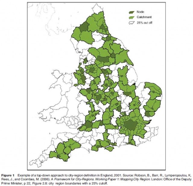
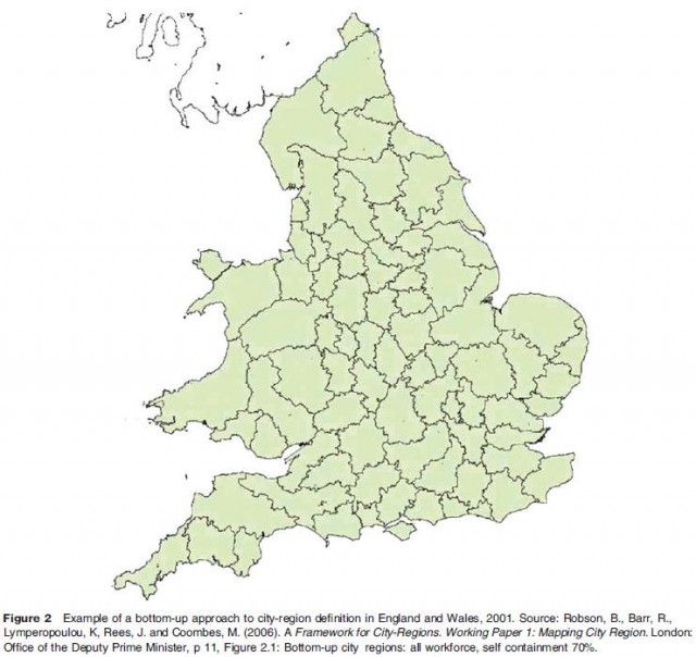
While there have been numerous attempts to define the city-region – as an FUR – the emphasis has remained on the city as the node of interactions, and on the economy (or indeed on work related commuting) as the determining function. This has largely shaped (and been shaped by) the methodologies that have been used to map the FURs. Despite their differences such methodologies fall into one of two broad categories: one is the top-down and deductive approach and the other is the bottom up and inductive approach.
The Top-Down Approach
In the top-down, deductive approach, analyses start from a predetermined set of cities as nodes or destinations for the economic flows and then move out to assign other areas to them. These cities (nodes) are selected on the basis of a specified set of functions, population size, economic performance (often measured by the gross domestic product), accessibility and connectivity, intensity of financial and business services, and so on. Depending on the weight given to the criteria for the selection of nodes, the number of cities and hence the frequencies of the city-regions reduce or increase. While a classic example of the top-down definition is the official definition of Metropolitan Statistical Areas in the US, the approach has also been used in countries such as Canada, France (urban areas), Germany, and Portugal, as well as in pan European studies such as ESPON.
The Bottom-Up Approach
In the bottom up, inductive approach, the city-regions emerge from the full set of commuting data through an algorithm which simultaneously optimizes the boundaries on the basis of a size of employment criterion and a minimum threshold of self containment of flows to workplaces. This approach has become feasible only recently as a result of advances in data manipulation and computation. It still remains an exceptional feature of a landscape which is dominated by the traditional top-down definition of the FUR. The most notable attempt to adopt the bottom up approach is the work undertaken by Coombes et al., in 1986. Different variations of this approach are also used in countries such as Finland, France (for defining employment areas), and Italy.
In technical terms, the first approach is nodal and nonexhaustive (not covering the whole of the national territory), while the second one is non nodal (or multinodal) and exhaustive, as illustrated in Figures 1 and 2. The first one is underpinned by an urban-centric conception of the city-region, while the second one marks a departure from it, shifting the emphasis from the city to the region. However, while the bottom up approach provides a more inclusive way of understanding the complex flows of commuting across a wider territory, it remains an economically driven approach and largely reliant on travel to work analyses.
One advantage of the non nodal approach is that it can reveal potential polycentric patterns in the wider region. As Davoudi has shown, promoting the development of such polycentric urban regions – where a number of neighboring and nonhierarchical cities interact with each other economically and complement each other in service provision – has become a central objective of the European spatial policy. However, given the dominance of the top-down approach and its upsurge in policy domain, the remaining sections of this article focus on providing an outline of its evolution and key features.
The Structure of the City-Region
The top-down approach attributes two distinct but interrelated components to the city-region: the inner core area (central urban tract) and the outer surrounding area which is associated with and sometimes dominated by the core. The two entities have been given various terminologies. The inner area has been called: the core, the center, the node, the city, and the urban tract. The outer area has attracted terms such as: the 'hinterland' by Gras in 1922, umland (the land around) by the German scholar Scho?ller in 1957, 'metropolitan community' by Bogue in1949, and the 'region' by McKenzie in1933 and Dickinson in 1947. For Mumford, the city's region is its field of association or catchment area. In 2005, Parr codified these two entities by calling them the 'C zone' and the 'S zone' to disassociate them from their historical baggage and to use categories that are exhaustive and mutually exclusive. For Dickinson, the outer area can be further divided into two categories: the city settlement area or the daily commuting area, and the city trade area or the catchment area for central services.
An early and striking example of a top-down, urban-centric view of the city-region is the one portrayed by Donald Bogue in 1949 who, drawing on biological analogies, delineated 67 metropolitan regions in America based on an arbitrary system of decreasing values, beginning with the metropolitan center as the dominant and followed by the hinterland city as subdominant, the rural nonfarm as influent, and the rural farm as subinfluent. Another example of identifying associational zones is the work undertaken by Boustedt in 1953. He defined the city-regions (stadtregion) of Germany as consisting of a core (one or more contiguous administrative units and associated gemeinden), an urbanized zone (versta?dterte zone), the fringe zone, and the wider area of umland within which the influence of the city predominates. Mapping the city-region (or more precisely the FUR) has invariably involved identifying such zonal arrangements. In the top-down approach, this involves first, defining the core and second, identifying the extent of its influence by measuring the economic flows to and from the core. These are elaborated in turn.
Defining the City in the City-Region
A top-down approach to map the city-region starts with defining the core city (or urban tract). Traditionally, this has referred to the compact and fairly continuous built up area. Such an area has also been a defining feature of conurbation as used by Fawcett in 1932. For him, a conurbation was an area occupied by a continuous series of dwellings which were not separated from each other by rural land. This approach and its follow up by British (GRO) and American statisticians (SMSA) were designed partly to distinguish the predominantly urban areas from the predominantly rural ones. In that sense, their understanding of conurbation was not the same as the one used by Patrick Geddes. His was more consistent with the wider concept of the city-region as a functional space and came closer to what Friedmann and Miller called the urban field.
Meanwhile, in France the notion of urban aggregates were defined – for the 1954 census – as those contiguous communes, which were linked together primarily in terms of family associations (cadre de l' existence familiale). This included the geographic framework in which, for example, schools and shops were located but excluded the workplaces. In Germany, while there were no official definitions of urban areas by census authorities at that time, there were several studies which attempted to define the city-region. A notable example is Hesse's work on typologies of gemeinden in southwest Germany in the 1940s.
Using the compactness of the urban uses as a criterion remains at the center of the statistical definition of the core city as well as the distinction between what is urban and what is rural. For example, in Finland (in common with other Nordic countries) a built up area, taajama, refers to a cluster of buildings containing at least 200 residents in which the distance between buildings does not exceed 200 m. However, given the diffusion of the urban–rural fringe, the definition of an urbanized core in terms of continuous urban land uses has become increasingly elusive and in many cases irrelevant. Definitions of the urban based on economic function have grown apart from definitions based upon physical development. For example, using the terms loosely, England is in physical terms predominantly rural but in socioeconomic terms overwhelmingly urban. Indeed, an important feature of the city-region, particularly when it is based on the bottom up approach, is its potential to reveal the multifaceted interrelationships between urban and rural areas within a particular spatial context.
Delineating the Extent of the City-Region
There are two ways of defining the city-region (or FUR) as a geographical entity: one is through statistical analysis of actual flows and the other is by an approximation of time–distance from the core. Both are briefly outlined below.
Measuring the flows
The focus of the statistically defined city-region is on measuring the precise areal extent of the city's associations.While such associations are dynamic and include a wide range of economic, social, and environmental links, the hegemony of economic discourse and economic data has meant that the only city-region interaction which has proved amenable to measurement and mapping is the flows of people or more precisely the flows of daily commuters to work. This is evident by the OECD's survey of its members which concludes that the most typical concept used in defining a functional region is that of labor markets.
Within this perspective, after the delineation of the core city, the extent of the FUR is determined by including each locality that has more than a given proportion of its active labor force working in the core city and hence commuting from such localities to the core on a daily basis. Clearly, the lower the proportion the larger will be the extent of the FUR and vice versa.
In technical terms, a low percentage point will cause overbounding, while a high threshold will lead to underbounding. In the case of the former, areas whose labor market linkages with the core are not above a certain threshold will be excluded from the resulting city-region, even if they may be tightly connected to it through, for example, environmental, cultural, or administrative ties. Conversely, when the threshold is low, the resulting FUR will engulf those cities and towns that fall within that threshold even if they assume historical and political independence. The issue is not a mere technical one, and can have far reaching implications for spatial planning, investment programs, and the sense of place and identity.
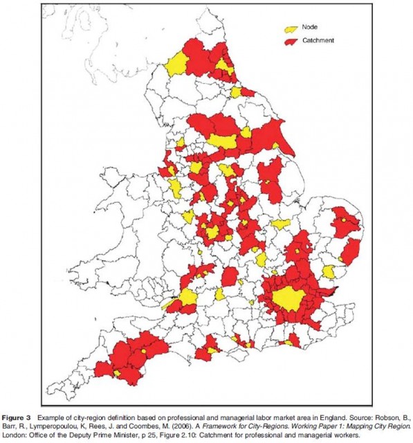
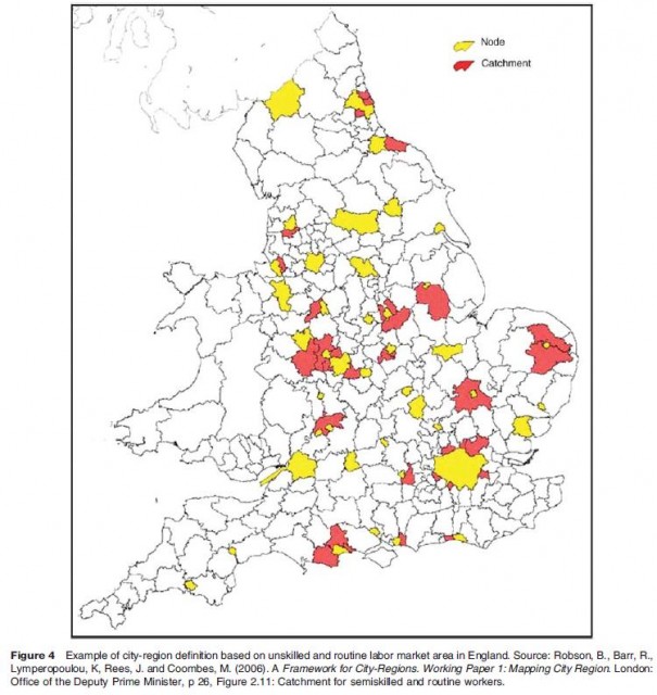
Indeed, a major criticism of conceptualizing the city-region as a FUR is its heavy reliance on not only one type of interaction (i.e., economic) but also on one economic criterion (i.e., travel to work) for measuring that interaction. Such reductionism has been compounded by a lack of attention to the differences between labor market areas. Often, the average commuting distance of the higher order occupational groups (such as professional and managerial) is much longer than the lower ones (such as unskilled manual), leading to more than one city-region boundary for one type of commuting, as shown in Figures 3 and 4.
Furthermore, labor market analyses have a limited utility in capturing the economic relationships of the FUR. For a more sophisticated approach other nonwork trip generation activities, such as journey to shops, services, and leisure facilities, need to be taken into account, despite the difficulties of measuring them. If that becomes feasible, the city-region boundaries will further diverge. Yet another complexity arises when the housing market areas are taken into account. It appears that for households making residential location decisions, the city-region boundary is defined by their mental maps of areas with which they are familiar. Such areas do not necessarily match that of the labor market area, hence creating yet another boundary for the city-region. In an ambitious attempt to move beyond the labor market areas and capture the economic relationships of the mega city-regions, a European project called Polynet has attempted to measure the interactions between the firms and particularly those which are key intermediaries in the knowledge economy such as, advanced business services, financial institutions, law, accountancy, and management consultancies. Given that much of such interactions take place in the cyberspace and via the Internet, measuring them has proved notoriously difficult. What is certain is that these interactions take place within a city-regional boundary which is likely to be different from those mentioned above. The key message is that such complexities confirm the view that the city-region geometry is best characterized by multiplicity, fuzziness, and overlaps, manifesting only an approximation of self containment which is likely to vary for different kinds of activities, flows, and functions.
Approximating the time–distance
In addition to the use of statistical analyses of the actual commuting flows, there have been other attempts to map the city-region using an approximated time–distance considered to be reasonable or convenient for daily commuting. Prior to the introduction of public transport in the late nineteenth-century, the 3 mile radius was considered as the limit of travel by foot and hoof. In modern metropolis, Blumenfeld argued that the reasonable traveling time from the outskirts to the center had to be no more than 40 min. For Geddes, the rule of thumb for convenient commuting distance was an hour. While most commentators have used the latter as the maximum commuting distance, in 1995, Batten has argued for the lower limit of half an hour. More recently, ESPON research used a measure of 45 min drive time as a proxy for identifying functional urban areas across Europe. In all these, lines of equal time–distance to and from the city (isochrone) are used to define the extent of the city-region.
Whatever considered as a comfortable commuting time, this methodology remains arbitrary and suffers from the same flawed assumption which was made by Bogue in 1949 when he mapped metropolitan regions in America. He assumed that accessibility between one center and another was a basic determinant of city-regional relations. The assumption was that a metropolis can dominate all of the area which lies closer to it than to any other similar city, even if the other metropolis is larger.While proximity may be necessary for the creation of a functional economic space, it is certainly not sufficient. Having said that, it is true that as speed and convenience of travel increase, so will the isochrone and hence the extent of FUR, because people can, if other conditions are right, commute farther distances within the same time span. A notable example of the role of infrastructure in expanding the FUR is the development of Oresund Bridge between Copenhagen and Malmo which has led to the creation of a transnational city-region.
City-Region as a Political-Administrative Space
Conceptualizing the city-region as a political administrative space has been at the heart of debate about appropriate spatial scale for strategic decision making and for coordination of public investments, policies, and programs. It is argued that the local government structure should be coaligned with that of the functional economic space. This argument has been strongly pursued within the spatial planning communities. As early as 1915, Geddes was advocating that for sensible planning conurbation is the most appropriate spatial scale. Across the Atlantic, the 1909 Plan of Chicago provided one of the first comprehensive plans for a city-region. However, by the end ofWorld War II there were still only about ten city-regional governments in place in the developed world, most of which were dependent on central
governments.
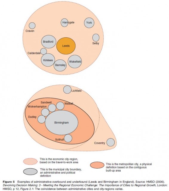
In England, a major attempt to co align the administrative boundaries with that of the functional urban regions was made in the 1960s by Derek Senior, a member of the Royal Commission on Local Government. His Minority Report advocated the establishment of 35 city-regions for England to form the upper tier, of a twotier structure, of local government with responsibility for strategic planning. However, the subsequent legislation for reform failed to implement these aspirations. Hence, there remains in Britain – as in many other developed countries – the problem of overbounding when the municipal boundary covers large tracts of rural land (see Leeds in Figure 5) and underbounding when the municipal boundary does not cover even the whole of their built up area (see Birmingham in Figure 5) let alone their functional hinterland.
As regards the city-region scale, the OECD survey (mentioned above) highlighted that in most of its member states there is no formal structure of governance operating at the level of functional urban regions. However, there has been a proliferation of voluntary intermunicipal cooperations at, loosely defined, city-regional level. Given the variable geometry of the city-regions, such voluntary collaborations provide a more flexible governance framework, capable of adapting to the rapidly changing dynamics of the city-region configurations. While such cooperative arrangements are motivated predominantly by the economic competitiveness agenda, they are also increasingly justified by the sustainable development agenda, and in particular the need for managing the environmental footprints of the cities over their hinterlands. More importantly, the environmental concerns as well as the recognition of the role of culture and identity are increasingly challenging the narrow, urban-centric, and economically driven definitions of the city-region. They are calling for a focus on the emerging relational dynamics of the city-region space.
Conclusion
The city-region has enjoyed a widespread resurgence in recent years as both an analytical and a political concepts. The focus of this article has been on the former, aiming to unpick the concept, trace its origin, and explore its evolution. Particular emphasis was placed on a critical review of the methodological approaches to the definition of the functional urban regions.
While in the last 60 years or so, many approaches have been adopted to define the city-region and map its boundaries, this article has shown that with a few exceptions, the dominant conception of the city-region has been urban-centric and economically driven. While the dominance of this econo urban perspective has historical roots, it has been further boosted by the apparent reemergence of the cities as the magnets for attracting population and economic activities and a prevailing policy framework based on competitive city-regionalism. It is argued that competitive cities create prosperous regions through a potential chain reaction which can follow from a high level commitment to strengthen a city's knowledge base as a launch pad for stronger economic performance and a distinctive external profile. While the evidence for such trickle down or ripple out effects is yet to be documented, this argument continues to frame the debate about the city-region in both analytical and political terms.
Analytically, it has fueled the dominance of the urban-centric and economically defined conception of the city-region, as clearly reflected in the interpretation of the city-region as a functional urban region and the top-down approach to define its boundaries. Politically, it has become the key justification for channeling policy attention, investments, and political powers toward the economic growth in major cities often at the expense of those parts of the regions which fall outside the cities' hinterlands.
Both the urban-centric and the economically driven view of the city-region have been challenged. The former is under increasing strain by the changing patterns of work, mobility, and lifestyle in rural areas, while the latter is questioned by a rising concern over the environmental footprint of the cities which affect their hinterlands and beyond. Despite this, there remains a key shortcoming in the current city-region agenda; that is, the disconnection between the conceptions of the city-region as an economic space from its conceptualization as an ecological space. Contemporary city-regions are key sites of consumption of environmental resources and production of waste. As such, they are engaged in not only economic exchanges and distributions of benefits, but also in ecological exchanges and distribution of risks and disbenefits. An illustrative example of this is the city-regional relationship based on the management of municipal waste which is based largely on generation of waste in the city and its disposal in its hinterland and beyond. Critical examination of how these changing ecological relationships may reshape our conceptions of the city-region and deepen our understanding of the emerging relational dynamics of the city-regional space will therefore make a valuable contribution to push the debate forward.