geomorphology
GEOMORPHOLOGY IS the study of landforms. Landforms are surface expressions of rocks, as are various features made by rivers, groundwater, waves and currents, winds, glaciers, and corals. Landforms come in all shapes and sizes. A DELTA, PLATEAU, VOLCANO, sinkhole, and beach are all landforms. Geomorphologists are geologists and physical geographers who specialize in the study of landforms.
Geomorphology has two general goals: 1) to explain how landforms vary from place to place; and 2) to develop theories about the origin and development of landforms. In order to achieve these goals, geomorphologists examine the nature of surface rocks and geologic processes, such as soil formation, weathering and EROSION, mass movements, and transportation and deposition of sediments. They use a wide range of techniques for data collection, including field, laboratory, and numerical techniques. Geomorphologic research aids in understanding the role that landform development plays in complex ecosystems. The findings also help prepare for and lessen impacts of hazardous geological events, such as landslides, FLOODS, beach erosion, and slope erosion. The following paragraphs summarize how geologic structure, PLATE TECTONICS, gradational processes, and time influence landform development. The four factors are interrelated so that their combined effects create an amazing variety of beautiful landforms for us to enjoy. The article concludes with a summary of how geomorphic theory in the United States evolved from a long tradition of geological and geographical research.
GEOLOGIC STRUCTURE
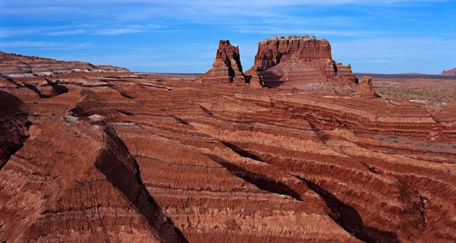
Landforms vary, in part, because of geologic structure. Geologic structure refers to the types and arrangement of materials that make up landforms. The materials are extremely diverse, ranging from sediments, such as finely textured clay deposits on a glacial lakebed, to massive large-grained rock that has crystallized from subsurface magma. There are three basic types of rock—igneous, sedimentary, and metamorphic—but each type has a wide variety of examples that differ according to their chemistry, texture, color, hardness, and so on. Common examples of sedimentary rocks are conglomerate, sandstone, siltstone, shale, and limestone.
Igneous rocks form when liquid magma (molten rock) cools and hardens. In the hardening, minerals take on their shape, or crystallize. There are two basic subcategories of igneous rocks—intrusive and extrusive. When the magma cools within Earth's crust, the rocks are of the intrusive igneous type. Granite is the most common rock of this type. When magma erupts onto Earth's surface, it cools outside the crust to become an extrusive igneous rock, or lava. Basalt is the most common type of lava.
Metamorphic rock forms when intense pressure and heat cause previously formed rocks (including other metamorphic rock) to deform or metamorphose. (Metamorphose in Latin means “to change form.”) Different rocks have their own metamorphic counterparts. Sedimentary rocks, such as limestone and dolostone, change to marble. Low-grade shale becomes sheets of slate, and sandstone turns to quartzite. Metamorphism may occur in igneous rocks as well. Granite recrystallizes to become banded gneiss (pronounced “nice”). Intense heat and pressure can also turn several kinds of sedimentary rocks or their metamorphic products into gneiss. Schist is a general term for a group of metamorphic rocks that forms under the most intense pressure and heat.
Earth materials exhibit even more variation in their arrangement. Joints divide rocks and internal forces (compression, tension, and shear) break them along faults, thrust them vast distances horizontally, or deform them by heat and pressure. Rocks may or may not be in layers. Sandstone has layers, but granite is a massive rock devoid of them. Layers of sedimentary rocks may be horizontal, tilted, or folded. Rocks also differ in the degree to which they yield to weathering and erosion processes. Hard rocks and soft rocks wear down to differing degrees. Ridges and peaks occur where hard rocks resist the work of weathering, rain, and streams. Valleys that separate the ridges are where rocks are weak. The rocks in valleys weather easily and streams wash their sediments away quickly.
The arrangement of most sediment varies according to a transporting agent (stream, wind, waves, or glacier). For example, meltwater discharging from a retreating glacier deposits stratified (water-sorted) layers of clay, silt, sand and gravel, but it also leaves behind piles of unstratified (unsorted) debris, ranging from clay to boulder-size materials. Like glacial meltwater, other transporting agents stratify or sort their deposits. Rivers form FLOODPLAINS and deltas; waves leave behind beaches and spits; and winds deposit sand dunes and loess (silt deposits). In contrast, layers of sediment left by corals and groundwater are in situ deposits (the sediments remain at their point of origin). Corals leave behind their skeletons to form limestone reefs, and groundwater forms various types of calcified deposits, such as stalagmites and stalactites.
PLATE TECTONICS
Geomorphologists have a big-picture view of the origin and general distribution of landforms through the study of plate tectonics. Plate tectonics refers to the movement and interaction of plates, which are sections of Earth's lithosphere (outer rock layer). Plate movements explain the origin and present distribution of expansive plains, plateaus, volcanoes, and mountain systems, as well as continents and ocean basins. Plates move slowly—generally less than 10 in (4 cm) per year. Nevertheless, their incremental movement over millions of years moves continents and opens and closes vast oceans. Driven by Earth's internal heat energy, tectonic plates have collided and separated several times to create and arrange rocks.
Since the 1960s, geomorphologists have become increasingly knowledgeable about how tectonic plates move and interact. They now understand that mountain- building activities (earthquakes, folding, faulting, and volcanism) occur more often at the edges of plates, where they come together, move apart, or slide past each other. The word tectonic is an apt name for these landform-building plates. In the Greek language, tectonic means “builder.” The most imposing mountain systems of today—HIMALAYAS, ALPS, and ANDES—are on the boundaries of converging plates. The mountains are primarily a result of folding. Volcanism and faulting, although they can have catastrophic results in folded mountainous areas, are of secondary importance to uplift caused by folding along convergent boundaries.
Volcanism plays a key role in building mountains from the seafloor. Where plates are converging beneath the sea, volcanic island arcs, such as JAPAN, the PHILIPPINES, and the Kuril and Aleutian islands, are forming. Where tectonic plates are moving apart on the seafloor, volcanism and faulting are building the world's largest mountain system—the mid-ocean ridge. Additionally, volcanism also forms volcanic islands where a plate passes over a magma plume that is in a stationary location in the mantle, which lies just below the moving lithosphere. The Hawaiian Islands are a classic example. Where plates slide past one another, strike-slip faulting and earthquakes are the dominant tectonic activities, such as in CALIFORNIA, where the San Andreas Fault Zone is so active.
Continental SHIELDS occur away from the edges of plates, where the Earth's surface has been subject to little or no tectonic activity. Shields are landscapes of low plateaus and hills. They are composed of ancient rocks that have escaped the destructive forces of plate movement. There are two types of shields—covered and exposed. Covered shields are under a cover of younger sedimentary layers. These strata accumulated at times when the shields subsided and shallow seas inundated the land. Rock-forming sediments from the land (clay, sand, and gravel) and from dead marine organisms covered the shields. Covered shields underlie portions of all of the continents.
For example, sedimentary rocks bury a shield in North America that lies between the Rockies and the Appalachian Highlands. Exposed shields occur where ancient continental rocks lie bare. An example of an exposed shield is the CANADIAN SHIELD of North America. Exposed shields also exist in Scandinavia (lowland SWEDEN and FINLAND), South America (Brazilian and Guiana highlands), Africa, AUSTRALIA, and INDIA.
GRADATIONAL PROCESSES
The wearing down of elevated areas also influences the nature of landforms from place to place. Relentless erosion by rivers and glaciers has worn down massive mountain ranges, leaving behind only bits and pieces of ancient bedrock. For example, plates collided to arrange rocks of the Appalachian Highlands in eastern North America, as well as highlands in the British Isles, southern GERMANY, CZECH REPUBLIC, and Scandinavia. These areas are actually the roots of mountains that were in the past as magnificent as the Rockies and Himalayas are today. The thickness and age of riverborne sediments that surround the base of these low mountains bear witness to great heights of former summits.
Gradation begins with physical and chemical weathering of rocks and other earth materials. Mass wasting (mass movement) transfers the weathered material downslope. Mass wasting processes include, creep, rock fall, solifluction, mudflows, earth flows, avalanches, and landslides. These processes result from the downslope pull of gravity. Gravity also pulls surface water and glacial ice downslope as they pick up and transport rock fragments produced by weathering. In addition to gravity, solar radiation is an energy source for gradation. It drives atmospheric circulation, which generates storms that produce major erosion agents—rain, meltwater from snow and ice, wind, and ocean waves. Kinetic energy of the erosion agents physically detaches, transports, and deposits sediments to form a variety of depositional landforms: streams deposit sediment to form ALLUVIAL FANS, floodplains and deltas; winds deposit sand dunes and loess; waves and currents form beaches; and retreating glaciers leave behind end moraines and outwash plains.
Weathering, mass movement, and erosion transfer sediments from elevated mountains and plateaus to low-lying sedimentary basins. Sedimentary deposits cover vast areas of continental lowlands, coastal plains, and submerged continental margins. Examples of sedimentary basins in North America are the U.S. Central Lowlands region—which includes the interior lowlands of OHIO, INDIANA, ILLINOIS, and IOWA; the Mississippi delta; and the Gulf Coastal Plain as well as the continental shelf beneath the Gulf of Mexico.
THE STUDY OF TIME
Landforms of the same type differ in appearance because they are in different states of change. Geomorphologists study change in landforms in terms of response times and restoration times. Change in a sandy beach is an example. The time a beach takes to adjust to erosion brought about by a storm's wave energy is its response time. The time required for restoration of the beach to its former shape is its restoration time.
At any given moment, a beach's shape reflects a balance between inputs and outputs of energy (waves) and mass (sand). Storm waves create a negative sediment budget by taking away large amounts of sand. Beaches respond to storm waves by becoming steeper and narrower, but they rebuild quickly after the storm subsides, when smaller waves bring in surplus sand. Such adjustments establish a new equilibrium between the landform (beach) and the process (wave action) affecting it.
The rates of response and restoration among landform types are wide-ranging. A beach typically responds to storms and restores itself in a matter of days, weeks or months, depending on the strength and frequency of storms.
In cases where restoration times are very long, the land may have “leftover” relicts of processes that are no longer active. For example, tectonic or climatic processes that cause the sea level to change may have ended tens of thousands or even hundreds of thousands of years ago. Consequently, coastal areas have relict forms of old shorelines, such as marine terraces and beach ridges. Relict landforms may require a million years or more of gradation by other processes for their removal. Removal of such relicts may never occur, as a resumption of tectonic activity and glaciations tend to interrupt restoration intervals of these magnitudes.
THEORIES OF LANDFORM EVOLUTION
U.S. geomorphology experienced spectacular growth from about 1890 to about 1950. American academics recognized W.M. DAVIS (1850–1934) as the leading specialist in the field during this period. Davis developed the technique of “explanatory description” of landscapes. He discouraged experimentation in processes of landscape evolution, because he felt the processes were too complex and landform types too varied. His methodology focused instead on describing three controlling factors of landscape change—structure, process, and time. Davis devised one of the earliest models of landscape evolution—the geographical cycle. The model posited that landscapes evolve through a sequential series of stages; each stage possesses an indicative set of landforms. Purely descriptive in origin, the observer was supposed to use the model to determine the stage of development of a particular landscape. Followers of Davis conducted few experimental studies on processes, for his descriptive system was deceptively adequate. Intuitive reasoning outpaced investigational proof during these early years.
World War II introduced improvements in aerial photography and new kinds of geomorphologic analysis. Accurate quantitative interpretation of beaches and coasts using aerial photographs were vital to military strategy during the war. Beach studies carried over after the war and led the trend in quantification and experimental verification. A concern for streams, the main suppliers of sand to beaches, was a logical extension of shoreline studies. Thus, the dynamics of weathering rates, stream erosion, and slope development quickly became a major focus of the new approach.
By the late 1960s, quantitative models had all but supplanted Davisian-type descriptive models. In subsequent decades, the role of climate in the genesis of landforms received more interest. Additionally, new technologies involving the study of the ocean floor validated the unifying theory of plate tectonics. Theoretical geomorphology in the United States has used the systems theory approach and has focused on developing quantitative models that replicate and predict geological processes. Geographic information systems, remote sensing, global positioning systems, and isotope dating have accelerated this trend.