Ground Water
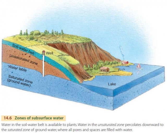
Water from precipitation can flow through the soil-water belt under the force of gravity. We call this flow percolation. Eventually, the percolating water reaches ground water. Ground water is the part of the subsurface water that fully saturates the pore spaces in bedrock, regolith, or soil (Figure 14.6). The top of the saturated zone is marked by the water table. Above the water table is the unsaturated zone in which water does not fully saturate the pores. This zone also includes the soil-water belt. Ground water moves slowly along deep flow paths and eventually emerges by seepage into streams, ponds, lakes, and marshes. In these places the land surface dips below the water table.
THE WATER TABLE
The water table can be mapped in detail, if there are many wells in an area, by plotting the water height in each well (Figure 14.8). Water percolating down through the unsaturated zone tends to raise the water table, while seepage into lakes, streams, and marshes draws off ground water and tends to lower its level. When there's a large amount of precipitation, the water table rises under hilltops or divide areas. During droughts, the water table falls.
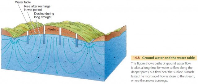
These differences in water table level are built up and maintained because ground water moves with extreme slowness through the fine chinks and pores of bedrock and regolith. Over time, the water table level tends to remain stable, and the flow of water released to streams and lakes balances the flow of water percolating down into the water table.
AQUIFERS
Clean, well-sorted sand—in beaches, dunes, or in stream deposits, for example—can hold an amount of ground water equal to about one-third of its bulk volume. So, sedimentary layers often control the storage and movement of ground water. Such layers are called aquifers. A bed of sand or sandstone is often a good aquifer. Clay and shale beds, by contrast, are relatively impermeable and are known as aquicludes.
Figure 14.9 shows ground water flowing in an aquifer that is sandwiched between two aquicludes. Because it can't easily penetrate into the aquicludes, this ground water is under pressure, so it flows freely from a well. This type of self-flowing well is an artesian well.

LIMESTONE SOLUTION BY GROUND WATER
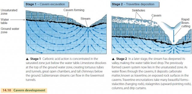
Carbonic acid—a weak acid produced from carbon d ioxide dissolved in water—slowly erodes limestone at the surface in moist climates. Similarly, limestone below the surface can be dissolved by ground water slowly flowing in the saturated zone, forming deep underground limestone caverns. Mammoth Cave in Kentucky and Carlsbad Caverns in New Mexico are examples of famous and spectacular caverns formed by solution. Figure 14.10 describes how caverns develop.
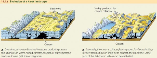
Sinkholes are surface depressions in a region of cavernous limestone. Some sinkholes are filled with soil washed from nearby hillsides, whereas others are steep-sided, deep holes. They develop where the limestone is more susceptible to solution weathering, or where an underground cavern near the surface has collapsed.
Landscapes where there are numerous sinkholes and no small surface streams are called karst. Figure 14.12 shows how a karst landscape develops. Important regions of karst or karst-like topography are the Mammoth Cave region of Kentucky, the Yucatan Peninsula, the Dalmatian coastal area of Croatia, and parts of Cuba and Puerto Rico. The karst landscapes of southern China and west Malaysia are dominated by steep-sided, conical limestone hills or towers.
GROUND WATER MANAGEMENT PROBLEMS
Rapid withdrawal of ground water has had a serious impact on the environment in many places. Vast numbers of wells use powerful pumps to draw huge volumes of ground water to the surface—greatly altering nature's balance of ground water discharge and recharge. The yield of a single drilled well ranges from as low as a few hundred liters or gallons per day in a domestic well to many millions of liters or gallons per day for a large industrial or irrigation well.
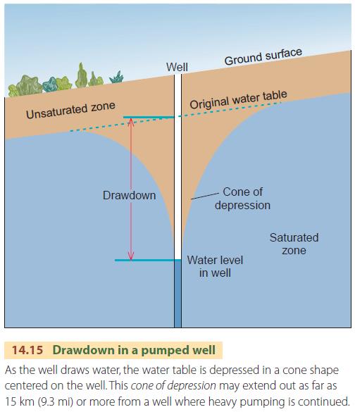
As water is pumped from a well, the level of water in the well drops. At the same time, the surrounding water table is lowered in the shape of a downward-pointing cone, which is called the cone of depression (Figure 14.15). The difference in height between the cone tip and the original water table is known as the drawdown. Where many wells are in operation, their intersecting cones will lower the water table. The water table is often depleted far faster than it is recharged by water infiltrating downward to the saturated zone. As a result, we are exhausting a natural resource that is not renewable except over very long periods of time.
An important environmental effect of excessive ground water withdrawal is subsidence of the ground surface. Venice, Italy, provides a dramatic example of this side effect. Venice was built in the eleventh century on low-lying islands in a coastal lagoon, sheltered from the ocean by a barrier beach. Underlying the area are some 1000 m (about 3300 ft) of sand, gravel, clay, and silt layers, with some layers of peat. Compaction of these soft layers has been going on gradually for centuries under the heavy load of city buildings. However, ground water withdrawal, which has been greatly accelerated in recent decades, has aggravated the condition. Many ancient buildings in Venice now rest at lower levels and have suffered severe damage as a result of flooding during winter storms on the adjacent Adriatic Sea. The problem of flooding during storms is aggravated by the fact that many of the canals of Venice still receive raw sewage, so that the floodwater is contaminated.
Most of the subsidence was caused by withdrawals of large amounts of ground water from nearby industrial wells, which has now stopped. At present, the rate of subsidence is only about 1 mm per year. However, the threat of flooding and damage to churches and other buildings of great historical value remains. Other cities that have suffered significant land subsidence include Bangkok and Mexico City.
Another major environmental problem is the contamination of wells by pollutants. One common source of these pollutants is the sanitary landfill, in which layers of waste are continually buried, usually by sand or clay available on the landfill site. This waste is situated in the unsaturated zone, where it reacts with rainwater that infiltrates the ground surface. Modern landfills are often designed with an impervious layer at the bottom, but if this layer fails, infiltrating water picks up a wide variety of chemical compounds from the waste and carries them down to the water table.
Salt water can also contaminate the water in coastal wells. Fresh water is less dense than salt water, so a layer of salt water from the ocean can lie below a coastal aquifer. When the aquifer is depleted, the level of salt water rises and eventually reaches the well from below, making the well unusable.