Himalayas
THE HIMALAYAN mountain region, located between INDIA and TIBET, has the world's highest peaks. It stretches from the INDUS RIVER in the west to the Brahamaputra in the east and has a length of 1,500 mi (2,414 km) and a width from 100 to 150 mi (161 to 241 km). Northwest of the Indus, the region of mountain ranges that extends to a junction with the Hindu Kush, south of the Pamir range, is known as Trans-Himalaya. Thus, the Himalayas represent the southern face of the great central elevated region—the plateau of Tibet—the northern face of which is buttressed by the Kunlun.
The physiography of the Himalayan mountain system can be classified into three parallel longitudinal zones:
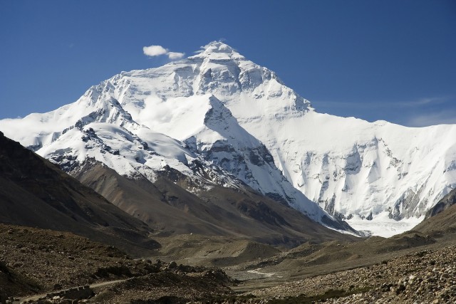
- The Great Himalayas. The main ranges, which lie in the north, rise above the snow line and have an average elevation of 20,000 ft (6,096 m) above sea level. They include the highest peaks of EVEREST (29,035 ft or 8,850 m), K2 (Godwin Austen) (28,251 ft or 8,611 m) and Kangchenjunga (28,168 ft or 8,586 m).
- The Lesser Himalayas. The middle ranges, which are closely related to and lie south of the Great Himalayas, form an intricate mountain system with an average height of 12,000 to 15,000 ft (3,657 m to 4572 m) above sea level.
- The Outer Himalayas. These comprise the Siwalik and other ranges, which lie between the Lesser Himalayas and the plains and have an average height of 3,000 to 4,000 ft (914 to 1,219 m) above sea level. The above classification is a useful generalization but does not represent the peculiar and complex features of the Himalayan system. These include:
- The Great Northern Watershed. On the north and northwest of Kashmir is the great water divide, which separates the Indus drainage area from that of the Yarkand and other rivers of Chinese Turkistan Sinkiang). It is not the great Himalayas but the Muztagh range which, with the Karakoram mountains, trends southward, forming a continuous mountain barrier and the true water divide west of the Tibetan plateau.
- Eastern Tibet. The Tibetan plateau, or Chang, breaks up at about the meridian of latitude 92 degrees E, to the east of which the affluent of the Tsangpo (the Dihang and subsequently the Brahamaputra) drain from wild, rugged mountain slopes. In this region are the sources of all major rivers of China and Myanmar (Burma).
It is now proved that Mount Everest, which appears from the Tibetan plateau as a single dominating peak, has no rival among Himalayan altitudes and is definitely the world's highest mountain. Everest was climbed by Sir Edmund Hillary and Tenzing Norgay in 1953. In Asia, there are 94 peaks exceeding 24,000 ft (7315 m); all but two are in the Himalayas or Karakoram. Much of the Himalayan area is still very imperfectly known geologically. The general structure resembles that of the Alps, with huge overfolds and nappes; all the main horizons from Precambrian to recent appear to be represented. A very large number of rock groups have been distinguished, described, and given local names. It is certain that during Mesozoic times, the Himalayan area was occupied by the great geosyncline, which coincided with the Tethys Sea or ocean basin. The sediments laid down in the Tibetan section of this great basin constitute the Tibetan zone, in which fossiliferous beds of Paleozoic and Mesozoic ages differ entirely in facies from those farther south. The second or Himalayan zone, which comprises the Great and Lesser Himalayas, is composed chiefly of metamorphic rocks and sediments that are generally unfossiliferous. It is believed that the elevation of this central axis took place mainly in Eocene-Oligocene times and that during this phase the important nummulitic limestones were deposited in a series of basins, notably in Ladakh. The main orogeny would seem to have resulted from the northward movement of the ancient block that is now seen in peninsular India and that underlies the Indo-Gangetic plain. Continued movement in Miocene times folded the nummulitic limestones; the final phase of the mountain building came in post-Pliocene times and has scarcely yet ceased—as the Assam earthquake bears witness—and folded intensely the Pliocene Siwalik sediments of the southern flank of the Outer Himalayas.
The uplift of the Himalayas was a gradual process protracted over a very long period and had a very marked effect upon the scenery, the topography, and the river system. The last is not consequent upon the structure, but the principle rivers were of an age anterior to the tertiary earth movements and the drainage is spoken of as antecedent. During the slow process of uplift, folding, and faulting, the rivers were able to keep, for the most part, to their original courses, although their erosive power was increased because of increased gradients.