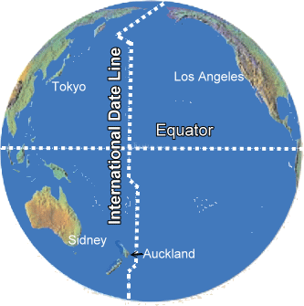
international date line
THE INTERNATIONAL date line (IDL) is the imaginary line on Earth slicing through the center of the PACIFIC OCEAN that separates two consecutive calendar days. Countries in the Eastern Hemisphere to the left of the line up to the Prime Meridian are always one day ahead of countries to the right of the line and west of the prime meridian. The international date line also marks 180 degrees of longitude. In spite of its name, the IDL has no force in any international treaty, law, or agreement. As a result, there have been numerous changes in the location of the line in the past, and today the line is not straight but jagged, its line in some parts extending as far as the 150 degrees longitude line.
The formation of the line has roots in a problem called the circumnavigator's paradox, in which travelers going westward would find upon returning home that one more day than they thought had elapsed, and eastward travelers found that they seemed to take one day less than they recorded upon reaching their destination. The first known mention of the circumnavigator's paradox was in the Taqwin al-Buldan, written by the Syrian prince-navigator Abu 'l-Fida between 1273 and 1331.
The circumnavigator's paradox was noted by explorers of some famous journeys, including in 1519 during the first circumnavigation of the globe led by Ferdinand Magellan and during Francis Drake's westward circumnavigation of the globe in 1577–80. The problem also fascinated the world of fiction; the idea of gaining time going eastward was crucial for Jules Verne's fictional character Phileas Fogg in the classic Around the World in Eighty Days.
The international date line can be placed anywhere on the world, but it is most conveniently located 180 degrees from the prime or zero meridian, found at Greenwich, England. The line is also most convenient passing through only water, as was suggested by one of the early advocates of the new meridian, Erik de Put. It was not until the 1800s that new strides were taken to set a new date line, but even then, authorities were skeptical about the use of such a line, especially since countries for a long time could not even agree on a common prime meridian.
The international date line has not been static over time, its shift in time and place owing to local interests and political affiliations. One notable shift was the Philippine adjustment, where prior to the present position, the Philippine Islands had been to the east of the line. This was because Spanish travelers used to journey to the then-Spanish colony via South America, so it was convenient for them not to have to adjust their dates when they reached the PHILIPPINES. During the early 1840s the commercial interests of the Philippine Islands turned increasingly away from South America (which had become independent from SPAIN) and toward trade with the nearby Malay Peninsula, the Dutch East Indies, AUSTRALIA, and CHINA. In 1844, in order to facilitate the growth of these new trading and communication links, the American day reckoning was abolished in favor of the Asian day reckoning.
Other significant changes include ALASKA, which was to the west of the International Date Line when Alaska belonged to RUSSIA, because most travelers arrived there by way of SIBERIA. When the UNITED STATES bought Alaska in 1867 the line was moved to the west of it. The most recent change was in 1995, when KIRIBATI was moved to the east of the line so that the entire nation would be on the same side of the line and the same day.