Kola Peninsula
THE KOLA PENINSULA IS one of RUSSIA's regions of great contrast: at once an area of stark natural beauty and of severe ecological danger; rich in minerals, but one of Russia's poorest regions; and an area that is both closely linked to the concerns of Western Europe and strictly isolated from the outside world. The peninsula is the westernmost of Russia's numerous peninsulas that jut out into its Arctic seas and has provided strategic sheltered harbors for Russia's northern fleets since the 18th century.
Geographically, the Kola Peninsula forms the heel of the Scandinavian landmass, pointing in the opposite direction from the other three Scandinavian projections that form NORWAY, SWEDEN, and FINLAND. The peninsula covers roughly 50,000 square mi (128,000 square km), separating the White Sea from the much larger Barents Sea to the north. Its coasts on these two seas differ sharply: along the White Sea and its tributary, Kandalaksha Bay, the coast is low and smooth; the coast along the Barents Sea, called the Murman Coast, is mountainous and heavily indented. These coastal mountains form the easternmost extension of the Scandinavian ranges that form the backbone between Norway and Sweden.
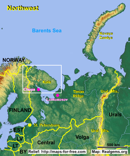
The center of the peninsula is a granite and gneiss plateau, with several large lakes, and is covered with tundra in the north and forests in the south. The plateau rises to form some moderate peaks, the highest reaching 3,930 ft (1,191 m). This mountainous region is rich in minerals. Several large rivers drain the peninsula to the north or south, including the Tuloma and the Kola. The Kola River connects the north coast and the region's chief city of Murmansk to the White Sea via Lake Imandra and a short canal. This passage allows ships from Russia's main northern port, Arkhangelsk, on the White Sea, to reach the Murman Coast, one of the few Arctic coasts to remain unfrozen throughout the year.
Because these waters offer Russia's only year-round access to the ATLANTIC OCEAN, it has served as home to Russia's Northern Fleet since the 19th century. Murmansk was the site of a 1918 Allied troop landing and an important base in World War II. It then became a major center for the Soviet Union's nuclear submarine program. The numerous fjords between Murmansk and the Norwegian border (less than 60 mi or 100 km away) are stocked with naval and air bases, and have thus provided a source of heightened tensions with NORTH ATLANTIC TREATY ORGANIZATION (NATO) member Norway. NATO maintains numerous early warning systems on its side of the border, keeping an eye on the stocks of nuclear weapons kept on the Kola Peninsula since the 1950s.
The decay of Soviet power and the collapse of the Soviet Union have left behind about 155 nuclear submarines in the fjords of the Kola Peninsula, about half of which are unfit for use. Most of these are even unfit to be moved or dismantled, creating one of the world's largest nuclear waste problems. It is estimated that roughly two-thirds of the world's nuclear waste has been dumped off the peninsula, not counting that which is sitting in rickety ships near Murmansk. The nearby Kola Nuclear Power Station provides about 60 percent of the region's power, but has been declared one of the world's least safe reactors, having come close to a meltdown as recently as 1993.
The Russian government continues to restrict travel to and from this region, but its heavily impoverished population looks to Norway and Finland for aid rather than to Moscow. The western part of the peninsula forms part of Lapland, the homeland of the seminomadic Saami people that stretches across northern Norway, Sweden, and Finland. The Saami (or Lapps) live in the southeastern parts of the peninsula, while areas in the west are populated by Karelians, close kin to Finns. The languages of both Saami and Karelians are related to other Uralic languages, whose people live elsewhere in northern Russia.