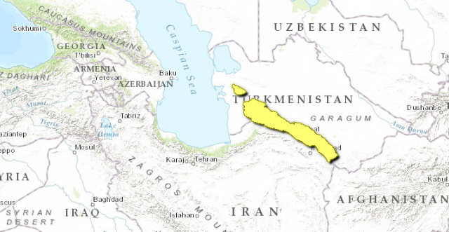
Kopet Mountains
THE SMALL RANGE of mountains that forms the northern boundary of IRAN with TURKMENISTAN is known as the Kopet Dag, or Kopet Mountains (Kopetdag in Turkmen). The range stretches for 400 mi (645 km), from a point near the CASPIAN SEA to the Harirud River in the east, which flows from northwestern AFGHANISTAN to a desert delta in southeastern Turkmenistan (where it is called the Tejen River).
The highest point in the range is the Kuh-e Quchan (10,466 ft or 3,191 m), in the southern part of the range in Iran. The highest point in the northern range, which forms the border between the two countries, is Mount Shahshah (9,600 ft or 2,912 m), which looms over the city of Ashgabat to the north.
POPULATION GEOGRAPHY
Most of the population of Turkmenistan is clustered in towns and cities in the foothills of the Kopet Dag, including Ashgabat, its largest city and capital. The northern and southern ranges are divided by the valley of the Atrak River (entirely in Iran, until it forms the border west of the Kopet Dag ranges) and the largest city of the Iranian province of Khorasan, Mashhad. Many of the local inhabitants are semi-nomadic sheepherders, while others cultivate the region's fruit specialties in the rich LOESS foothills and the mountain gorges: pomegranates, plums, figs, almonds, walnuts and pistachios, plus plants known for centuries for their medical properties, aromas, and dyes. This cultivation is aided by the fact that the mountains receive more rain than any other part of Turkmenistan.
The isolation of these mountains by deserts on both sides has produced a large variety of flora and fauna that are found nowhere else, a fact that has led the local Turkmen government to create the Syunt-Hasardag Nature Reserve—over 74,000 acres (30,000 hectares)—in the southwest portion of the range. The reserve is home to the region's most famous wildlife, its hunting birds, including the golden eagle, black griffin, and desert kestrel. Other animals include leopards, boars and desert hyenas.
The mountains are tectonically active and frequently prone to earthquakes—the most devastating in recent history was in 1948, which completely destroyed Ashgabat. The mountains have served as a barrier for various empires centered on the Iranian plateau from invasions from the north but also as a meeting point between Central and South Asian civilizations, as the terminus (end point) of the Great SILK ROAD from CHINA to Persia.