Kyushu Mountains
THE KYUSHU MOUNTAINS form the high, elevated central portion of the Japanese island of Kyushu, the southernmost of JAPAN's four main islands. Running roughly diagonally across the island, northeast to southwest, they cut Kyushu into a northern and southern sector. These sectors differ markedly from each other in many ways, from geology to economics: the north is urban and industrial, while the south is agricultural and poorer. The central part of the range has peaks over 3,300 ft (1,000 m), with the highest elevations at the northern end, overlooking the Aso ash and lava plateau. Mount Aso is the world's largest volcano and last erupted in January 2004, highlighting the range's status as one of the most geologically active places on the planet, with numerous volcanoes and hot springs, such as the famous resort at Beppu.
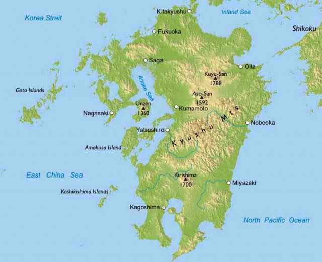
The island of Kyushu lies at the intersection of three tectonic plates. The core of the island was formed where the Seinan mountain arc (coming south from the island of Honshu) intersects with the mostly submerged arc of the Ryukyu Islands, which penetrates Kyushu from the south. The topography is broken up into narrow valleys cutting through steep slopes. The Kuma River is the chief waterway and flows northward into a gorge famous among trekkers. Restricted lowland area means that there has been a high degree of terracing for rice cultivation, though the population in general is rather sparse compared to the rest of Japan.
Orange groves and forestry dominate the local economy, though there has been recent growth in mineral processing industries (gold, copper, petroleum) on the eastern coast, where the ruggedness of the coast— with mountains descending directly into the sea in places—has created small protected natural harbors
with relatively deep waters. The Ono River provides the needed water for these factories, as well as hydroelectric power.