Landforms and Rock Structure
Over the world's vast land area, you'll see many types of rock and rock structures. In many cases, rock structure controls the locations of uplands and lowlands, as well as the routes of streams and rivers.
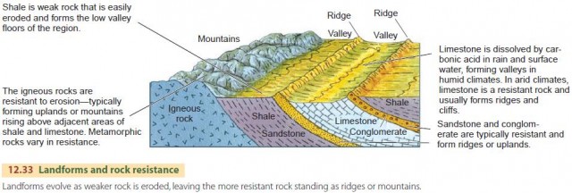
Rock structure affects landforms because different types of rocks are worn down by erosion at different rates. Some rock types are easily eroded, while others are more resistant. For example, we usually find weak rocks under valleys and strong rocks under hills, ridges, and uplands (Figure 12.33). Among rock types, igneous rocks, sandstone, and conglomerate resist erosion, while claystone, mudstone, and shale erode easily. In humid climates, limestone is a weak rock, but in dry climates, it resists erosion.
LANDFORMS OF HORIZONTAL STRATA AND COASTAL PLAINS
Vast areas of the ancient continental shields are covered by thick sequences of horizontal sedimentary rock layers. These strata were deposited in shallow inland seas at various times in the 600 million years following the end of Precambrian time. After crustal uplift, these areas became continental surfaces.
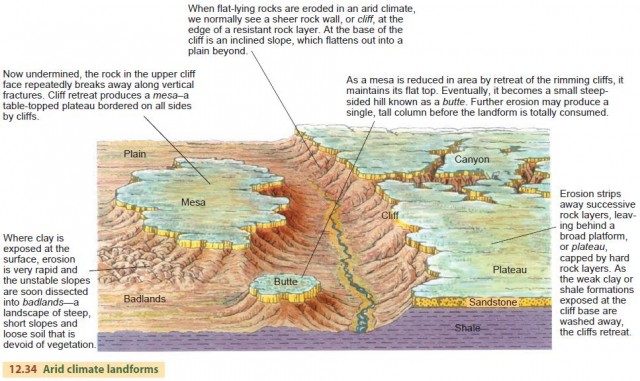
In arid climates, vegetation is sparse, and weathered rock and soil cover much of the land surface. When rainfall occurs, it is often in the form of torrential downpours from thunderstorms. As the water runs off, it carries sediment downslope, producing erosion.
The intense runoff rapidly carves small stream basins that rapidly dissect the landscape into distinctive landforms. Figure 12.34 shows the landforms that result in an arid landscape of flat-lying strata—cliffs, plateaus, mesas, buttes, and badlands.
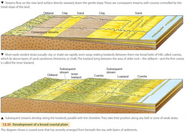
Coastal plains are found along passive continental margins that are largely free of tectonic activity. Below these plains, the strata are nearly horizontal, sloping gently toward the ocean. Often these sediments are unconsolidated and offer little resistance to erosion, with clay forming lowlands and sandy ridges forming lines of low hills called cuestas (Figure 12.35).
As the sediments first emerge, consequent streams drain the gentle slope, heading straight to the ocean. As the belts of less resistant strata erode, subsequent streams develop and connect to the consequent streams. The coastal plain of the United States is a major geographical region, ranging in width from 160 to 500 km (about 100 to 300 mi) and extending for 3000 km (about 2000 mi) along the Atlantic and Gulf coasts.
LANDFORMS OF WARPED ROCK LAYERS
In the last section we looked at cases where the sedimentary rock layers are horizontal or gently sloping. But in some regions, rock layers may be warped upward or downward. We saw an example of this earlier in the chapter, when we looked at fold belts, in which rock layers are folded to form anticlines and synclines.
Another distinctive land-mass type is created when strata are forced upward into a dome. Sedimentary domes can be found in various places within the covered shield areas of the continents. Igneous intrusions of rocks at great depths may be responsible for some domes. For others, upward motion on deep faults may have been the cause. Figure 12.36 shows how domes are eroded over time to create hogback ridges and circular valleys.
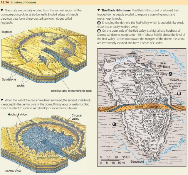
An example of a large and rather complex dome is the Black Hills dome of western South Dakota and eastern Wyoming (Figure 12.36). At the center of the structure is a mountainous core of upwarped intrusive and metamorphic rocks revealed by erosion. The region is a very attractive summer resort, with richly forested mountains and beautiful open parks in the surrounding valleys. In the northern part of the central core, there are valuable ore deposits.
At the historic town of Lead is the fabulous Homestake Mine, one of the world's richest gold-producing mines. The west-central part of the Black Hills consists of a limestone plateau deeply carved by streams. The plateau represents one of the last remaining sedimentary rock layers to be stripped from the core of the dome.
METAMORPHIC BELTS
Earlier in the chapter we saw how fold belts produce a ridge-and-valley landscape when they have been eroded. If the strata have been tightly folded and altered into metamorphic rocks during a continental collision, we'll still get a landscape with a strong grain of ridges and valleys. But because the strata have been exposed to variations in pressure and have been fractured and faulted in different ways, the ridges and valleys won't be as sharp or as straight as in belts of open folds. Even so, the resistant rocks will form highlands and ridges, while the weak rocks will form lowlands and valleys.
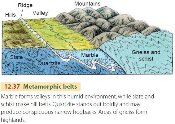
Figure 12.37 shows typical erosional forms associated with parallel belts of metamorphic rocks, such as schist, slate, quartzite, and marble.
Parts of New England, particularly the Taconic and Green Mountains of eastern New York, western Massachusetts, and Vermont, illustrate the landforms eroded on an ancient metamorphic belt. The larger valleys trend north and south and are underlain by marble. These are flanked by ridges of gneiss, schist, slate, or quartzite.
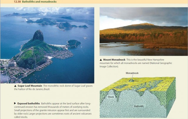
EXPOSED BATHOLITHS AND MONADNOCKS
Batholiths are huge bodies of intrusive igneous rock, formed deep below the Earth's surface. Some of these batholiths are eventually uncovered by erosion and appear at the surface. Because batholiths are typically composed of resistant rock, they are eroded into hilly or mountainous uplands. A good example is the Idaho batholith, a granite mass exposed over an area of about 40,000 sq km (about 16,000 sq mi)—a region almost as large as New Hampshire and Vermont combined. Another example is the Sierra Nevada batholith of California, which makes up most of the high central part of that great mountain block. The Canadian shield includes many batholiths, large and small.
Sugar Loaf Mountain, which rises above the city of Rio de Janeiro, Brazil, is a small granite dome-like projection of a batholith that underlies the area. Such granite projections are often found surrounded by ancient metamorphic rocks into which the granite was intruded.
Figure 12.38 shows the features created when batholiths are exposed at the surface. We call isolated mountains or hills produced in this way monadnocks. The name is taken from Mount Monadnock in southern New Hampshire.