Low-Latitude Climates (Group I)
The low-latitude climates lie for the most part between the Tropics of Cancer and Capricorn, occupying all of the equatorial zone (10° N to 10° S), most of the tropical zone (10–15° N and S), and part of the subtropical zone. The low-latitude climate regions include the equatorial trough of the intertropical convergence zone (ITCZ), the belt of tropical easterlies (northeast and southeast trades), and large portions of the oceanic subtropical high-pressure belt. There are four low-latitude climates: wet equatorial, monsoon and trade-wind coastal , wet-dry tropical, and dry tropical . We will now look at each one in detail.
WET EQUATORIAL CLIMATE 1 (KOPPEN: Af )
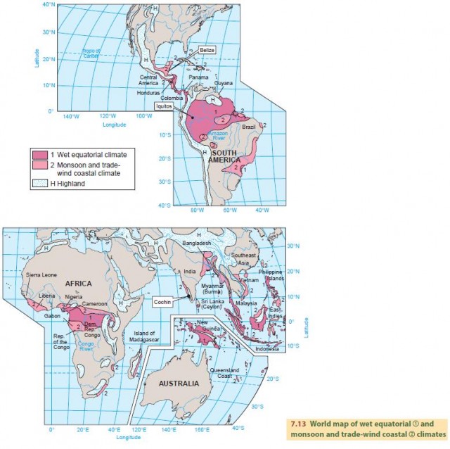
Figure 7.13 shows the world distribution of the wet equatorial climate 1 . This climate region lies between 10° N and 10° S, and includes the Amazon lowland of South America, the Congo Basin of equatorial Africa, and the East Indies, from Sumatera to New Guinea.
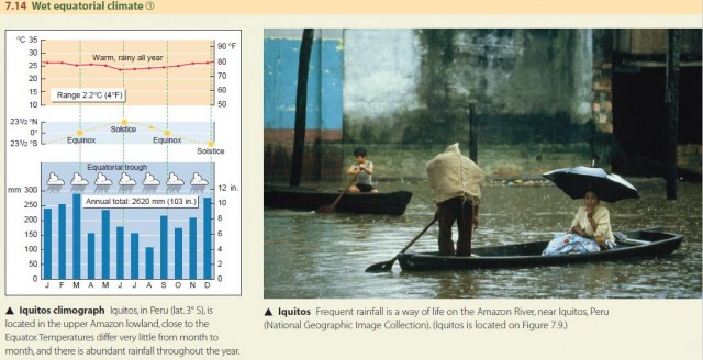
The wet equatorial climate is controlled by the ITCZ and is dominated by warm, moist maritime equatorial (mE) and maritime tropical (mT) air masses that yield heavy convective rainfall. There's a large amount of precipitation every month, and the annual total often exceeds 2500 mm (about 100 in.). But there is a seasonal rainfall pattern, with heavier rain when the ITCZ migrates into the region. Temperatures are uniform throughout the year, with mean monthly and mean annual temperatures close to 27°C (81°F). Typically, mean monthly air temperature will range between 26° and 29°C (79° and 84°F) for stations at low elevation in the equatorial zone (Figure 7.14).
THE MONSOON AND TRADE-WIND COASTAL CLIMATE (KOPPEN: Af, Am)
Like the wet equatorial climate , the monsoon and tradewind coastal climate has abundant rainfall. But here, the rainfall always shows a strong seasonal pattern. In the high-Sun season, the ITCZ is nearby, so monthly rainfall is greater. In the low-Sun season, when the ITCZ has migrated to the other hemisphere, the region is dominated by subtropical high pressure, so there is less monthly rainfall. The climate occurs between 5° and 25° N and S.
As its name suggests, this climate type is produced by two different situations. On trade-wind coasts, rainfall is produced by moisture-laden maritime tropical (mT) and maritime equatorial (mE) air masses. They are moved onshore onto narrow coastal zones by trade winds or by monsoon circulation patterns. As the warm, moist air passes over coastal hills and mountains, the orographic effect touches off convective shower activity.
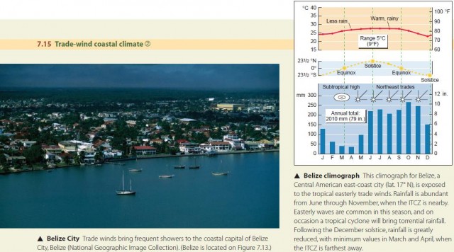
Easterly waves, which are more frequent when the ITCZ is nearby, also intensify shower activity. The east coasts of land masses experience this trade-wind effect because the trade winds blow from east to west. Trade-wind coasts are found along the east sides of Central and South America, the Caribbean Islands, Madagascar (Malagasy), Southeast Asia, the Philippines, and northeast Australia. Figure 7.15 is a climograph for the city of Belize, in the Central American country of Belize.
In the Asiatic summer monsoon, the monsoon circulation also brings mT air onshore (Figure 7.16). But the onshore monsoon winds blow from southwest to northeast, so it is the western coasts of land masses that are exposed to this moist airflow. Western India and Myanmar (formerly Burma) are examples. Moist air also penetrates well inland in Bangladesh, providing very heavy monsoon rains.
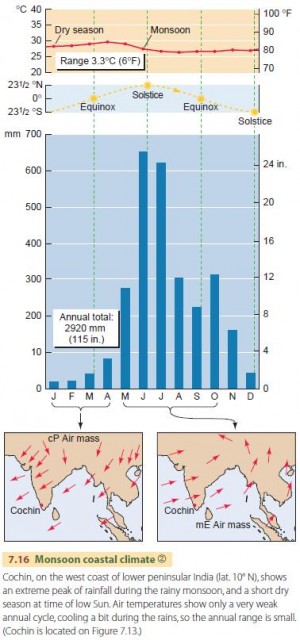
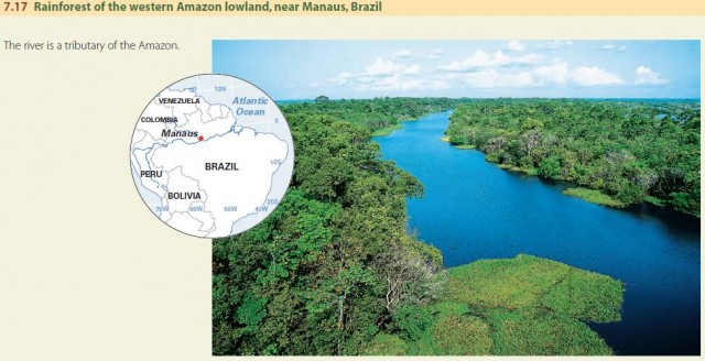
Temperatures in the monsoon and trade-wind coastal climate are warm throughout the year. Warmest temperatures occur in the high-Sun season, just before the ITCZ brings clouds and rain, while minimum temperatures are at the time of low Sun. Our first two climates—wet equatorial and monsoon and trade-wind coastal —create a special environment—the low-latitude rainforest (Figure 7.17). In the rainforest, temperatures are uniformly warm through the year and rainfall is high. Streams flow abundantly most of the year, and the riverbanks are lined with dense forest vegetation.
THE WET-DRY TROPICAL CLIMATE (KOPPEN: Aw, Cwa)
As we move farther poleward, the seasonal cycles of rainfall and temperature become stronger, and the monsoon and trade-wind coastal climate grades into the wet-dry tropical climate.
The wet-dry tropical climate has a very dry season at low Sun and a very wet season at high Sun. During the low-Sun season, when the equatorial trough is far away, dry continental tropical (cT) air masses prevail. In the high-Sun season, when the ITCZ is nearby, the climate is dominated by moist maritime tropical (mT) and maritime equatorial (mE) air masses. Cooler temperatures in the dry season give way to a very hot period before the rains begin.
Figure 7.18 shows the global distribution of the wet-dry tropical climate . This climate region lies between 5° and 20° N and S in Africa and the Americas, and between 10° and 30° N in Asia. In Africa and South America, the climate occupies broad bands poleward of the wet equatorial 1 and monsoon and trade-wind coastal climate . Because these regions are farther away from the ITCZ, less rainfall is triggered by the ITCZ during the rainy season, and in the low-Sun season subtropical high pressure dominates more strongly.
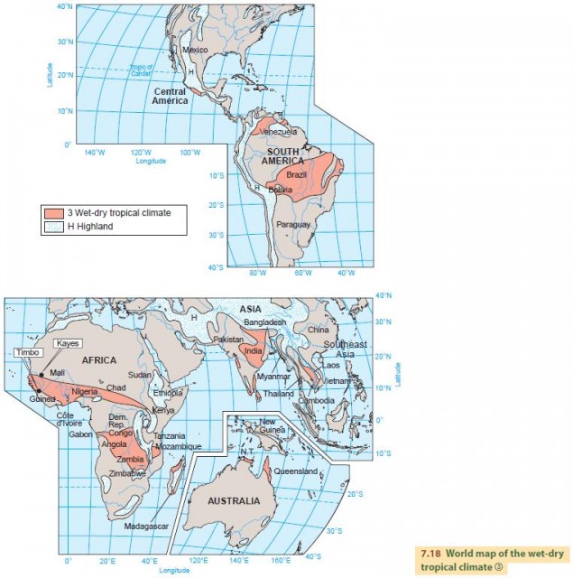
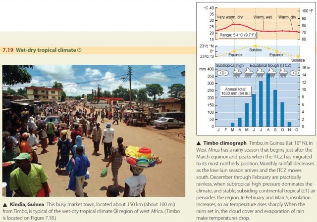
In central India and Vietnam, Laos, and Cambodia, the regions of wet-dry tropical climate are somewhat protected by mountain barriers from the warm, moist mE and mT airflows provided by trade and monsoon winds. These barriers create a rain shadow effect, so that even less rainfall occurs during the rainy season and the dry season is drier still. Figure 7.19 is a climograph for Timbo, Guinea, at lat. 10° N in West Africa.
The native vegetation of the wet-dry tropical climate must survive alternating seasons of very dry and very wet weather. This situation produces a savanna environment of sparse vegetation. In the low-Sun season, river channels that are not fed by nearby moist mountain regions are nearly or completely dry. In the high-Sun season, they fill with runoff from abundant rains. When the rains of the high-Sun season fail, there can be devastating famine.
THE DRY TROPICAL CLIMATE (KOPPEN: BWh, BSh)
The dry tropical climate is found in the center and east sides of subtropical high-pressure cells. Here, air descends and warms adiabatically, inhibiting condensation, so rainfall is very rare and occurs only when unusual weather conditions move moist air into the region. Skies are clear most of the time, so the Sun heats the surface intensely, keeping air temperatures high. During the high-Sun period, heat is extreme. During the low-Sun period, temperatures are cooler. Given the dry air and lack of cloud cover, the daily temperature range is very large.
The driest areas of the dry tropical climate are near the Tropics of Cancer and Capricorn. If you travel from the Tropics toward the Equator, rainfall increases. At first, we encounter regions that have short rainy seasons when the ITCZ is near, until finally the climate grades into the wet-dry tropical type.
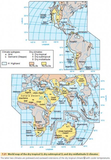
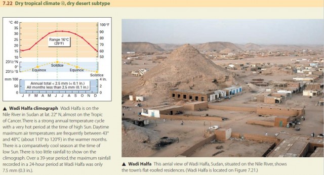
Figure 7.21 shows the global distribution of the dry tropical climate . Nearly all of the dry tropical climate lies between lat. 15° and 25° N and S. The largest region is the Sahara–Saudi Arabia–Iran–Thar desert belt of North Africa and southern Asia, which includes some of the driest regions on Earth. Another large region is the desert of central Australia. The west coast of South America, including portions of Ecuador, Peru, and Chile, also exhibits the dry tropical climate . But temperatures there are moderated by a cool marine air layer that blankets the coast. Figure 7.22 is a climograph for a dry tropical station, Wadi Halfa, in Sudan in the heart of the North African desert.
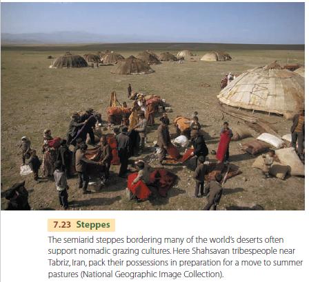
The Earth's desert landscapes are actually quite varied. Although these dry deserts are largely extremely arid (a), there are broad zones at the margins that are semiarid (s). These steppes have a short wet season that supports the growth of grasses on which animals (both wild and domestic) graze (Figure 7.23).
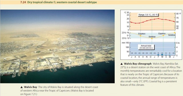
There is an important variation of the typical dry tropical climate in the narrow coastal zones along the western edge of continents. These regions are strongly influenced by cold ocean currents and the upwelling of deep, cold water, just offshore. The cool water moderates coastal zone temperatures, reducing the seasonality of the temperature cycle. Figure 7.24 shows a good example of this, in Walvis Bay, in Namibia.