Midlatitude Climates (Group II)
The midlatitude climates almost fully occupy the land areas of the midlatitude zone and a large proportion of the subtropical latitude zone. They also extend into the subarctic latitude zone, along the western fringe of Europe, reaching to the 60th parallel. Unlike the lowlatitude climates, which are about equally distributed between northern and southern hemispheres, nearly all of the midlatitude climate area is in the northern hemisphere. In the southern hemisphere, the land area poleward of the 40th parallel is so small that the climates are dominated by a great southern ocean.
In the northern hemisphere, the midlatitude climates lie between two groups of very unlike air masses, which interact intensely. Tongues of maritime tropical (mT) air masses enter the midlatitude zone from the subtropical zone, where they meet and conflict with tongues of maritime polar (mP) and continental polar (cP) air masses along the polar-front zone.
The midlatitude climates include the poleward halves of the great subtropical high-pressure systems and much of the belt of prevailing westerly winds. As a result, weather systems, such as traveling cyclones and their fronts, characteristically move from west to east. This global airflow influences the distribution of climates from west to east across the North American and Eurasian continents. There are six midlatitude climate types. They span the range from those with strong wet and dry seasons to those with uniform precipitation.
Temperature cycles for these climate types are also quite varied. We will now turn to each climate type in more detail.
(KOPPEN: BWh, BWk, BSh, BSk)
The dry subtropical climate is simply a poleward extension of the dry tropical climate . It is caused by somewhat similar air-mass patterns, but the annual temperature range is greater for the dry subtropical climate. The lower latitude portions have a distinct cool season, and the higher latitude portions have a cold season. The cold season occurs at a time of low Sun and is caused in part by the invasion of cold continental polar (cP) air masses from higher latitudes. Midlatitude cyclones occasionally move into the subtropical zone in the low-Sun season, producing precipitation. There are both arid (a) and semiarid (s) subtypes in this climate.
The dry subtropical climate is found in a broad band of North Africa, connecting with the Near East. Southern Africa and southern Australia also contain this climate. A band of dry subtropical climate occupies Patagonia, in South America. In North America, the Mojave and Sonoran deserts of the American Southwest and northwest Mexico are of this type. Figure 7.25 is a climograph for Yuma, Arizona, a city within the arid subtype of the dry subtropical climate .
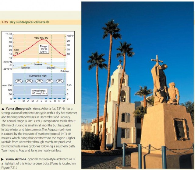
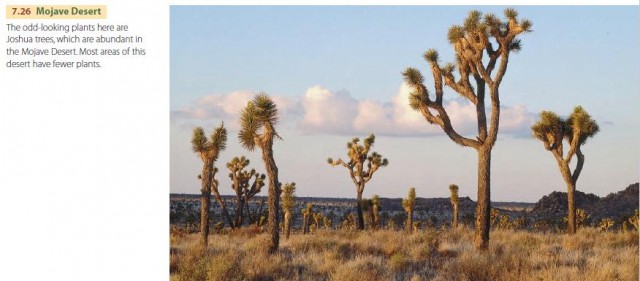
The dry subtropical climate environment is similar to that of the dry tropical climate . Both are very dry, and the boundary between these two climate types is gradational. But if we travel northward in the subtropical climate zone of North America, arriving at about 34° N in the interior Mojave Desert of southeastern California, we encounter environmental features that are significantly different from those of the low-latitude deserts of tropical Africa, Arabia, and northern Australia. Although the great summer heat is comparable to the Sahara Desert, the low Sun brings a winter season unseen in the tropical deserts. Here, cyclonic precipitation can occur in most months, including the cool low-Sun months. Desert plants and animals have adapted to the dry environment (Figure 7.26).
THE MOIST SUBTROPICAL CLIMATE (KOPPEN: Cfa)
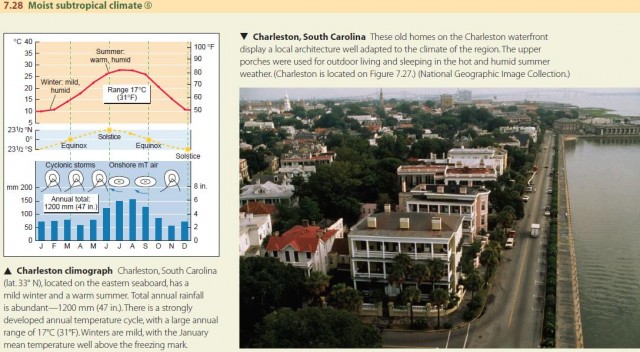
The moist subtropical climate (Figure 7.27) is found on the eastern sides of continents between lat. 20° and 35° N and S. In South America, it includes parts of Uruguay, Brazil, and Argentina. In Australia, it consists of a narrow band between the eastern coastline and the eastern interior ranges. Southern China, Taiwan, and southernmost Japan are included, as is most of the Southeast of the United States, from the Carolinas to east Texas.

Circulation around subtropical high-pressure cells provides a flow of warm, moist air onto the eastern side of continents, as we have discussed. This flow of maritime tropical (mT) air dominates the moist subtropical climate . There is abundant rainfall in the summer, much of which is convective. Occasional tropical cyclones add to this summer precipitation. In Southeast Asia, this climate is characterized by a strong monsoon effect, with much more rainfall in the summer than in the winter. Summer temperatures are warm, with persistent high humidity.
There is also plenty of winter precipitation, produced in midlatitude cyclones. Continental polar (cP) air masses frequently invade these climate regions in winter, bringing spells of subfreezing weather. But no winter month has a mean temperature below 0°C (32°F). Figure 7.28 shows a climograph for Charleston, South Carolina. The native vegetation of the moist subtropical climate is forest of several different types.
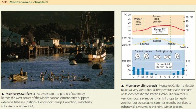
THE MEDITERRANEAN CLIMATE (KOPPEN: Csa, Csb)
The Mediterranean climate is unique because it has a wet winter and a very dry summer. This is because the climate is located along the west coasts of continents, just poleward of the dry, eastern side of the subtropical highpressure cells. When the subtropical high-pressure cells move poleward in summer, they enter the Mediterranean climate region. Dry continental tropical (cT) air then dominates, producing the dry summer season. In winter, the moist mP air mass invades with cyclonic storms and generates ample rainfall.
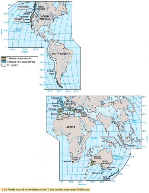
A global map of the Mediterranean climate is shown in Figure 7.30. It is found between lat. 30° and 45° N and S. In the southern hemisphere, it occurs along the coast of Chile, in the Cape Town region of South Africa, and along the southern and western coasts of Australia. In North America, it is found in central and Southern California. In Europe, this climate type surrounds the Mediterranean Sea, giving the climate its distinctive name.
The Mediterranean climate spans arid to humid climates, depending on location. Generally, the closer an area is to the tropics, the stronger the influence of subtropical high pressure will be, and thus the drier the climate. The temperature range is moderate, with warm to hot summers and mild winters. Coastal zones between lat. 30° and 35° N and S, such as Southern California, show a smaller annual range, with very mild winters. Figure 7.31 shows a climograph for Monterey, California.
The native vegetation of the Mediterranean climate environment is adapted to survive through the long summer drought. Shrubs and trees are typically equipped with small, hard, or thick leaves that resist water loss through transpiration. These plants are called sclerophylls; the prefix scler, from the Greek for “hard,” is combined with phyllo, which is Greek for “leaf.”
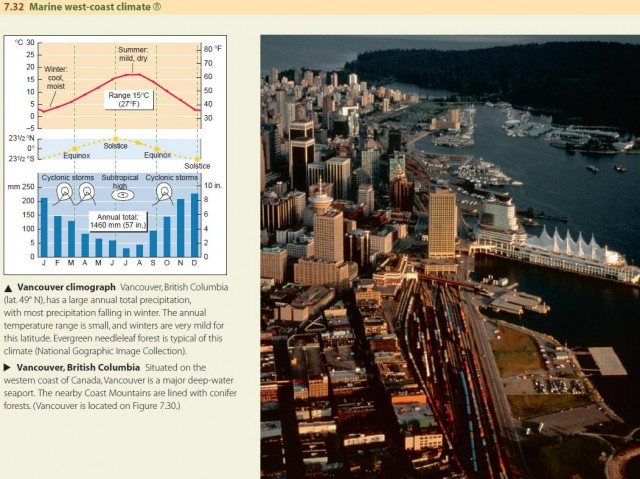
THE MARINE WEST-COAST CLIMATE (KOPPEN: Cfb, Cfc)
The marine west-coast climate occupies midlatitude west coasts. These locations receive the prevailing westerlies from a large ocean, and there are frequent cyclonic storms involving cool, moist mP air masses. Where the coast is mountainous, the orographic effect causes large amounts of precipitation annually. Precipitation is plentiful in all months, but there is often a distinct winter maximum. In summer, the rainfall is reduced because subtropical high pressure extends poleward into the region. The annual temperature range is comparatively small for midlatitudes. The marine influence keeps winter temperatures milder than at inland locations at equivalent latitudes.
In North America, the marine west-coast climate occupies the western coast from Oregon to northern British Columbia. In Western Europe, the British Isles, Portugal, and much of France fall under this climate. In the southern hemisphere, it includes New Zealand and the southern tip of Australia, as well as the island of Tasmania and the Chilean coast south of 35° S. The general latitude range of this climate is 35° to 60° N and S. Figure 7.32 shows a climograph for Vancouver, British Columbia.
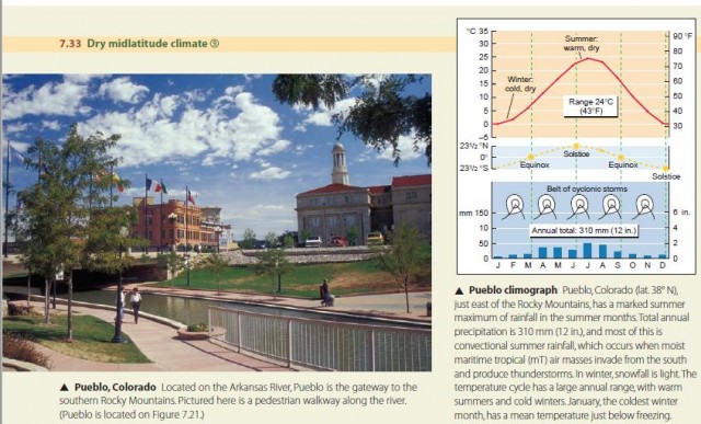
THE DRY MIDLATITUDE CLIMATE (KOPPEN: BWk, BSk)
The dry midlatitude climate is almost exclusively limited to the interior regions of North America and Eurasia, where it lies within the rain shadow of mountain ranges on the west or south. The ranges effectively block the eastward flow of maritime air masses, and continental polar (cP) air masses dominate the climate in winter. In summer, a dry continental air mass of local origin dominates, but occasionally maritime air masses invade, causing convectional rainfall. The annual temperature cycle is strongly developed, with a large annual range. Summers are warm to hot, but winters are cold to very cold.
The largest expanse of the dry midlatitude climate is in Eurasia, stretching from the southern republics of the former Soviet Union to the Gobi Desert and northern China. True arid (a) deserts and extensive areas of highlands can be found in the central portions of this region. In North America, the dry western interior regions, including the Great Basin, Columbia Plateau, and the Great Plains, are of the semiarid (s) subtype. A small area of dry midlatitude climate is found in southern Patagonia, near the tip of South America. The latitude range of this climate is 35° to 55° N. Figure 7.33 shows a climograph for Pueblo, Colorado. The low precipitation and cold winters of this semiarid climate produce a steppe landscape dominated by hardy perennial short grasses. A typical crop of this climate type is wheat.
THE MOIST CONTINENTAL CLIMATE (KOPPEN: Dfa, Dfb, Dwa, Dwb)
The moist continental climate is located in central and eastern parts of North America and Eurasia in the midlatitudes. It lies in the polar-front zone—the battleground of polar and tropical air masses. Seasonal temperature contrasts are strong, and day-to-day weather is highly variable. There is ample precipitation throughout the year, which increases in summer when maritime tropical (mT) air masses invade. Cold winters are dominated by continental polar (cP) and continental arctic (cA) air masses from subarctic source regions.
Figure 7.35 shows the global locations of the moist continental climate. It is restricted to the northern hemisphere, between lat. 30° and 55° N in North America and Asia, and in lat. 45° to 60° N in Europe. Madison, Wisconsin, in the American Midwest, provides an example. Also included is most of the eastern half of the United States from Tennessee to the north, as well as the southernmost strip of eastern Canada.
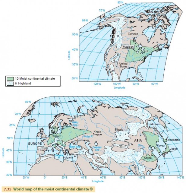
The moist continental climate of China, Korea, and Japan has more summer rainfall and a drier winter than in North America. This is an effect of the monsoon circulation, which moves moist maritime tropical (mT) air across the eastern side of Asia in summer and dry continental polar southward through the region in winter. In Europe, the moist continental climate lies in a higher latitude belt (45° to 60° N) and receives precipitation from mP air masses coming from the North Atlantic. Most of central and eastern Europe has this climate type.
Forests are the dominant natural vegetation cover throughout most of the climate. But tall, dense grasses are the natural cover where the climate grades into drier climates, such as the dry midlatitude climate.