New York City
“THE BIG APPLE,” covering 303 square mi (785 square km), is located at the southernmost point of New York State. It is bounded to the north by Westchester County, to the east by Nassau County, and to the west by the state of NEW JERSEY, across the HUDSON RIVER. The city is comprised of five counties, known as boroughs: Manhattan (New York County), Brooklyn (Kings County), Queens (Queens County), Staten Island (Richmond County), and the Bronx (Bronx County). Each county has a diverse geography and history. All boroughs except for the Bronx are either islands unto themselves (Manhattan and Staten Island) or part of islands (Brooklyn and Queens). Manhattan is 13.4 mi (21.6 km) long and 2.3 mi (3.7 km) wide at its widest point and is located between the East River on the east side and the Hudson River on the west side. The northern reaches of Manhattan are separated from the Bronx by the Harlem River. In total, New York City has 578 mi (930 km) of waterfront.
Most of Manhattan island is near sea level and relatively flat. Uneven terrain used to mark much of the island, but as development continued, the land was flattened. The northernmost tip of the island is hilly and contains Fort Tryon Park and Inwood Hill Park. The bedrock of Manhattan makes it excellent for the deep foundations needed to construct major skyscrapers. This bedrock is closest to the surface in midtown Manhattan and again in downtown Manhattan, explaining the lack of very high skyscrapers between 14th Street and the Wall Street area.
New York City was the site of the terminal moraine during the last Ice Age; the southernmost point to which the glaciers advanced. New York City owes many of its geological features to these advancing and receding glaciers. Though it is the most populous city in the United States, New York has an impressive amount of parkland. The 840-acre (340-hectare) Central Park was created in the mid-19th century in the middle of Manhattan by the architects Fredrick Law Olmsted and Calvert Vaux. Completion of the entirely man-made park involved the planting of 5 million trees and the creation of numerous lakes and ponds. Other major parks include Prospect Park in Brooklyn, and Forest Park in Queens. An intricate aqueduct system brings potable water to the city from reservoirs in the Catskill Mountains.
The original area of Manhattan Island was smaller, but over the course of the years demand for prime real estate caused landfill to be added to create a wider lower Manhattan. Water Street, on the east side of the island, was originally right on the water but is now two blocks inland. Battery Park City, on the west side of the island, is also on landfill. A 70-acre (28-hectare) freshwater body called the Collect Pond was filled by the early 18th century. The northernmost part of central Queens was also landfilled to create Flushing Meadows Park, site of the 1939–40 and 1964–65 World's fairs. Wildlife is sparse in the city, but the manmade Jamaica Bay Wildlife Refuge in southern Queens harbors many species of birds. The least populated borough, Staten Island, is also the hardest to reach. It is accessible from Manhattan by ferry or from Brooklyn by the Verrazano-Narrows Bridge. One of the largest airports in the country, Kennedy International Airport, is located in southern Queens.
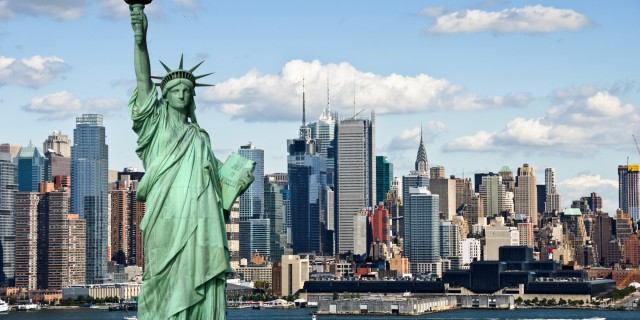
Manhattan is a destination for many tourists from around the country and around the world. Attractions include the Empire State Building, the Theater District (Times Square), historic South Street Seaport, Macy's Herald Square (the world's largest department store), the Statue of Liberty, and numerous museums including the Metropolitan Museum of Art. One of the nation's most prestigious universities, Columbia, is located in northern Manhattan; dozens of other colleges and universities are located throughout the city, including New York University and the exclusive Cooper Union, an engineering school.
Manhattan and the outer boroughs are connected by several bridges and tunnels. Manhattan and New Jersey are connected by the Lincoln Tunnel and the George Washington Bridge. Numerous rapid transit lines (including subways and commuter railroads) also cross under the East and Hudson rivers, transporting commuters to and from the suburbs as far away as southern New Jersey and Connecticut.
Manhattan's rich heritage is evident in its many different neighborhoods with distinct geographies and traditions. Some of the best known and most colorful include Greenwich Village, TriBeCa (triangle below Canal Street), SoHo (South of Houston Street), Chelsea, Hell's Kitchen, Little Italy, and Chinatown. Different neighborhoods have been trendy over the years. For example, Greenwich Village has nurtured numerous artists and writers during the 1950s and 1960s. In the outer boroughs, present-day neighborhoods such as Flushing and Jamaica were actually separate towns until consolidation with Manhattan.
Most of Manhattan's streets were designed in a numbered north-south grid pattern, called the Randall Grid, that was first developed in the early 19th century. South of 14th Street, the street layout is more irregular. In the Wall Street area at the southern tip of the island, the streets are exceptionally narrow and winding.
In 1524, the Italian explorer Giovanni da Verrazzano, sailing from Europe, discovered New York harbor. The explorer Henry Hudson sailed up what is now the river that bears his name in 1609. An explorer named Adrien Block spent about six months on the site of the future city when his ship caught fire and was destroyed, but the first permanent settlers did not arrive from Holland until 1625. By 1628, there were about 270 people living in the settlement, then known as New Amsterdam. The four other boroughs were also settled during the 1600s, by Dutch and English colonists.
Violence broke out between Manhattan settlers and the local Native Americans in 1643. In 1653, the Dutch built a protective wall across the island at the site of what is now Wall Street. Other surviving street names are indicative of the Dutch era; Beaver Street is named after the animal that fur traders sought in the 17th century, and Beekman Street is named after an early Dutch mayor of the city. In 1664, several English warships sailed into New York harbor and peacefully took over the city. The city was briefly restored to Dutch rule from 1673 to 1674.
By 1700, the prosperous city still looked very Dutch, with numerous step-gabled buildings. Settlement of the city had begun at the southern tip of Manhattan Island and proceeded north. With each passing year, the city limits crept further and further north and farmland was turned into homes. By 1760, the population had reached 18,000. The English occupied the city during the American Revolution. After the war, New York City briefly served as the capital of the nation and the first president, George Washington was inaugurated there.
A great fire in December 1835 destroyed 700 houses and with them the last of the original Dutch buildings. Thanks to Irish and German immigration, the population grew rapidly during the 19th century, from 300,000 people in 1840 to 800,000 people in 1860. During the Civil War, the city's poor revolted against the military draft. Several hundred people were killed in the ensuing riots in 1863.
Ellis Island opened in 1892 to handle the increasingly large volume of immigrants; in 1907 immigration reached its peak of more than 1.2 million people. The outer boroughs were consolidated with Manhattan in 1898 to create Greater New York. The construction of the Brooklyn Bridge in 1883 and the first subways in 1904 made transportation among the boroughs much faster. The population of the city doubled between 1900 and 1930, reaching more than 7,000,000. The completion of the Chrysler Building and Empire State Building in the 1930s and the World Trade Center in the 1970s helped create the most impressive skyline in the United States. The terrorist attacks of September 2001 leveled the Twin Towers and killed more than 2,700 people. Planners soon designed an equally imposing Freedom Tower to stand in its place.