Precipitation
The end result of most weather systems seems to be precipitation of one form or another. This is the word for falling rain, snow, hail, sleet, rime, dew and anything else that finds its way from the air to the land and consists largely of water. It appears to be untrue that the Inuit have dozens of wrords for different sorts of snow. But it is certainly true that people all over the world have a strong interest in the stuff the clouds throw at them and have vivid terms to describe it.
Of these myriad forms of water, rain is the dominant partner. Every part of the world apart from the extreme polar regions gets some from time to time and, as we have seen, some have rain more days than not. The wettest places are simply those whose location condemns them to the most rain. The most reliable rain is that whose cause is orographic.
This means that it comes about by air being pushed upwards by local topography. As we have seen, places where ocean winds meet mountainous coasts are especially prone to predictable, heavy rain. The mountain pushes the air up and as it rises, it cools down. At some point, the air will get to the point where it has more water vapour in it than it can handle. This is the “dew point”. When it is reached, water vapour turns into clouds.
More common and widespread is cloud formation caused by atmospheric convection. Here the Sun heating the ground is the original mechanism. The ground heats the air above it, and the air starts to rise until, once again, it gets to the dew point.
However, it is perfectly possible to have clouds with no rain. These tend to be cumulus clouds, calm zones of comparatively stable air that pose little risk of rain. The rain hazard comes from larger clouds called cumulonimbus, in which convection is more active. In such a cloud, water droplets convert upwards until they become too massive for the air current below', at which point they begin to fall to the ground. Their accumulation is helped by electrical static. As the water drops rub against each other, they accumulate static charges that encourage larger drops to form. The rule here is very simple – the bigger and deeper the cloud, the heavier the rain it will produce. If you think that a big, active skyful of clouds looks especially menacing, you are probably right, not just in the grip of the pathetic fallacy.
Snow may be rains chillier cousin, but it is also one of the weathers genuine wonders. It forms when clouds themselves are wrell below freezing point. If the cloud is reasonably stable, it can contain water droplets that do not freeze and are referred to as being supercooled. Ice crystals can start to form at the centre of such a droplet, especially if there is a solid nucleus (perhaps a bit of Earth dust from below, or meteor dust from above) for them to form on.
A tiny ice crystal will grow by freezing the droplet of water in which it has formed and any others it meets until it becomes heavy enough to fall. While snow'flakes are always symmetrical, they form a weird and wonderful ecology of shapes as seen under the microscope.
This mechanism explains the formation of snow, but it is also the key to a great deal of rainfall, especially outside the tropics. In temperate and polar climes, even the stuff that arrives as liquid water at ground level has often left the clouds as snow and melted on the way down. And even if it has not started out as snow, rain is usually derived from clouds that are far cooler than the ground it is falling on, and is also cooler than the air at ground level. That is why the temperature falls as rain sets in. Sometimes it is possible for supercooled water droplets to arrive as rainfall at the Earths surface. This can form the sleek ice layers which feature in traffic hazard reports in winter.
There are some variants on these basic forms in which water arrives back on Earth. One is hail, which is responsible for severe damage to crops, buildings and aircraft in flight. To get it, you need clouds that retain ice droplets by repeated convection for long periods while they build up in size. The record stone (Aurora, Nebraska, in 2003) weighed about 2kg and was over 17cm across.
The process of generating precipitation is so finely balanced that, on occasion, nothing actually gets precipitated. Virga is rain that falls from a cloud but does not reach the ground because of the updraft below. Snow that does the same is called a fallstrcak. Even water that falls from the sky does not have to be rain. If it is less than 0.5mm across, the term is drizzle, or snow pellets if frozen. Sleet is rain that has frozen in mid-flight.
It is even possible to have precipitation that does not fall from the sky. Most familiar is tog, water droplets formed near the ground surface as the temperature falls, typically around some sort of nucleus. The thick fogs that blanketed Sherlock Holmes' London are a case in point. Their virulence had much to do with the fact that almost every home in London at the time had a coal fire, whose smoke contained huge numbers of particles around which small water droplets could accumulate. The UK Clean Air Act of 1956 stopped the city's smog (smoke and fog) after a particularly bad one killed 4000 people in 1952.
More benign is dew, which forms when there is too much water vapour in the air for the prevalent temperature. When this happens – often at night – water precipitates out on some cold surface. Dew plays an important ecological role as drinking water in some parts of the world with little rain. If conditions are even chillier, it forms as ice rather than liquid wrater and is called frost or (if it is porous in structure) rime.
Weather fronts
When the forecast talks about rain, the word is usually accompanied by the word “front”. Like the paperclip, we owe the concept of weather fronts to Norway, where they were thought up by Vilhelm Bjerknes. His early-twentieth-century Bergen School of Meteorology founded the science in its modern form.
Bjerknes's insight was that the atmosphere can be regarded as a mass of blocks of air. Within a block, the basic conditions are comparatively constant, especially the temperature and the humidity, the amount of water the air contains. But when blocks meet – at a front – the differences between them allow all sorts of mayhem to break loose.
Fronts come in several types, but the main players are cold, warm, stationary and occluded. The difference between a cold and a warm front is essentially to do with who is on the winning side, and what happens to the people below.
A cold front sounds the most menacing. When one appears, cold air arrives en masse in a region previously occupied by warm air. Because cold air is denser, it pushes the warm air upwards. So for us at ground level, the day suddenly feels colder. More importantly, the warm air cools as it rises. In addition, air is a fluid, not a solid, so cold air from the incoming cold front is bound to mix with the warm air it is displacing. By now you know' what's coming. The warm air cools, forms big clouds, and, more likely than not, rain or even snow falls soon after. If you have not heard the weather forecast, you can still amaze your friends by recognizing a cold front coming in as you spot the first high clouds forming in a line. Because the warm and cold air have such vigorously differing temperatures, their impact can be turbulent, with thunderstorms forming – more on that below.
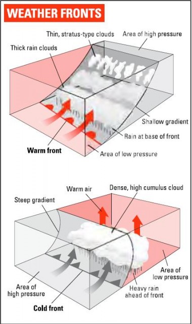
A warm front is slightly preferable. You are still going to need the umbrella, but you may be able to leave the overcoat at home. The warm air is less dense and is going to ride up over the cooler air w'hose space it is invading. As it rises, it cools, clouds form and, again, the rain follows.
In temperate climates, as we have seen, most weather runs from west to east, and the weather maps of Australia and New Zealand, or Japan, Europe and North America, typically show' the fronts hurtling from left to right. However, a warm front is more likely to be delivered by a south-westerly wind – and a cold front by a north-westerly one – in the northern hemisphere, and vice versa south of the Equator. This makes sense, since air from the direction of the tropics is likely to be warm while air arriving from more polar regions is going to be colder.
Warm and cold fronts are both wind-powered and mobile. If you live in Britain, a part of the world with lively weather and brisk winds, they are a common sight on the weather chart. More unusual is a stationary front, which is the result of warm and cold air meeting one another and remaining still, sometimes for days at a time. They are more common in regions with calmer wind regimes. When one sets in, clouds and rain can be generated in a single area for days at a time, so look out for rain checks at sports events and floods in vulnerable areas.
The final front we need to meet is the occluded front, a cousin to the stationary front. It sounds like something you might have treated at the dentist and is almost as unpleasant. Think of it as an extreme case of a cold front. In winter, you can get a warm front squeezed between cold air from both sides until it is isolated in mid-air, with cold air above and below it. The result is a region of intense turbulence and therefore of stormy weather.
These fronts are the first thing you need to look out for on weather maps and forecasts. The symbols that depict them are unvarying around the world and are shown in the diagram.
The symbology was designed in the era before colour printing was the norm, but they have survived its arrival with aplomb. A line of triangles indicates a cold front, and in colour they are blue, to suggest chilly conditions. The triangles point from cold to warm. A warm front is shown by a line of semicircles, and in colour they are shown in a warm red, this time pointing from warm air to the colder air it is likely to displace. An occluded front has them both, pointing the same way, while a stationary front has them pointing in opposite directions so you can tell which side is warm and which cold.
On weather maps in the newspaper or on TV, fronts are sometimes marked, but the basic information depicted is more likely to be limited to temperature and pressure. Wherever you live, you will soon recognize the basic shape of the weather map. In Britain, it would be a surprise not to see the hottest temperatures in the west. Even if the fronts are not marked, you can bet there is one – and work out whether it is warm or cold – by looking out for steep temperature changes, especially if they are heading in from the west or south-west. Both warm and cold fronts also need wind to push them, and therefore pressure differences, and these too are often shown on the weather map. Again, gradual pressure changes mean agreeable, balmy breezes, while steep ones mean storms.