Probing the inner depths
We may not be able to see it first hand, but we have not let that stop us finding out about the deep Earth. There is one tool above all that helps us to do so: the earthquake. As we saw in Chapter 3, the shock waves emitted by earthquakes have been used to detect the Mohorovicic Discontinuity at the base of the crust. But they can tell us much more than this, and allow us to see all the way to the Earths centre.
Earthquake shock waves come in two forms. P waves are “compression” waves in which the matter making up the Earth is compressed and then pulled apart by the passing wave, in the direction of its travel. With S waves, or shear waves, the material moves from side to side at right angles to the direction of the wave. Sound in air is a P wave. Watch the sea and you are viewing S waves.
A sizeable earthquake will produce waves of both types detectable across most of the Earth. They are measured and timed by a network of seismometers across the planet, mostly in universities and government laboratories, which have now accumulated many decades of data.
S waves move more slowly than P waves. More intriguingly, they cannot travel in fluids. As we shall see, the Earths core is liquid, consisting mainly of molten iron. Its existence was discovered back in 1906 because for any earthquake, there is a zone on the Earths surface at which the resulting S waves cannot be detected. This happens because these waves would need to pass through the core to get there. Called the Shadow Zone, this area starts 105° from the epicentre of the earthquake. It took seismology a little longer to prove the existence of the inner core. But by 1936 more detailed analysis of the time it took P waves to travel through the core had shown that there was an area at its centre through which waves were travelling faster than they would through a liquid. This showed that the core must have a solid centre.
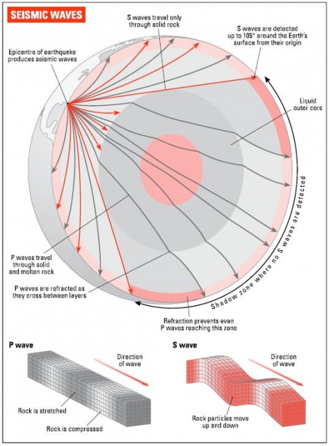
Seismometers can detect a rich range of earthquake-wave effects. As we saw in Chapter 3, waves can be reflected off the Moho, or can be refracted along it. The same is true for the boundary between the mantle and the core. For any earthquake, detailed maps of the routes taken by seismic waves can be drawn up. Over time, this information has allowed the depths of major structures within the Earth to be mapped in detail. In more recent times especially, it has also become possible to use earthquake traces to map smaller details of the inner Earth. These include molten rock bodies associated with volcanoes, and deep areas of high and low seismic velocity which convey information about Earth history.