Slope Erosion
Most of the world's land surface has been sculpted by running water. Waves, glacial ice, and wind also carve out landforms, but for physical geographers, running water is the most important. That's because landforms made by glacial ice, wind, and waves are restricted to certain areas on the globe. We'll look at some of these other landformcreating agents in later chapters, but in this chapter we will concentrate on fluvial landforms.
Fluvial landforms are made by fluvial processes, which include overland flow and streamflow. Flowing as a sheet across the land, running water picks up particles and moves them downslope. When rainfall is heavy, streams and rivers swell, lifting large volumes of sediment and carrying them downstream. Weathering and the slower forms of mass wasting, such as soil creep, operate hand in hand with overland flow, supplying the rock and mineral fragments that are carried into stream systems. In this way, running water erodes mountains and hills, carves valleys, and deposits sediment.
There are two major groups of landforms—erosional landforms and depositional landforms. As a crustal block is uplifted by plate tectonic activity, it is attacked by running water. Valleys form as rock is eroded away by fluvial agents. The ridges, hills, or mountain summits that we see between valleys are the surviving parts of the crustal block that have not yet been carved by running water. The landforms shaped by the progressive removal of bedrock are erosional landforms. Fragments of soil, regolith, and bedrock removed from the parent rock mass are transported and deposited elsewhere, making an entirely different set of surface features—the depositional landforms.
Fluvial action starts on the uplands as soil erosion. Overland flow picks up particles of mineral matter ranging in size from fine colloidal clay to coarse sand or even gravel. The size of particles removed depends on how fast the flow moves and how tightly plant rootlets and leaves hold down the soil. The water also carries dissolved mineral ions.
This process happens everywhere precipitation falls. Under stable natural conditions in a humid climate, the erosion rate is slow enough to allow soil to develop normally. Each year a small amount of soil is washed away, while a small amount of solid rock material is turned into regolith and soil. This stable equilibrium is called the geologic norm.
ACCELERATED SOIL EROSION
In contrast to this natural balance, human activities can produce accelerated erosion. Destroying vegetation and clearing land for cultivation sets the stage for a series of drastic changes. With no foliage to intercept rain and no ground cover from fallen leaves and stems, raindrops fall directly on the mineral soil. In these cases, soil is removed much faster than it can be formed, exposing the uppermost soil horizons. Some natural events, such as forest fires, can also speed up soil erosion.
When falling raindrops hit bare soil, their force causes a geyser-like splashing in which soil particles are lifted and then dropped into new positions. This is called splash erosion. A torrential rainstorm can disturb as much as 225 metric tons of soil per hectare (about 100 U.S. tons per acre). On a sloping ground surface, splash erosion shifts the soil slowly downhill. The soil surface also becomes much less able to absorb water. This important effect occurs because the natural soil openings become sealed by particles shifted by raindrop splash. Since water cannot infiltrate the soil as easily, a much greater depth of overland flow can be triggered from a smaller amount of rain. This intensifies the rate of soil erosion.
Destroying vegetation also reduces the resistance of the ground surface to erosion by overland flow. On a slope covered by grass sod, even a deep layer of overland flow causes little soil erosion. This is because the grass stems are tough and elastic, creating friction with the moving water and taking up the water's energy to erode. Without a cover, the water can easily dislodge soil grains, sweeping them downslope.
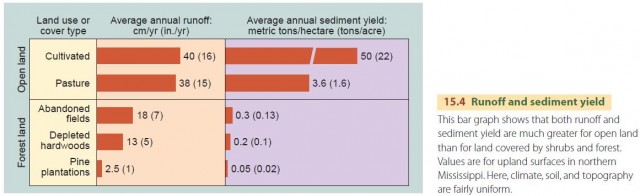
How does erosion from vegetated land compare with erosion from open land? To compare erosion rates, we use sediment yield—a technical term for the rate of sediment removal in metric tons per hectare per year (tons per acre per year). As shown in Figure 15.4, both surface runoff and sediment yield are much lower for vegetated surfaces. In fact, sediment yield from cultivated land undergoing accelerated erosion is over 10 times greater than that of pasture and about a thousand times greater than that of a pine plantation.
Accelerated soil erosion is a big problem in cultivated regions with a substantial water surplus. We don't see much erosion immediately after forest or prairie grasslands are removed and the soil is plowed for cultivation. But once rain splash erosion has broken down soil aggregates and sealed the larger openings, making it harder for water to infiltrate, overland flow removes the soil in thin, uniform layers. This process is called sheet erosion. Because of seasonal cultivation, the effects of sheet erosion are often little noticed until the upper layers of the soil are removed or greatly thinned.
Where land slopes are steep, runoff from torrential rains is even more destructive. Rill erosion scores many closely spaced channels into the soil and regolith. If these rills are not destroyed by soil tillage, they can join together to make still larger channels. These deepen rapidly, turning into gullies—steep-walled, canyon-like trenches whose upper ends grow progressively upslope. Ultimately, accelerated soil erosion creates a rugged, barren topography.
Soil particles picked up by overland flow are carried downslope. Eventually, they reach the base of the slope, stopping where the surface slope becomes more gentle and meets the valley bottom. As we saw in Chapter 13, these particles accumulate in a thickening layer known as colluvium. Because this deposit is built by overland flow, it is distributed in sheets, making it difficult to notice unless it eventually buries fence posts or tree trunks.
Any sediment that isn't deposited as colluvium is carried by overland flow until it reaches a stream. Once in the stream, it is carried farther downvalley where it can build up as alluvium in layers on the valley floor. Alluvium can bury fertile floodplain soil under infertile, sandy layers. Coarse alluvium chokes the channels of small streams, making the water flood over the valley bottoms.
SLOPE EROSION IN SEMIARID AND ARID ENVIRONMENTS
So far, we've been talking about slope erosion in moist climates where there are natural forests or dense prairie grasslands. Conditions are quite different in a midlatitude semiarid climate with summer drought. Here, the natural plant cover is short-grass prairie (steppe). It is sparse and provides a rather poor ground cover of plant litter, but the grass cover is normally strong enough to slow the pace of erosion.
We also see these conditions in the tropical savanna grasslands. But in these semiarid environments, the natural equilibrium is highly sensitive and can easily be upset. Fires or grazing herds of domesticated animals that reduce the plant cover can easily trigger rapid erosion. These sensitive, marginal environments don't rapidly recover from accelerated erosion once it begins.
Erosion at a very high rate by overland flow is actually a natural process in certain locations in semiarid and arid lands. Here, the erosion produces badlands. Badlands are underlain by clay formations, which are easily eroded by overland flow. Erosion rates are too fast to permit plants to take hold, and no soil can develop. A maze of small stream channels is developed, and ground slopes are very steep.