Southeast Asia, Oceania, and Antarctica: Landforms and Resources
A HUMAN PERSPECTIVE The Aeta people of the Philippines lived on the volcano Mount Pinatubo for generations. They knew this volcano so well that they timed the planting and harvesting of their crops by the amount of steam rising from a vent on its slope. In 1991, the Aeta noticed changes in the mountain and concluded that it was about to erupt. Tens of thousands of Aeta fled their homes as did countless other Filipinos. Pinatubo did erupt for the first time in 600 years, spewing ash for miles. Since then, many of the Aeta have formed new communities, but they still miss their homeland. As their story shows, the geologic processes that destroy landforms also disrupt human lives.
Southeast Asia: Mainland and Islands
Southeast Asia has two distinct subregions: the southeastern corner of the Asian mainland and a great number of islands. Both the mainland and the islands have many high mountains.
PENINSULAS AND ISLANDS
The most noticeable feature of mainland Southeast Asia is that it lies on two peninsulas. The Indochinese Peninsula, located south of China, has a rectangular shape. In contrast, the Malay Peninsula is a narrow strip of land about 700 miles long, stretching south from the mainland and then curving southeast. It serves as a bridge between the mainland and islands.
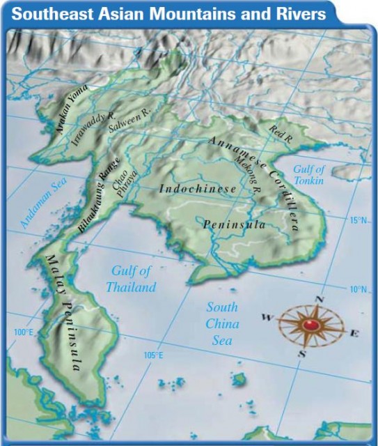
Most of the islands of Southeast Asia are found in archipelagoes. An archipelago is a set of closely grouped islands, which sometimes form a curved arc. The Philippines and the islands of Indonesia are part of the Malay Archipelago. A few Southeast Asian islands, such as Borneo, are actually the high points of a submerged section of the Eurasian plate.
MOUNTAINS AND VOLCANOES
On the map at right, you can see that the mainland has several mountain ranges, such as the Annamese Cordillera, running roughly north and south. These ranges fan out from a mountainous area to the north.
On the islands, most of the mountains are of volcanic origin. Southeast Asia is part of the Pacific Ring of Fire that you read about in Chapter 29. Volcanic eruptions and earthquakes are natural disasters that frequently occur in this region.
RIVERS AND COASTLINES
The mainland has several large rivers that run from the north through the valleys between the mountain ranges. Near the coast these rivers spread out into fertile deltas. For example, the Mekong River begins in China and crosses several Southeast Asian nations before becoming a wide delta on Vietnam's coast. Millions of people rely on the Mekong for farming and fishing.
Southeast Asia's peninsulas and islands give it a long, irregular coastline with many ports. As you can imagine, this has encouraged a great deal of seagoing travel and trade.
RESOURCES
Fertile soil is a valuable resource in Southeast Asia. Volcanic activity and flooding rivers both add nutrients back to the soil and keep it rich. Southeast Asians also have access to large numbers of fish in the rivers and nearby seas. Parts of the region have mineral resources, such as petroleum, tin, and gems, which industry can use.
Lands of the Pacific and Antarctica
No one knows how many islands exist in the Pacific Ocean, but some geographers estimate that there are more than 20,000. As a group, the Pacific Islands are called Oceania. (The Philippines, Indonesia, and other islands near the mainland are not considered part of Oceania because their people have cultural ties to Asia.) In the southwestern Pacific lie New Zealand and Australia, which are often considered part of Oceania, even though Australia is a continent, not an island.
OCEANIA'S MANY ISLANDS
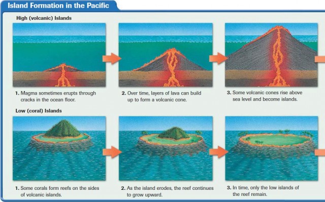
One reason geographers don't know the number of islands in Oceania is that it changes. Erosion causes some islands to vanish, while other forces create new islands. Most Pacific islands fall into two categories: high islands are created by volcanoes, and low islands are made of coral reefs. Although a few of Oceania's islands are large, most are small. If you added the land area of all the islands together, the total would be smaller than the area of Alaska.
Oceania is not rich in resources. The low islands have poor soil, and most of the islands lack minerals. But New Caledonia has nickel, chromium, and iron; New Guinea has copper, gold, and oil; Nauru has phosphate; and both Fiji and the Solomon Islands have gold. The general scarcity of resources has made it difficult to develop industry.
MAJESTIC NEW ZEALAND
New Zealand has two main islands, North Island and South Island. Running down the center of South Island is a 300-mile-long mountain range, the Southern Alps. This range has 16 peaks over 10,000 feet high and more than 360 glaciers. Several rivers flow down the eastern slopes to the ocean.
North Island has hilly ranges and a volcanic plateau, but it is much less mountainous than South Island. North Island has fertile farmland and forest that support the lumber industry. In addition, its coastline has natural harbors that are used for seaports. Like South Island, North Island has many rivers running from the mountains to the sea.
New Zealand has few mineral resources. However, its swift-flowing rivers have allowed its people to build dams that generate electricity. Also, North Island has a volcanic area with underground steam.
Engineers have found ways to use this steam to power generators.
FLAT AUSTRALIA
The land mass known as Australia is the smallest continent on earth. It is also the flattest. Near the eastern coast, running roughly parallel to it, is a chain of highlands called the Great Dividing Range. Unlike New Zealand's mountains, few of these peaks rise higher than 5,000 feet. To the west of this range stretches a vast expanse of plains and plateaus, broken by only a few mountains.
Many other differences exist between Australia and New Zealand. For example, Australia has very few rivers. The largest is the Murray River, which flows into the Southern Ocean. Forestry is not a major industry in Australia, but the country is rich in minerals. It is the world's leading supplier of bauxite, diamonds, opals, lead, and coal.
Along Australia's northeast coast lies one of the wonders of nature. The Great Barrier Reef is often called the world's largest coral reef, although it is really a 1,250-mile chain of more than 2,500 reefs and islands. Some 400 species of coral are found there.
ICY ANTARCTICA
Antarctica is the fifth largest continent. Generally circular in shape, it is centered on the South Pole. Its topography is hidden by a thick ice sheet, but under the ice lies a varied landscape. The Transantarctic Mountains divide the continent in two. East Antarctica is a plateau surrounded by mountains and valleys. West Antarctica is a group of separate islands linked only by the ice that covers them.
Antarctica's ice sheet is the largest supply of fresh water in the world. Geologists believe that resources such as coal, minerals, and perhaps even petroleum may lie beneath the ice. But in 1991, 26 nations agreed not to mine Antarctica for 50 years. In the next section, you will read about Antarctica's harsh climate as well as the climates of Southeast Asia, Oceania, Australia, and New Zealand.