Subregions of Canada
A HUMAN PERSPECTIVE The Grand Banks, a shallow section of the North Atlantic off the coast of Newfoundland, make up one of the earth's richest fishing grounds. In fact, it was the abundance of fish—including cod, haddock, herring, and mackerel—that first attracted Europeans to the region centuries ago. Today, thousands of hardy Canadians make their living fishing in these coastal waters. One, Alex Saunders of Labrador, remarked that “fishing is a disease. Once you start, you keep at it, do whatever's necessary. I jeopardize my home, all my possessions just to keep this boat going and keep fishing.” The Grand Banks are part of the Atlantic Provinces, one of Canada's four subregions.
The Atlantic Provinces
Canada is divided into ten provinces and three territories. Each has a unique population, economy, and resources. Eastern Canada is the location of the four Atlantic Provinces—Prince Edward Island, New Brunswick, Nova Scotia, and Newfoundland.
HARSH LANDS AND SMALL POPULATIONS
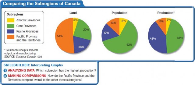
As you can see on the chart below, the Atlantic Provinces are home to just 8 percent of Canada's population. Of these people, most live in coastal cities, such as Halifax, Nova Scotia, and St. John, New Brunswick. The small population is due largely to the provinces' rugged terrain and severe weather. For example, about 85 percent of the land in Nova Scotia cannot be farmed because of rocky hills and poor soil. In New Brunswick, forests cover 90 percent of the land. Newfoundland—made up of the island of Newfoundland, Labrador, and nearby islands—is visited by fierce storms that roar up the Atlantic seaboard.
ECONOMIC ACTIVITIES
Despite the sometimes harsh conditions, the people of the Atlantic Provinces have learned to use what the land and the sea offer them. For example, New Brunswick's dense forests provide the province with its largest industry—logging. This industry produces lumber, wood pulp, and paper products. The Gulf of St. Lawrence and coastal waters supply plentiful stocks of seafood for export. Also, there is mining for zinc, copper, lead, and silver.
Logging and fishing are mainstays of the economy of Nova Scotia, too. This province boasts one of the largest fish-processing plants in North America. In addition, shipbuilding and trade through the port of Halifax provide more employment and revenue. Until the 20th century, fishing was the principal industry in Newfoundland. Today, the province also has healthy mining and logging industries. Moreover, its hydroelectric-power resources are part of a system supplying power to Quebec and parts of the northeastern United States.
The Core Provinces— Quebec and Ontario
In 1608, Samuel de Champlain, a French explorer, built a fort, the first European structure in what is now Canada, at present-day Quebec City. Four centuries later, the lands he colonized are part of the country's most dynamic region—Quebec and Ontario, Canada's Core Provinces.
THE HEARTLAND OF CANADA
Quebec and Ontario are often referred to as Canada's heartland, and with good reason. Three out of five Canadians live there. Ontario is the largest province in terms of population, Quebec in land area. Most of the settlement in these inland provinces is found along the Great Lakes and the St. Lawrence River. Each province is the core of one of Canada's two major cultures. A large number of Canada's English-speaking majority live in Ontario. For most French-speaking Canadians, Quebec is home.
CANADA'S POLITICAL AND ECONOMIC CENTER
Ontario and Quebec are at the center of Canada's political and economic life. Ottawa is the capital of the federal government. It is located in southeastern Ontario, right next to the border of Quebec province. Quebec has its own political importance as the heart of French Canadian life.
Ontario and Quebec also power Canada's economy. Together, they account for more than 35 percent of Canadian agricultural production, 45 percent of its mineral output, and 70 percent of its manufacturing. As the map on page 160 shows, they supply a wide variety of products.
Toronto, located on the shores of Lake Ontario, is not only the country's most populous city but also its banking and financial hub. Montreal, located on the St. Lawrence River, is Canada's second largest city. It is the center of economic and political activity in Quebec province.
The Prairie Provinces
To the west of the hustle and bustle of Ontario and Quebec lie the Prairie Provinces—Manitoba, Saskatchewan, and Alberta.
CANADA'S BREADBASKET
Canada's Prairie Provinces are part of the Great Plains of North America. These three provinces are the center of the nation's agricultural yield. They account for 50 percent of Canada's agricultural production. The land of the Prairie Provinces, however, consists of more than just fertile soil. About 60 percent of Canada's mineral output comes from this region of the country. Alberta itself has the nation's largest known deposits of coal and oil and produces 90 percent of Canada's natural gas.
A CULTURAL MIX
The people of the Prairie Provinces are a diverse group. Manitoba has large numbers of Scots-Irish, Germans, Scandinavians, Ukrainians, and Poles. The town of St. Boniface boasts the largest French-Canadian population outside Quebec. The population of Saskatchewan also includes immigrants from South and East Asia and is home to the metis. Alberta is perhaps the most diverse of all. In addition to European immigrants, this province also has significant Indian, Japanese, Lebanese, and Vietnamese populations.
The Pacific Province and the Territories
The province of British Columbia along with the three territories—Yukon Territory, Northwest Territories, and Nunavut—make up Canada's western and northern lands.
BRITISH COLUMBIA
Canada's westernmost province is British Columbia. Nearly all of it lies within the Rocky Mountain range. As a result, three-fourths of the province is 3,000 feet or more above sea level. More than half of the land is densely forested, and nearly one-third is frozen tundra, snowfields, and glaciers.
Most of the population is found in the southwest. This is the location of British Columbia's two largest cities, Victoria and Vancouver. The economy is built on logging, mining, and hydroelectric-power production. Vancouver is Canada's largest port and has a prosperous shipping trade.
THE TERRITORIES
Canada's three territories make up 41 percent of the country's land mass. Yet, they are too sparsely populated to be provinces. The Yukon Territory, with a population around 30,000, lies north of British Columbia and is largely an unspoiled wilderness. Directly east is the Northwest Territories, an area that extends into the Arctic. It has a population of about 41,000 people.
Nunavut was carved out of the eastern half of the Northwest Territories in 1999. It is home to many of Canada's Inuit. Even though the land is rugged and climatic conditions are severe, economic activities take place in the territories. Mining, fishing, and some logging are the principal industries, and these widely scattered activities explain why the settlements are so dispersed.
In this chapter and the last, you read about the human geography of the United States and Canada. In the next chapter, you will learn about some of the issues that are facing those countries today.