Subregions of the United States
A HUMAN PERSPECTIVE America's back roads were the beat of reporter and author Charles Kuralt for more than 20 years. Beginning in the 1960s, he traveled by van through every region of the country. In his “On the Road” series for television, he reported on the uniqueness of the lives of ordinary Americans. He said that he wanted to make these trips off the beaten path because most people traveled across the country on interstate highways without seeing the “real” America. Whether he visited Minnesota's lake country or a small New England town, Kuralt spotlighted America's regional diversity. In fact, one of the key strengths of the United States is the variety of life in its subregions—the Northeast, the Midwest, the South, and the West.
The Northeast
As you can see on the map, the Northeast covers only 5 percent of the nation's land area. But about 20 percent of the population lives there. The six northern states of the subregion—Maine, Vermont, New Hampshire, Massachusetts, Rhode Island, and Connecticut—are called New England. The other three—Pennsylvania, New York, and New Jersey—are sometimes referred to as Middle Atlantic states. (Maryland and Delaware, which are included in the South in this book, are sometimes included in the Middle Atlantic states.)
AMERICA'S GATEWAY
Because of its location along the Atlantic coast, the Northeast contains many of the areas first settled by Europeans. The region served as the “gateway” to America for millions of immigrants from all over the world. Many people still engage in fishing and farming, as the Northeast's early settlers did. But the region's coastal and inland waters turned it into the heart of trade, commerce, and industry for the nation. In fact, the Northeast is one of the most heavily industrialized and urbanized areas in the world. The Atlantic seaboard cities of Philadelphia, Boston, and New York City serve as international trade centers.
Coal, iron ore, and oil—found mainly in Pennsylvania—fueled the industrialization of the region. Traditional industries, such as iron and steel, petroleum, and lumber, still play a role in the region's economy. But most Northeasterners are now employed in such manufacturing and service industries as electronics, communications, chemicals, medical research, finance, and tourism. Pennsylvania, New York, and New Jersey have rich farmlands, but much of New England is too hilly or rocky to grow crops easily.
Parts of the Middle Atlantic states are often referred to as the “rust belt” because of their declining and abandoned traditional industries. They share this term with some of the states of the Midwest. In recent times, many “rust belt” industries have moved to the warmer climates of the “sunbelt” in the South and West.
GROWTH OF THE MEGALOPOLIS
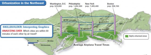
The nation's first megalopolis developed in the Northeast. A megalopolis is a region in which several large cities and surrounding areas grow together. You can see the extent of the “BosWash” megalopolis, as it is called, in the illustration on page 145. It stretches through 500 miles of highly urbanized areas from Boston in the north to Washington, D.C., the national capital, in the south. It contains one-sixth of the U.S. population. New York City, the country's cultural and financial center, is located here. Rapid road, rail, and air links have been vital to its economic development and expansion into the South. You will read more about urban growth in Chapter 8.
The Midwest
The subregion that contains the 12 states of the north-central United States is called the Midwest. Because of its central location, the Midwest is called the American heartland. It occupies about one-fifth of the nation's land and almost one-fourth of its people live there. Since the Revolutionary War, immigrants from all over the world have made it their destination. Many early settlers came from Britain, Germany, and Scandinavia. Vast, largely flat plains are a distinctive feature of the region. So are numerous waterways, including the Great Lakes and the Mississippi River and its many tributaries.
AGRICULTURAL AND INDUSTRIAL HEARTLAND
The Midwest is the nation's “breadbasket.” Fertile soil, adequate rainfall, and a favorable climate enable Midwesterners to produce more food and feed more people than farmers in any comparable area in the world. Among the main products are corn, wheat, soybeans, meat, and dairy goods. Agriculture also is the foundation for many of the region's industries, including meatpacking, food processing, farm equipment, and grain milling. Other traditional industries are steel and automaking.
Its central location and excellent waterways make the Midwest a trade, transportation, and distribution center. Chicago, Illinois, which is located near the southwestern shores of Lake Michigan, is the cultural, financial, and transportation hub of the Midwest. Most of the region's major cities developed near large bodies of water, which were essential for early transportation. Cleveland, Detroit, Chicago, and Milwaukee grew near the Great Lakes, and Cincinnati, St. Louis, Minneapolis, St. Paul, Kansas City, and Omaha developed along rivers.
CHANGING FACE OF THE MIDWEST
Like other regions, the Midwest is changing. The number of farms is declining. More Midwesterners are now employed in providing services than in traditional industries. The region's metropolitan areas are expanding as urban dwellers and businesses leave the central cities for the suburbs. People and industries are also moving to the warmer South and West.
The South
The South is a subregion that covers about one-fourth of the land area of the United States and contains more than onethird of its population. Among its 16 states are 11 that made up the Confederacy during the Civil War. One of these states—Texas—is sometimes included in an area of the West called the Southwest. The South's warm climate, fertile soils, and many natural resources have shaped its development.
THE OLD SOUTH
Like the Northeast, the South was also the site of early European settlement. In fact, Virginia was England's first American colony. The South has a mix of cultures that reflects the diversity of its early settlers. In addition to people of British heritage, there are the descendants of Africans brought as slave laborers and Hispanics whose families first migrated from Mexico to Texas. Cajuns of French-Canadian origin and Creoles of French, Spanish, and African descent are found in Louisiana, while Florida is home to many Hispanics who came from Cuba.
Once a rural agricultural area, the South is rapidly changing and its cities growing. Along with the Southwest, it is often referred to as the “sunbelt” because of its climate.
THE NEW SOUTH
Agriculture was the South's first economic activity, and cotton, tobacco, fruits, peanuts, and rice are still grown there. Also, livestock production is important in states such as Texas and Arkansas. The South's humid subtropical climate at first hindered industrialization. But the widespread use of air conditioning beginning in the 1950s and the region's vast stores of energy resources—oil, coal, natural gas, and water—gave a boost to industry.
In recent times, the South has attracted many manufacturing and service industries fleeing the harsh weather of the “rust belt.” Major industries include petroleum, steel, chemicals, food processing, textiles, and electronics. The South's climate draws millions of tourists and retirees, too. Atlanta, Georgia—a financial, trade, and transportation center—is the hub of the New South. Miami, Tampa-St. Petersburg, New Orleans, Houston, Dallas-Fort Worth, and San Antonio are other rapidly growing metropolitan areas—large cities and nearby suburbs and towns.
The West
Look on the map on page 134, and you will see that the West is a farflung subregion consisting of 13 states. It stretches from the Great Plains to the Pacific Ocean and includes Alaska to the north and Hawaii in the Pacific. The West covers about one-half of the land area of the United States but has only about one-fifth of the population. It is a region of dramatic and varied landscapes.
People settle in the West today as they did during its frontier days: wherever landforms and climate are favorable. Some areas, such as its many deserts, are sparsely settled. Nonetheless, California is the country's most populous state because of excellent farmland, good harbors, and a mild climate. The West is the most rapidly growing region in the United States. Los Angeles, the country's second largest city, is the West's cultural and commercial center.
DEVELOPING THE WEST
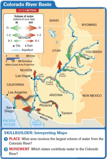
The West's growth in the 20th century was helped by air conditioning and by irrigation. The map on this page, for example, shows how water from the Colorado River in Arizona has been diverted to serve many areas. Water supply aided development of inland cities such as Las Vegas, Tucson, and Phoenix.
The economic activities of the West are as varied as its climate and landscape. Among them are farming, ranching, food processing, logging, fishing, mining, oil refining, tourism, filmmaking, and the production of computers. Many cities with good harbors, including Seattle, Los Angeles, and Long Beach, make foreign trade— especially with Asia—important. You read about the subregions of the United States in this section. In the next chapter, you will learn about the human geography of Canada.
- Economy and Culture of the United States
- History and Government of the United States
- The United States and Canada: Human–Environment Interaction
- The United States and Canada: Climate and Vegetation
- The United States and Canada: Landforms and Resources
- Puerto Rico (USA)
- Northern Mariana Islands (USA)
- Guam (USA)
- American Samoa (USA)