The Geographer’s Tools
A HUMAN PERSPECTIVE At noon on a sunny midsummer day, sometime around 255 B.C., Eratosthenes drove a stake into the ground at the mouth of the Nile River in Alexandria, Egypt. He then noted the angle of the shadow cast by the stake. Meanwhile at Syene (modern-day Aswan, Egypt), another person drove a stake into the ground—but it cast no shadow. Using the angle of the first shadow and the distance between Syene and Alexandria, Eratosthenes calculated the circumference of the earth. By today's measurements, he was off by about 15 percent, but he was remarkably accurate considering the simple tools he used. Eratosthenes was one of the earliest geographers to use tools and critical thinking to measure and describe the earth.
Maps and Globes
A geographer's tools include maps, globes, and data that can be displayed in a variety of ways. The oldest known map is a Babylonian clay tablet created about 2,500 years ago. The tablet is about four inches high and shows the Babylonian world surrounded by water. Over the centuries, mapmaking evolved into a very complex task. However, a map's function has remained the same—to show locations of places, landforms, and bodies of water, and where they are in relation to other parts of the earth.
TWO OR THREE DIMENSIONS
A globe is a three-dimensional representation of the earth. It provides a way to view the earth as it travels through space. But since the earth is a sphere, we can see only one half of it at any time. For certain tasks, globes are not very practical because they are not easily portable.
People often prefer to use maps, which are two-dimensional graphic representations of selected parts of the earth's surface. Maps are easily portable and can be drawn to any scale needed. The disadvantage of a map is that distortion occurs as the earth's surface is flattened to create the map. A cartographer, or mapmaker, reduces some types of distortion by using different types of map projections. A map projection is a way of drawing Earth's surface by presenting a round Earth on flat paper. To learn more about map projections, see the Geography Skills Handbook, pages 18–19.
TYPES OF MAPS
The three types of maps are general reference maps, thematic maps, and navigational maps. One kind of general reference map is called a topographic map, which is a representation of natural and man-made features on the earth. Thematic maps emphasize specific kinds of information, such as climate or population density. Sailors and pilots use the third type of map—navigation maps. You can learn more about using different maps in the Geography Skills Handbook, pages 20–23.
The Science of Mapmaking
A cartographer decides what type of map to create by considering how the map will be used. Keeping that purpose in mind, he or she then determines how much detail to show and what size the map should be.
SURVEYING
The first step in making a map is to complete a field survey. Surveyors observe, measure, and record what they see in a specific area. Today, most mapping is done by remote sensing, the gathering of geographic information from a distance by an instrument that is not physically in contact with the mapping site. These data are gathered primarily by aerial photography or by satellites.
The data gathered includes information such as elevation, differences in land cover, and variations in temperature. This information is recorded and converted to a gray image. Cartographers then use these data and computer software to construct maps. See the illustration below to learn more about satellite surveying.
SATELLITES
Today, geographers rely heavily on satellites to provide geographic data. Two of the best-known satellites are Landsat and GOES. Landsat is actually a series of satellites that orbit more than 100 miles above Earth. Each time a satellite makes an orbit, it picks up data in an area 115 miles wide. Landsat can scan the entire Earth in 16 days. Geostationary Operational Environment Satellite (GOES) is a weather satellite. This satellite flies in orbit in sync with Earth's rotation. By doing so, it always views the same area. It gathers images of atmospheric conditions that are useful in forecasting the weather.
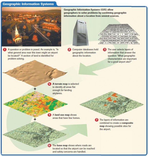
GEOGRAPHIC INFORMATION SYSTEMS
The newest tool in the geographer's toolbox is Geographic Information Systems (GIS). GIS stores information about the world in a digital database. GIS has the ability to combine information from a variety of sources and display it in ways that allow the user to visualize the use of space in different ways. When using the system, geographers must look at a problem and decide what types of geographic information would help them solve the problem. The information could include maps, aerial photographs, satellite images, or other data. Next, they select the appropriate layers of information. Then, GIS creates a composite map combining the information. Study the diagram on page 12 to learn more about the way GIS works.
GLOBAL POSITIONING SYSTEM (GPS) A familiar tool
of geographers is GPS or Global Positioning System. It was originally developed to help military forces know exactly where they were on the earth's surface. The system uses a series of 24 satellites called Navstars, which beam information to the earth. The exact position—latitude, longitude, altitude, and time—is displayed on a hand–held receiver. Hikers, explorers, sailors, and drivers use GPS devices to determine location. They are also used to track animals.
Geographers use a variety of other tools including photographs, cross sections, models, cartograms, and population pyramids. These tools help geographers to visualize and display information for analysis. They are looking for patterns and connections in the data they find. You will learn how to use these tools in the Geography Skills Handbook, which follows, and in the Map and Graph Skills pages in this book.