The weather machine
Despite this reassuringly stable structure, the atmosphere is the most restless component of the Earth. Continents creep apart at a few centimetres a year, ocean currents are measured in kilometres an hour – but the fastest wind ever measured, on 12 April 1934 on Mount Washington in New Hampshire, US, was 372kph.
But although there is plenty of wild weather in the world, the climate of the Earth is surprisingly stable. Indeed, the record of ancient wind-borne sediments dating back millions of years proves that stability has been the rule for long periods of Earth history.
One major pattern of the Earths climate that you may be aware of yourself is that most of it seems to run from west to east. This is true in the temperate regions of the Earth where, as a reader of this book, you most likely live. However, as the diagram on p. 140 show's, while westerly winds (remember that a wind gets its name from the direction it comes from, not where it is going to) dominate these regions, they are not the whole story. Elsewhere, the dominant airflow can be east-west or even north-south. This is the General Circulation of the Wind, and is yet another thing first worked out by Edmond Hailey when he was not thinking about his comet.
There are two main sources of energy for the movement of the atmosphere. One is incoming solar power. Here the story is one of change, especially on an annual basis. As we saw in Chapter 2, the subsolar point – the place on the Earth where the Sun is straight overhead – moves from the Tropic of Cancer in the northern hemisphere to the Equator, on down to the Tropic of Capricorn, and back again over twelve months. The redistribution ot heat and light over this period drives the seasons.
Quicker-acting in its effect is the rotation of the Earth itself. The sight of the Sun rising in the east can also be regarded as the Earths horizon tailing below the point in the sky where the Sun happens to be. So the Earth is spinning from west to east. At the Equator, everything moves at nearly 1700kph just to manage one lap per day. But the nearer you get to the poles, the slower your rotational velocity will be, until at the poles themselves it drops to nothing. If you launched a rocket from the North Pole straight at London, it wrould never arrive because it would have no rotational velocity. The Earths rotation would have shitted London out of the way before it got there. Viewed from the ground, the missile would appear to be subject to a force deflecting it to the west. We call this the Coriolis Force, in honour of Gustave-Gaspard Coriolis, wrho wrote the equations for how it works in 1835.
As we shall see, the principle had been known for centuries by that time. In fact, M. Coriolis seems to have got his name attached to a major scientific principle with less justification than almost anyone else on record.
The Coriolis Force means that Equator-bound objects, wrhether coming from the north or the south, are pushed towards the west, while objects heading away from the Equator are diverted east. The effect is strongest near the poles.
This is a vital consideration for anyone planning an intercontinental missile attack, or navigating an aircraft. But it also has a lot to do with how-weather systems form. When one part of the atmosphere has lowrer pressure than another, you get wind, which is simply molecules of air moving from somewhere with high pressure to a place nearby where it is lower. It wants to go in straight lines, but the Coriolis Force means it cannot. So how' do these effects turn into weather?
Spend some time in the cells
The weather is a global system and does not start in any one place, but it is simpler to pretend that it does. The best place for us to begin is at the Equator. The Sun pushes more heat onto the Earth near the Equator than it does in higher latitudes. So the air there gets hot. When air is heated, it expands and its density drops, so it starts to rise, and is pushed north or south by air following it. This rising air is wet and sheds large amounts of rain as it rises. This is why the equatorial regions are among the Earths wettest, and are home to the great jungles of Africa and South America. Here rainfall tends to be over 1500mm a year. As my sceptical, but not very culturally aware, geography teacher Mr Ball once explained, any priest who starts a rain dance in the Amazon basin will not have to wait long before claiming success.
Because the air at the Equator is constantly being pulled upwards as the Sun heats it, it needs to be replaced. This is why the equatorial region is described as a “convergence”. At the Equator, ships in the days of sail could be stuck for weeks in the “doldrums'; a zone with little wind because the only way out for the air is straight up. But immediately to its north or south, the Trade Winds blow reliably – from the north-east above the Equator and the south-east belowr it. These winds got their name because they were supremely useful for anyone planning serious maritime commerce.
The Trade Winds are the sea-level sign of the equatorial Hadley cells of air circulation, identified by the English scientist George Hadley in 1735. The air that rose at the Equator is pushed north and south, and once it starts on its journey it is dragged to the east by the Coriolis Force. It also cools and inevitably starts to fall again as its density rises. This air contains too little water vapour to produce rain, making it what meteorologists term undersaturated. So the latitudes where this air descends, at the northern and southern edges of the equatorial Hadley cells, are where one finds the worlds great hot deserts such as the Sahara, the Kalahari, the Mojave, the Atacama, and most of Australia and Saudi Arabia. All are about 20-30° north or south of the Equator.
However, not all the air that falls at these latitudes returns to the Equator. As it descends, it creates a high-pressure zone from which the Trade Winds head for the Equator, but the rest of the descending air heads towards the poles.
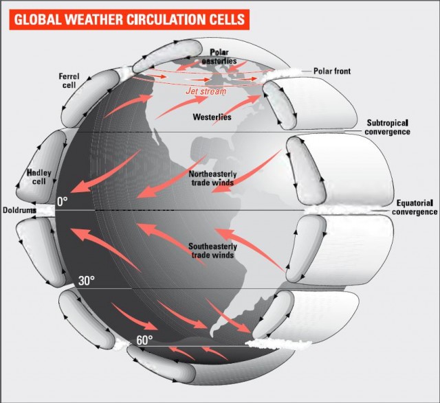
Here the jargon shifts from Hadley cells to Ferrel cells, and America takes over from England and France. US scientist William Ferrel pointed out that the temperate westerly winds that make large areas of Europe.
North America and Asia so habitable by humans have essentially the same cause as the Trade Winds nearer the Equator. The combination of Coriolis Force and pressure ditterences means that these winds set off to the north-east in the northern hemisphere and to the south-east in the southern. As Ferrel also appreciated, and as we shall see in the next chapter, major ocean currents such as the Gult Stream, which crosses the Atlantic from south-west to north-east, have the same origin.
The winds of the Ferrel cells are gentler than those involved in the equatorial Hadley system. As they cross the Atlantic and the Pacitic, the air they carry becomes saturated with water, so that when they make landfall, the areas they encounter, such as Scotland and British Columbia, have some of the highest rainfall on the planet.
It might seem that there is nothing to stop this airflow going all the way to the North and South Poles. But it does not. The reason is that the polar regions have their own set of airflow cells, doing more or less the exact opposite of the Hadley cells.
To help remember all this, just thank the ancient Babylonians who devised the system of chopping up circles into 360 degrees. The first and hottest part of the lower atmosphere in the shape of the Hadley cells runs from the Equator to about 30° north and south. The Ferrel cells are found between about 30° and 60° in each hemisphere, while the polar cells run from about 60° to the pole.
The polar cells form because the extreme cold causes air to descend in the region of both poles. This air is very dry. Despite all that snow – which has built up over millions of years – the South Pole is in a desert. In the northern hemisphere, the Eismitte weather station in Greenland has 111mm of precipitation a year, less than half the 250mm generally regarded as the threshold below which an area is regarded as a desert. This air lands and is pushed towards the Equator by more air coming along behind. Having descended at or near one of the poles, it has almost no rotational velocity and as it leaves the polar region it is heaved strongly to the west. This effect creates the easterly winds that ensured it was much easier for the Vikings to discover America than it was for them to get home again.
When these winds get to about 60° latitude, they collide with the westerlies of the Ferrel cells, forming the polar front. The resulting high pressure shoves the air upwards, where it divides, with halt heading back to the pole and the rest towards the subtropical convergence, completing the cells.
The difference in temperature between air in the polar cells and that in the Ferrel cells produces one of the atmospheres most spectacular phenomena, the jet stream, or rather many jet streams. These winds are found about 10km above sea level, blowing more or less exactly from west to east under the influence of the Coriolis Force, and at speeds of up to 300kph. Their discovery is a boon to international air travel. Planes going the same way as the jet stream go to some trouble to enter it, making the journey faster and using less fuel. By the same logic, flights heading west are routed away from the jet stream. There are also jet streams above the subtropical convergences between the Hadley and Ferrel cells. But these are far weaker, both because the Coriolis Force is less severe closer to the Equator and because the temperature differences between tropical and subtropical air are less violent than those between polar and subtropical conditions.
The explanation that this account gives of the general features of the Earths weather machine is a good one. But it is by no means complete. In particular, the cells are not hermetically sealed off from each other. Smaller-scale eddies and vortices cut across their boundaries, and transfer energy from the equatorial zones towards the poles. As the poles get only 40 percent as much solar energy as the Equator, this energy flow is useful for keeping the polar regions even as warm as they are.
Earth gets in the way
If things were this simple, we could save several minutes a day by abolishing the weather forecast. It would be hotter in the summer, colder in the winter, and somewhere in between in spring and autumn, in a more or less completely predictable way.
The main reason matters get complicated is the solid – and indeed liquid – Earth below all this air. The land and sea have influences on the climate and weather that wre all experience. One is that air cannot flow' across the land without rubbing against it. The “friction layer” or “boundary layer” extends several hundred metres above ground level. Nor is the effect simple. Depending how rugged the landscape is, there can be eddies and turbulence hundreds of metres high and wide at big landscape features, whether natural like mountains or artificial like tower blocks.
Over 70 percent of the Earths surface is ocean, and the entire ocean surface is in contact with the air. As we have seen, air that rises high in the atmosphere and then descends to the surface contains too little water vapour to produce much rain, hence the deserts of the tropics and poles. But when air is pushed across the ocean for a few thousand kilometres, it cannot help absorbing water. In many cases it will get close to being “saturated”, a state in which it cannot take in any more. However, the amount of water that a given volume of air can absorb depends on its temperature and pressure. When the wind arrives on land, things can change fast, especially if the land that it finds is mountainous. Then the air is driven uphill, where the pressure falls and the temperature does too. These factors both point in the same direction – reduced water-bearing capacity for the air, and shops down below' well stocked with umbrellas. For example, Vancouver in Canada has annual rainfall of 1117mm, according to the refreshingly honest website of the Vancouver tourist authority, because the city is the target of westerly winds that have crossed the worlds biggest ocean to get there. The same is true of Fort William in Scotland. Fort Bill is the small town at the foot of Ben Nevis, the biggest mountain in the British Isles, and firmly in the path of air that has just crossed the Atlantic. It has 1935mm of rain per year.
However, there is better newrs for anyone slightly behind the line of fire. At Inverness, on the opposite (east) coast of Scotland, and only around 100km from Fort William, annual rainfall is a comparatively bearable 640mm. This zone is called the rain shadow.
The many ways in which land shapes can influence weather are celebrated in names applied all over the world to local weather systems. For example, there are many variants of the type of wind known as a foehn, which is the opposite of the rain-dropping winds of coastal mountain regions. When that air has risen, cooled and deposited rain, it can run down the opposite slope, warming and gaining force. In the Rocky Mountains, this wind is often called a chinook or snow-eater as it can raise temperatures by up to 15°C in less than an hour. That sounds OK, until you see the floods that result as the snow melts.
In southern California, the wind that is steered through dry desert canyons is termed the Santa Ana, and it gives regions many kilometres inland a climate more akin to that of the coast. In the colder climates further north, in British Columbia, fjords facing east-west can trap a wind called the squaniish which blows cold air in severe storms, but dies out offshore when the cliffs are not there to shape it.
Another set of local weather effects arises from the different thermal properties of sea and land. The land warms up more rapidly than the water when the sun shines on it. That is why jumping in a lake feels refreshing on a hot day. In the morning, as the land warms up and the sea stays comparatively cool, the air above the land gets heated faster than the air over the sea and rises, causing a wind to blow in from the sea to replace it. In the evening, the land will cool faster than the sea, and the wind will blow' towards the shore. Either way, these winds are normally mild and are called sea breezes.
However, the comparative properties of land and water on a larger scale are less benign. Because land masses gather heat in huge amounts in summer, and shed it in even greater amounts in winter, the centre of a continent is always a more extreme place to live, weather-wise, than the coast. From Moscow to Chicago, people who live far from the oceans get comparatively little rain, but pay for their pleasure in sweltering summers and freezing winters. Moscow is often frozen right through from November to April, but the temperature can reach 30°C in the summer.
The upshot is that for a happy weather existence, you should opt to live somewhere that is not too near the poles or the Equator, and is near to a body of water, ideally on the scale of a sea rather than an ocean. In other words, you should live near the Mediterranean.
In honour of this fact, the Mediterranean climate is regarded by the experts as being to the weather what the Mediterranean diet is to food – civilized, temperate, not too extreme, enjoyable and conducive to a long life. It is found around most of the Mediterranean, but also in and around Perth in western Australia, in northern California, in New Zealand and in coastal parts of Chile. Most of these regions are on the western edges of continents, so they get enough rain through the year for prosperous agriculture, although their summers stay dry.