Volga River
THE VOLGA RIVER is considered to be the mother of Russian rivers. Europe's longest, it drains an area of 550,288 square mi (1,410,994 square km), roughly 40 percent of European RUSSIA. From its origins in the heavily forested hills near the Baltic Sea to its mouth on the CASPIAN SEA 2,300 mi (3,700 km) away, the river passes through much of the heart of historic Russia.
The course of today's Volga has been significantly altered by the creation of a succession of hydroelectric dams and enormous reservoirs, built by the Soviets between the 1930s and 1960s. The largest of these, the reservoir of Samara (known in Soviet times as Kuybuyshev), backs up waters of both the Volga and its chief tributary, the Kama, for 375 mi (600 km), covering an area of 2,300 square mi (5,900 square km). The river is now a chain of inland seas with sluggish currents and brown murky waters. The dams and reservoirs, though under heavy attack from environmentalists, continue to provide electricity and irrigation to vast regions of central Russia, while its waterways, locks and canals are important as Russia's largest inland water transportation network, carrying roughly two-thirds of all river commerce. Boats can travel nearly the entire length of the river and by means of canals, can connect to other river networks, thus linking the Volga basin to the ATLANTIC and the MEDITERRANEAN via the Baltic and BLACK seas.
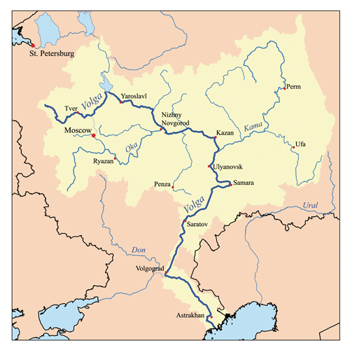
For much of Russian history, the Volga has served as a boundary between east and west, between Slavs and Orthodox Christianity, and the nomadic “barbarians” of Siberia and the steppes of Central Asia. Cities like Kazan and Astrakhan began as Mongol strongholds, but were taken by Russian forces during the 15th-century expansion eastward. New cities were built on its lower courses, such as Tsaritsyn (the city of the tzar), which was later renamed Volgograd, then Stalingrad, site of one of Russia's bloodiest battles in World War II. The ancient Russian capital of MOSCOW is not on the Volga itself, but the Moscow River flows into its second-largest tributary, the Oka River. A canal was built in 1937 to make Moscow a port for the first time in its long history.
The Volga is remarkably flat from source to mouth, dropping only 630 ft (190 m) from the Valdai Hills (roughly halfway between Moscow and SAINT PETERSBURG) to the depression of the Volga Delta at the Caspian Sea. This depression is one of the lowest spots in Europe, falling to 92 ft (28 m) below sea level. The climate and vegetation change dramatically along the river's course, however, from dense northern forests to steppe and semidesert in the south. The last segment of the river (below Volgograd) actually has less flow per second (dropping from a high of 295,814 cubic ft or 8,380 cubic m per second), because of the lack of tributary streams and high evaporation from the sun. The river's delta is wide and is home to one of Russia's prime exports, caviar from enormous Volga sturgeon. This industry and others are disturbed by environmental problems: heavy metallic content in the reservoirs and drop in water levels due to irrigation and evaporation. There is growing concern among the 60 million people and about half of Russia's industry and agriculture that depend on the river.