Amazon River
SOME AUTHORITIES believe that the river in BRAZIL and neighboring countries was named after the Amazons, women warriors of Greek mythology, who were thought to reside in the region; other scholars insist that the name is derived from the local native word amassona, meaning “boat destroyer.” Despite centuries of effort to overcome the dominance of nature, people have made little impact on the Amazon and most of its vast drainage basin. No bridge spans the river. Except near its mouth, the Amazon watershed constitutes one of the most thinly populated regions in the world. Much of the territory drained by the river system has never been thoroughly explored. One may fly for hours over the tropical forests that cover much of the river's FLOODPLAIN and see no sign of human settlement. In many valleys, native tribes remain hostile to strangers, continuing to live much as they did before the arrival of the Europeans.
BASIN GEOGRAPHY
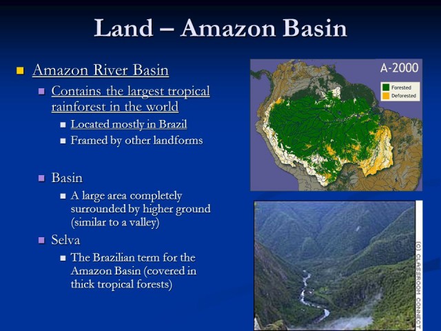
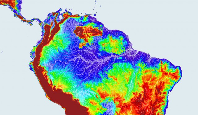
The Amazon Basin is a vast structural depression covering approximately 2,722,000 square mi (7,049,800 square km), an area nearly as large as the continental portion of the UNITED STATES. It is twice as large as the world's next largest drainage BASIN (the CONGO RIVER), and supports the world's largest rainforest. Geologically, two large stable masses of Precambrian rock, the Guyana Shield or Highlands to the north and the Central Brazilian Shield or Plateau to the south, bound the Amazon River and basin. Some 15 million years ago, before the ANDES MOUNTAINS were formed, the Amazon River flowed westward into the PACIFIC OCEAN. With the uplift of the Andes Mountains, however, the course of the river was eventually blocked to the west. As the river system backed up, the environment of the Amazon basin changed and numerous freshwater lakes began to form an inland sea. Ultimately, the gradient and volume of water was sufficient to push the flow to the east toward the ATLANTIC OCEAN where it empties today.
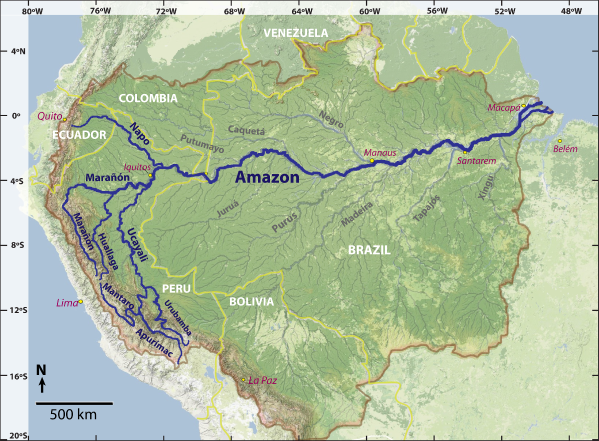
Most sources list the Amazon as 4,080 mi long (6,580 km), making it second to the NILE in length. However, there is some debate about the length of the Amazon versus Nile depending on the actual starting point of the source. According to recent discoveries, the Amazon is 4,195 miles (6,712 km) long if the course follows the Apurimac branch (rather than the Urubamba branch) of the Ucayali to a point 17,200 ft (5,242 m) above sea level, making it 50 mi (80 km) longer than the Nile. The Ucayali and Maranon rivers, both of which rise in the permanent snows and glaciers of the high Andes Mountains, flow along roughly parallel courses to the north before joining near Iquitos, Peru. Beyond Iquitos the river turns abruptly eastward, flowing along a very gentle gradient (approximately 1.25 in or 3.2 cm per mile) more or less paralleling the equator as it meanders over lowland plains. At Manaus, approximately 1,000 mi (1,610 km) upstream from the coast, the elevation is only 100 ft (30 m) higher than Belem, which is an ocean port.
The northern half of the South American continent is shaped like a shallow dish. More than 1,000 tributaries, seven of which are more than 1,000 mi (1,613 km) long, flow through nine South American countries (Brazil, BOLIVIA, PERU, ECUADOR, COLOMBIA, VENEZUELA, GUYANA, SURINAME, and FRENCH GUIANA) that contribute waters to this dish. Beyond the riverbanks there are broad, swampy floodplains covered with lush, periodically flooded forests.
Throughout most of the Brazilian part of the river, the channel exceeds 150 feet (50 m) in depth, although some parts near the mouth have been recorded to be as much as 300 feet (91 m) deep. Discharge at the mouth of the Amazon is approximately 7,733,000 ft cubed per second (219,000 meters cubed per second), nearly five times the volume of the Congo and roughly equal to the volume of all the other major rivers of the world combined. At some points, the Amazon is 1 mi (1.6 km) wide, while at other points during the flooding season it can be 35 mi (56 km) wide or more. At Belem, where the waters flow into the Atlantic Ocean, it can be 200 to 300 mi (322 to 483 km) across, depending on the season and including the river's influence along the coast.
At Iquitos in Peru, the furthest point up river for major navigation by ship, the river also changes its name. From Iquitos to the junction of the Rio Negro near Manaus the river is known locally as the Solimoes, while from Manaus to the sea it is referred to as the Amazon.
CLIMATE
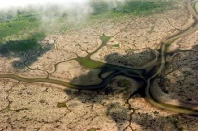
Over most of this vast region the CLIMATE is very warm and humid. Rain falls about 200 days each year, and rainfall totals often exceed 80 in (204 cm) per year. One result of so much rain is that the Amazon is subject to seasonal floods. Tributaries flowing from the south tend to flood from February to April, while those coming from the north reach flood peaks between June and July. As these waters make their way to the sea, the waters of the Amazon vary in color depending on the soils and rocks they pass over. Some of the tributaries are home to “white” waters, although their color is more often a murky yellow or tan than white. The white rivers originate from runoff in the Andes, and their turbidity results from the heavy loads of mud and silt they carry.
Waters in so-called black rivers, on the other hand, come from areas where the water flows over ancient rocks where there is little sediment remaining to be washed away. The black rivers are dark because only dissolved organic matter stains their clarity. Clearly the most dramatic union of black waters with white occurs at Manaus, where the black waters of the Rio Negro and the ochre-tinted Rio Solimoes meet. Locally known as the Encontro das Aguas (Wedding of the Waters), the waters run side by side for miles before they finally mix.
There is some evidence suggesting that the lower Amazon may once have been an ocean gulf, the upper waters of which washed the cliffs near Obidos some 600 miles (966 km) from the coast. The effects of the ocean are still felt at Obidos. Because of the gentle slope of the land, tides are able to penetrate this far upstream. Here the tidal phenomenon called the bore, or Pororoca, occurs. Often up to 12 ft (3.7 m) high, it begins with a roar, constantly increasing as it advances at a rate of from 10 to 15 mi (16 km to 24 km) an hour Beyond the point where the Zingu River joins the Amazon from the south, the main channel splits into a maze of smaller channels with numerous large islands. Marajo, the biggest island in the delta, is about the size of Vermont and New Hampshire combined. Finally, beyond its several mouths, the Amazon merges with the sea just above the equator where ocean currents bend it northwestward along the coast ultimately becoming part of the South Equatorial Current.
THE RAINFOREST
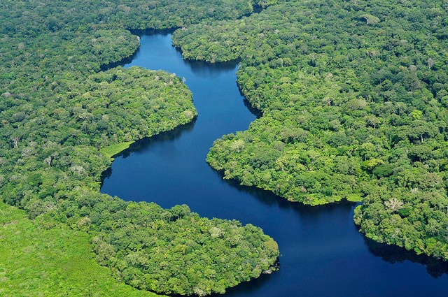
The Amazon rainforest, also known as Amazonia, is the largest tropical rainforest in the world, covering more than half of Brazil. It is also one of the world's greatest natural resources, containing the largest single reserve of biological organisms in the world. No one really knows exactly how many different species inhabit the area, but scientists estimate there are between 800,000 and 5 million, amounting to 15 to 30 percent of all the species in the world. Because its vegetation continuously recycles carbon dioxide into oxygen, it is often referred to as the “Lungs of our Planet.”
The Amazon Rainforest consists of four layers or communities. Each layer has unique ecosystems, plants, and animals adapted to that system. The emergent layer is the tallest layer, where trees can be as tall as 200 ft (61 m) and rise well above the canopy. Here they are exposed to fluctuation of temperature, wind, and rainfall. The leaves are small and covered with a thick waxy surface to hold water. They take advantage of the wind by developing winged seeds that are blown to other parts of the forest. Trunks can be up to 16 ft (4.9 m) around and braced by massive buttress roots. Some of the animals find everything they need to survive in the emergent layer and never leave it.
The main layer of the rainforest is the canopy. Most canopy trees have smooth, oval leaves that come to a point, known as a drip tip. This allows water to flow off the leaf quickly and prevents the growth of fungi, mosses, and lichens. The canopy's leaves are very dense and filter out about 80 percent of the sunlight. Many flowers and fruits grow in this layer. Epiphytes cover every available surface and bromeliads provide drinking water for the many canopy creatures and breeding pools for tree frogs.
Some of the animals found in the canopy are the harpy eagle, which preys on monkeys, kinkajous, sloths, reptiles, and other birds. Sloths spend most of their lives in the treetops. Their diet of low-nutrition leaves forces them to conserve energy, causing the sloth to spend 80 percent of its life resting. A large portion of a howler monkey's diet consists of leaves that are hard to digest. Their metabolism is so low that they need to warm themselves up in the sunlight after a chilly night. Leaf-cutter ants are responsible for harvesting a sixth of the area's leaves, bringing leaf fragments to their underground nests. They play a critical role in the rainforest's ecosystem by pruning the vegetation, which stimulates new growth, and breaking down the leaves to renew the soil.
The understory receives only a small amount of the available sunlight. Plants must find unique ways to adapt to this shadowy existence. Their leaves tend to grow large and are darker green than the leaves found in the main and emergent layers. Vegetation in this zone also tends to be relatively short, growing little more than 12 feet in height. Because there is very little air movement in this zone, the plants must rely on insects and animals to pollinate their flowers. Accordingly, the flowers and fruits of plants in this zone are usually quite large and grow low on the trunks. The lack of wind and abundant sources of flowers and fruits also makes this the layer with the largest concentration of insects.
The forest floor is the lowest layer. It has relatively few plants since only 2 percent of the available sunlight filters through to this level. The floor is littered with decomposing vegetation and organisms that break it down into usable nutrients. Many nutrients are locked into this biomass. Tree roots stay close to the surface to access these nutrients rather than penetrating very far into the soil. Large animals forage for roots and tubers, while insects like millipedes, scorpions, and earthworms use the litter as a source of food.
PIRANHAS
Naturalists suggest there may be as many as 3,000 different kinds of fish in the Amazon's rivers and lakes. Among these are some of the biggest fish outside the ocean. Among the fish found in the area are the pirarucu, said to be the largest freshwater fish in the world, with some specimens measuring over 6.5 ft (2 m) in length and weighing 275 pounds (125 kg); the tambaqui, which have teeth that can crack seeds as hard as those of the rubber tree and the jauari palm; and the piranha. The ferocity of the meat-eating piranha has been exaggerated. Although it is true that some species have killed large animals and even people, their behavior depends on the state of their habitat and violence toward humans is a rare circumstance. In main river channels and in larger lakes with plenty of food available, they generally pose no threat to swimmers. They appear to become aggressive only when they do not have enough nourishment.

Over 500 mammals, 175 lizards and 300 reptiles species, and one-third of the world's birds live in Amazonia. It has been estimated that about 30 million insect types can be found here. Competition for survival is fierce, with the most intense competition taking place between animals and plants.
Despite the abundant riches, the giant trees that grow within the rainforest structure also grow in some of the world's poorest (least nutritious) soils, with the top two inches containing 99 percent of the nutrients. Nine-tenths of the forest's energy is stored in the leaves and tissues of the trees themselves. As soon as a tree falls, decomposers begin to turn it into a food source, as the vegetation to renew the cycle quickly absorbs the nutrients that are released. Because the rainforest ecosystems are the most efficient in all of nature, the destruction of one part of the system can spell the destruction of the whole system.
The climate throughout Amazonia is about the same throughout the year, and the difference between day and night time temperatures is usually greater than that between seasons. Temperatures are warm and humid, averaging around 79 degrees F (26 degrees C).
EXPLORATION AND ECONOMY
There is archaeological evidence of clustered, densely populated pre-Colombian settlements in parts of the Amazon basin, but at the time of the early European explorations, these settlements had already been wiped out, probably by smallpox and other diseases. The Amazon was probably first seen by Europeans in 1500 when the Spanish commander Vicente Yanez Pinzon explored the lower part. Real exploration of the river came with the voyage of the Spanish explorer Francisco de Orellana in 1540–41. Not long afterward (1559) the Spanish conquistador Pedro de Ursua led an expedition down from the Maranon River. In 1637–38 the Portuguese explorer Pedro Teixeira led a voyage upstream that ultimately opened the Amazon. The valley was largely left to its sparse remaining indigenous inhabitants until the mid-19th century, when a few settlements were started and steamship service was established.
In the late 19th and early 20th centuries, the wildrubber boom on the upper Amazon attracted settlers from Brazil's northeastern states, while Japanese immigrants began developing jute and pepper plantations in the 1930s. Until recently the area has remained largely unpopulated, yielding small quantities of forest products (rubber, timber, vegetable oils, Brazil nuts, and medicinal plants) and cacao. Extensive road networks are now opening the land to colonization, although agricultural success has been limited by adverse climate, poor soils, and the lack of nearby markets.
In the 1960s, the Amazon region began experiencing increased economic development brought on by tax incentives to settle in the west from the Brazilian government and construction of the Trans-Amazon Highway, the Belem-Brasilia Highway, and two rail lines. Near Manaus and Amapa, factories are making use of the areas oil and manganese resources.
The Brazilian government implemented a “poles of development” policy in 1974 to plan for population increases in the west. Since 1985, the Carajas project has seen the development of major iron ore deposits, the construction of a new railroad, and the initiation of forest clearance, land colonization, cattle ranching, large-scale farming, and urban development on an unprecedented scale. This policy has had mixed results, however, with significant environmental damage and disruption of native inhabitants' lives. Over the past 30 years, government-sponsored road-building projects, colonization schemes, and industrial developments have transformed large areas of Amazonia from pristine forest to polluted factory sites and sprawling settlements.
In spite of the numerous development programs, the economy through most of the basin continues to be dominated by primitive agriculture, hunting and fishing, and the gathering of various forest products. Commercial farming, tourism, and industry play only a minor role in the region, but manufacturing, mining, and lumbering, the principal economic activities, are increasingly important.
MAJOR CITIES
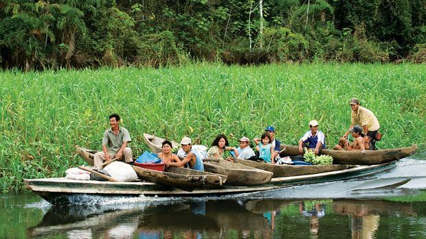
Although there are a few sizable cities along the river's banks and scattered settlements inland, Amazonia is largely uninhabited. Here and there, plantations have been cleared in the jungles, and natives ply the streams in search of latex and Brazil nuts. But mostly the great green luxuriant rainforest is still pristine wilderness, one of the few large areas left on Earth where nature's creation remains more or less unspoiled and intact.
For 350 years after the European discovery of the Amazon by Pinzon, the Portuguese portion of the basin remained an almost undisturbed wilderness. It is doubtful if its indigenous inhabitants ever exceeded one to every 5 square mi (13 square km) of territory. A few early settlements on the banks of the main river and some of its tributaries had been founded by the Portuguese, either for trade with the Indians or for evangelizing purposes. The total population of the Brazilian portion of the Amazon basin in 1850 was perhaps 300,000, of whom about two-thirds were white and slaves, the latter numbering about 25,000.
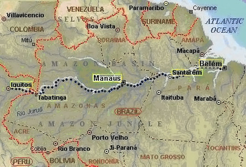
Manaus, the largest early settlement along the Amazon, is once again one of Brazil's major cities. Although located 1,200 mi (1,931 km) from the Atlantic, it is a port city with a population of 750,000. Manaus is downriver from the famed “Wedding of the Waters,” or Encontro das Aguas, where the dark Rio Negro and the ochre-tinted Rio Solimoes meet and run side by side for some miles before they finally mix. The city was built during the rubber boom, when the Amazon had the only rubber trade in the world. The city enjoyed unbelievable wealth through the turn of the 20th century, with lavish living, splendid buildings, and huge plantations springing up out of the jungle. The rubber trade created a thriving city that attracted entrepreneurs from the United States and Europe. Ultimately, traders found a way to take some of the plants to India and started growing them. With new sources of rubber, the market became oversaturated and eventually collapsed, leaving the cities tied to the rubber trade with the same fate. Today, the city is busy because of government programs encouraging development of Brazil's west, a duty free zone, and the creation of an active tourist industry.
Belem, the largest of the three major river cities, is located on the Para River, a tributary of the Amazon near the mouth of the Amazon. Belem was founded in 1616 as a fort. During the rubber boom the city was a hot spot of European culture. A port city, it is the capital of the state of Para. The market place in Belem, Vero-O-Peso, is the largest in Brazil.
Iquitos holds the distinction of being the world's most inland seaport and is accessible only by land or by water. It is the fourth largest city in Peru and the third largest port city on the Amazon. Founded in the 1750s as a Jesuit mission, Iquitos boomed during the rubber days. But the end of the rubber boom in 1920 left the town almost deserted. Today Iquitos is an export center for live animals and aquarium fish, an oil center, and the staging spot for tourism It also has the largest floating market on the Amazon.
ISSUES AND CONCERNS
Today, more than 20 percent of the Amazon Rainforest has been destroyed. The land is being cleared for cattle ranches, mining operations, logging, and subsistence agriculture. Some forests are being burned to make charcoal to power industrial plants. Because rainforest soils are heavily leached, they lack the ability to sustain agriculture for more than a few seasons. Once cut, for whatever reason, a rainforest is likely gone forever. With its passing go untold numbers of species yet discovered as well as habitat and diversity for those that remain. The loss of rainforest also impacts indigenous people by eliminating the hunting and gathering habitat that has sustained them for thousands of years. Today there are fewer than 200,000 indigenous peoples left in Amazonia, and more than 90 tribes have been destroyed since the 1900s
Indigenous peoples have also used different plants as cures and potions for their health and survival. Many of our current pharmaceuticals are based on medicinal chemistry derived from the plant kingdom. Today more than 100 prescription drugs come from plant-derived sources. And although only 25 percent of all drugs are derived from rainforest ingredients, scientists have tested only 1 percent of the potential number of tropical plants that could be available.
In the 1980s, under pressure from international conservation groups, Brazil started to ensure that development efforts in the Amazon did not irrevocably compromise the forest resources. Although recent discoveries of oil and gas have placed increasing pressures on the natural wealth of Amazonia, the Brazilian government has been active in promoting sustainable exploitation policies to manage the Amazon's huge resource reserves. Environmental monitoring and licensing systems have been set up along with national parks to conserve the flora and fauna. Additionally, the rights of Indians and their way of life have been recognized and protected within the reserve system.