Amur River
THE AMUR RIVER, in Siberia, springs from the confluence of the Shilka and Argun Rivers east of Lake BAIKAL and flows over 1,800 mi (2,897 km) toward the Tatar Straits, the passage between Sakhalin and the Russian Pacific Coast. With all tributaries, the Amur basin covers nearly 750,000 square mi (1,942,491 square km) of area. The Russian push into the river valley in the mid-17th century resulted in a border clash with the Chinese Empire. The Treaty of Nerchinsk (1689) admitted the territorial sovereignty of the Manchu dynasty over the Amur region for 150 years. The Chinese know the river as the Heilongjiang. In the mid-19th century, the Amur, as the lone river in Siberia that flows eastward to the PACIFIC OCEAN, gained geopolitical significance for the Russian Empire. After the unequal treaties concluded with CHINA in 1850 and 1860, RUSSIA annexed the Amur region.
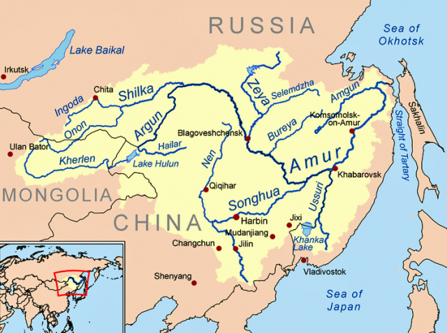
Russian 19th-century geographers spoke of the Amur as Russia's gateway to the Pacific. Not only is the river is abundant with fish, but also the mild climate is appropriate for agriculture (grain, vegetables, fruits). A systematic geographical exploration of the river by the Russians began in 1824 with Grigorii Spasskii's study “Historical and Statistical Notes about Places along the River Amur.” In 1846, navigator Alexander Gavrilov sailed to the mouth of the Amur and reported that the river was too shallow for even small ships. This was revised by Gennadii Nevel'skoi's expedition in 1849 that found that the mouth of the Amur was navigable by ships of any size.
The Russian government feared a British occupation of the river mouth and the east Siberian general governor, Nikolai Murav'ev-Amurskii, coined the Russian geopolitical logic that whoever shall control the mouth shall control Siberia to Lake Baikal. In 1856, the tzarist government declared the Amur region a free trade zone. After the emancipation of the serfs (1861), the government supported the free colonization with tax exemptions. Though some thousands of peasants settled along the Amur, the region remained underpopulated until the modern era.
In view of the illegal migration between 1860 and World War I, the tzarist government founded the socalled Amur Cossack Division, which supervised the border line along the river. In the Russian Civil War (1917–22) Japanese troops occupied the Amur region. Again in the 1930s and in the late 1960s, the Amur became a military trouble spot between the Soviet Union and its East Asian neighbors, JAPAN and China. In the era of Sino-Soviet confrontation, the Soviet government created a frontier ethos that was, at least, reflected by the construction of the BAM (Baikal-Amur-Magistrale). After the breakdown of the Soviet Union in 1989, the Amur region experienced a population outflow to European Russia that resulted in a declining industrial production. Nevertheless, the Amur region seeks economic cooperation with nearby China and facilitates border trade between the cities Blagoveshchensk and Heihe.