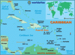
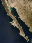
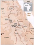
Puerto Rico
THE ESTADO LIBRE Asociado de Puerto Rico is a densely populated island in the eastern Greater Antilles in the CARIBBEAN SEA, divided into 78 counties. Even though it is a possession of the UNITED STATES, Puerto Rico is an independent commonwealth and has selfgovernance in all its local affairs. The rectangularshaped, mostly mountainous volcanic island […]
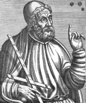
Ptolemy
KLAUDIOS PTOLEMAIOS, known as Ptolemy in English, lived in Alexandria, EGYPT, in the second century C.E. He is considered one of the most important scientists of the later Classical era, with two major treatises in the areas of astronomy and geography. His geocentric model of the universe was the standard accepted view of the cosmos […]
projection, maps
THE EARTH CAN BE assumed as a perfect sphere for purposes of simplicity. However, in reality there is a large difference between the pole-to-pole distance and the equator distance. The Earth is about 1/300th smaller in its pole to pole distance. This unique shape is called an oblate ellipsoid or spheroid. An estimate of the ellipsoid […]
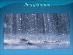
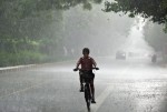
precipitation
PRECIPITATION IS WATER falling from clouds. In the tropics, rain is the common form. In colder climates, precipitation also falls as snow, sleet, or hail, if the air temperature is 32 degrees F (0 degrees C) or less. Water's descent from clouds begins when the size of water droplets or ice crystals becomes large enough for […]
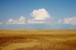
prairie
BEFORE NORTH AMERICA was populated by settlers who developed the land, most of the continent was covered by flat grass-covered areas known as prairie, stretching from CANADA to MEXICO. By the beginning of the 21st century, 99 percent of the original prairie had been destroyed. The provinces of Alberta, Saskatchewan, Manitoba, and Ontario are part […]
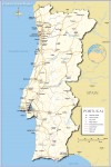
Portugal
Area 35,672 square mi (92,391 square km) Population 10.40 million 2014 Capital Lisbon Highest Point Pico 7,713 ft (2,351 m) Lowest Point 0 m GDP $229.6 billion 2014 Primary Natural Resources forests, cork, marble, fisheries. THE PORTUGUESE REPUBLIC is located in southwestern Europe, sharing the Iberian Peninsula with SPAIN, which it borders to the north […]
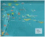
Polynesia
POLYNESIA, MEANING “many islands” (Greek), is one of the three main divisions (the others being MICRONESIA and MELANESIA) of Oceania. This division is based upon the ethnological background of the different islands' inhabitants. Geographically, Polynesia is a triangle area of islands, with the Hawaiian Islands at one corner, NEW ZEALAND at another, and EASTER ISLAND […]

Polo, Marco (1254–1324)
MARCO POLO IS THE best known of all Western travelers along the SILK ROAD. He traveled Asia for 24 years, all the way to CHINA, where he became confidant of Kublai Khan (1214–94.) He also wrote of his travels. Marco was born in ITALY, either in Curzola off the Dalmatian coast or in Venice, in […]
political geography
POLITICAL GEOGRAPHY IS the study of the ways geographic space is organized within and by political processes. It focuses on the spatial expression of political behavior. Boundaries on land and on the oceans, the role of capital cities, power relationships among nation-states, administrative systems, voter behavior, conflicts over resources, and even matters involving outer space […]
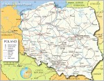
Poland
Area 120,728 square mi (312,685 square km) Population 38.00 million 2014 Capital Warsaw Highest Point 8,199 ft (2,499 m) Lowest Point -6.6 ft (-2 m) GDP $548.0 billion 2014 Primary Natural Resources coal, sulfur, copper, natural gas, silver. POLAND IS LOCATED in eastern Europe, and is surrounded by the Baltic Sea to the northwest, GERMANY […]
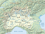
Po Valley
THE PO RIVER VALLEY is the largest and most important economic region in ITALY. It is the center of most Italian industry as well as Italy's agricultural heartland. More than 16 million people—nearly a third of all Italians—live in this fertile basin, in which are located 12 cities with populations surpassing 100,000, including Turin and […]
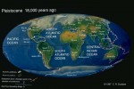
Pleistocene geography
THE PLEISTOCENE EPOCH was Earth's most recent Ice Age. The epoch began around 1.8 million years ago (mya) or 2.6 mya. Traditionally, scientists have based the starting date of the epoch on faunal grounds and have estimated it to be about 1.8 mya. A growing number of climate scientists and glaciologists tend to use 2.6 […]
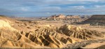
playa
PLAYAS ARE SHALLOW basins that periodically fill with rainwater. They have been described as among the most dynamic geomorphic features, reacting to seasonal and sometimes daily changes in the environment. The term playa owes its origin to the Spanish word for “beach” or “shore.” A large number of playas began as lakes, drying later as […]
plateau
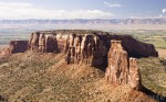
A PLATEAU IS A LARGE area of mostly level land elevated high above the surrounding land. Most plateaus have one steeply cliffed side. The rock layers in a plateau are un-deformed and remain flat, unlike the rock layers in mountains, which are tilted. Basaltic plateaus are formed when molten rock forces its way up through […]
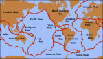
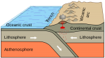
plate tectonics
PLATE TECTONICS IS A geological theory that explains many important features of the Earth's surface through the movement of sections of the crust, known as plates. Among the observed data explained by plate tectonics are the known similarities of features on the east and west sides of the ATLANTIC OCEAN, similarities of plant and animal […]
planning
WHILE PLANNING IN ITS MOST literal form refers to the creation of a plan in an urban context, in reality the term has a far broader and more complicated definition. For example, planning can refer to matters of safety, that is, the prevention of natural disaster, as well as issues such as aesthetics, the environment, […]
place
NOTHING IS MORE important to all geography, descriptive or analytical, natural or human, than place or location. Place can be divided into at least three distinct aspects: geometric location defined by precise latitude and longitude; relative location of where a place is relative to other places, especially in the context of history; and finally, the […]
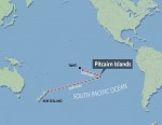
Pitcairn Island
PITCAIRN (18.1 square mi or 47 square km) is an isolated island located in the east-central PACIFIC OCEAN, approximately 400 mi (644 km) southeast of Mangareva, the closest inhabited island. Pitcairn is the only inhabited island of the British colony of Pitcairn, Henderson, Ducie, and Oeno Islands. The three outer islands of the Pitcairn Islands […]
physical geography
PHYSICAL GEOGRAPHY IS AN integral part of a much larger area of understanding called geography. Most individuals define geography as a field of study that deals with maps. This definition is only partially correct. A better definition of geography may be the study of natural and human phenomena relative to a spatial dimension. The discipline […]
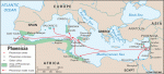
Phoenicia
ANCIENT PHOENICIA, A LOOSE confederation of city-states existing between 3000 B.C.E. and 146 B.C.E., was located where LEBANON is now. The culture was known for seafaring commerce and trade, and colonizing. The most important legacy left by the Phoenicians, though, was a 22-character alphabet that became the basis of Hebrew, Greek, and Roman script. In […]
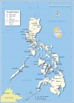
Philippines
Area 115,831 square mi (300,000 square km) Population 99.14 million 2014 Capital Manila Highest Point 9,691 ft (2,954 m) Lowest Point 0 m GDP $284.6 billion 2014 Primary Natural Resources timber, petroleum, nickel, cobalt, gold. OFF THE SOUTHEAST COAST of mainland Asia lies the Philippines, a southeast Asian country that consists of an archipelago in […]
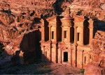
Petra
PETRA HAS BEEN described in National Geographic magazine as being “JORDAN's city in the rock.” There is no doubt, however, that Petra, located south of Amman on a semiarid site at the edge of the Wadi Araba mountainous desert, is a wonder of the ancient world. Originally developed at the crossroads of overland trading routes, […]
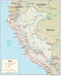
Peru
Area 496,226 square mi (1,285,220 square km) Population 30.97 million 2014 Capital Lima Highest Point 22,205 ft (6,768 m) Lowest Point 0 m GDP $202.9 billion 2014 Primary Natural Resources copper, silver, gold, petroleum, timber, fish, iron. PERU IS A country of contrasts. The fourth-largest country in Latin America, Peru has an amazing geography, a […]
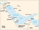
Persian Gulf
THE COUNTRIES BOUNDING the Persian Gulf include OMAN, UNITED ARAB EMIRATES, QATAR (a peninsula off the SAUDI ARABIA coast), BAHRAIN (an island), Saudi Arabia, KUWAIT, IRAQ, and in the north, IRAN. The Persian Gulf is an arm of the ARABIAN SEA extending some 600 mi (970 km) from east to west. It covers an area […]
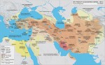
Persian Empire
THE PERSIAN EMPIRE was one of the first of the world empires to emerge in the ancient Middle East, the first to unify several different peoples and cultures into one large heterogeneous state. Much of this work was achieved by the emperors Cyrus and Darius, who recognized the strength of diversity, picking the best of […]
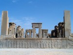
Persepolis
ONE OF THE MOST magnificent cities of the ancient world, Persepolis was the political, cultural, and religious center of the Achaemenian PERSIAN EMPIRE for over 200 years before its complete destruction at the hands of Alexander the Great in 330 B.C.E. The ruins of Persepolis lie at the foot of Kuh-i-Rahmat, the “Mountain of Mercy,” […]
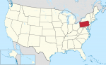
Pennsylvania
THE COMMONWEALTH OF Pennsylvania, also known as the Keystone State, is located in the northeastern UNITED STATES. With a total area of 46,058 square mi (119,290 square km), Pennsylvania extends 307 mi (494 km) from east to west and 175 mi (282 km) north to south. It is bordered by NEW YORK and Lake ERIE […]
peninsula
A PENINSULA IS AN area of land that projects out into a body of water that surrounds it on three sides. Some peninsulas, like Baja California, are joined to the mainland only by a narrow neck of land called an isthmus. Others, such as INDIA, are connected to the mainland by a wide area of […]
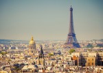
Paris
PARIS IS NOT ONLY the capital city of FRANCE, it is also the largest city in the country. The census of 1999 showed that although the city itself, which covers 40.5 square mi (105 square km), is relatively demographically small by world standards, having a population of about 2.15 million, the greater Paris metropolitan (aire […]
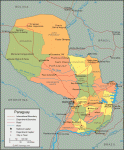
Paraguay
Area 157,047 square mi (406,750 square km) Population 6.553 million 2014 Capital Asuncion Highest Point 2,762 ft (842 m) Lowest Point 151 ft (46 m) GDP $30.98 billion 2014 Primary Natural Resources cotton, sugarcane, soybeans. THE REPUBLIC OF PARAGUAY is a LANDLOCKED country located in the central region of South America bordered by BOLIVIA, ARGENTINA, […]
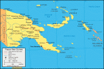
Papua New Guinea
Area 178,707 square mi (462,840 square km) Population 7.464 million 2014 Capital Port Moresby Highest Point 14,793 ft (4,509 m) Lowest Point 0 m GDP $15.41 billion 2013 Primary Natural Resources gold, silver, copper, natural gas, timber. PAPUA NEW GUINEA IS an archipelago that includes the eastern half of the equatorial island of New Guinea, […]
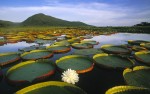
Pantanal
LOCATED IN SOUTH-CENTRAL BRAZIL and extending into the adjacent parts of BOLIVIA and PARAGUAY, the Pantanal is the world's largest wetland. It can expand during the rainy season to cover about 77,000 square mi (200,000 square km), which is about one-third the size of FRANCE. Water depths may exceed 18 ft (6 m), with only the […]
Pannonian Plain
ALSO KNOWN AS the Hungarian Plain, the Pannonian Plain is one of the flattest parts of Central Europe and one of the most agriculturally productive. The plain occupies a wide depression between the Alpine ranges to the west and south and the Carpathian chain to the north and east. At its greatest extent, the plain […]
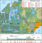
Panama Canal
A CANAL THAT LINKS the ATLANTIC and PACIFIC oceans through the isthmus of PANAMA from northwest to southeast, the Panama Canal is 51 mi (82 km) long. A trip through the canal takes approximately eight hours. The Panama Canal consists of a system of six locks that help ships negotiate the water levels of the […]
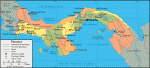
Panama
Area 30,193 square mi (78,200 square km) Capital Panama City Population 3.868 million 2014 Highest Point 11,400 ft (3,475 m) Lowest Point 0 m GDP $46.21 billion 2014 Primary Natural Resources bananas, rice, corn, coffee, sugarcane. The Republic of Panama is a Central American country bordered both by the CARIBBEAN SEA and the PACIFIC OCEAN, […]
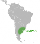
pampas
THERE ARE MANY types of GRASSLANDs worldwide, especially in the continental interiors of temperate to subtropical regions. That of South America is known as the pampas, a Spanish term. The pampas occupies some 270,270 square mi (700,000 square km) in the countries of ARGENTINA, URUGUAY, and southeast BRAZIL. Here, there are extensive plains with isolated […]
Pamir Knot
THE UNIQUE OROGRAPHIC feature known as the Pamir Knot takes its name from the mountains on which it is centered, the Pamir. The “knot” refers to the convergence of some of the world's major mountain ranges, including the TIAN SHAN, Karakorum, Kunlun, HINDU KUSH, and Pamir systems. The origin of the word pamir is unclear, […]
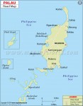
Palau
Area 179 square mi (458 square km) Population 21,100 2014 Capital Koror Highest Point Mount Ngerchel-chuus 798 ft (242 m) Lowest Point 0 m GDP $250.6 million 2014 Primary Natural Resources forests, minerals, gold. PALAU (OR BELAU to its natives) is one of the world's newest nations, finally securing independence (in Free Association status) with […]
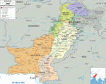
Pakistan
Area 310,413 square mi (803,940 square km) Population 185.0 million 2014 Capital Islamabad Highest Point 28,251 ft (8,611 m) Lowest Point 0 m GDP $246.9 billion 2014 Primary Natural Resources natural gas, petroleum, coal, iron ore. PAKISTAN CAME INTO being in 1947 when British colonial India, upon independence, was divided into Muslim-dominated East Pakistan (BANGLADESH as […]
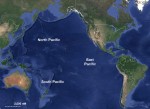
Pacific Ocean
THE PACIFIC OCEAN HAS an area of approximately 68,767,000 square mi (178,106,000 square km) with its adjacent seas; 65,329,000 square mi (169,202,000 square km) without them. As the world's largest ocean, it has the following characteristics. Volume: 160,489,000 cubic mi (674,052,000 cubic km) including adjacent areas; 158,065,000 cubic mi (663,871,000 cubic km) if they are […]
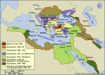
Ottoman Empire
THE OTTOMAN DYNASTY created the most enduring empire in human history. The Ottomans originally migrated from Central Asia as nomads and settled in the early 14th century as a military Turkic principality in western Anatolia (present-day TURKEY), between the frontier zone of the Seljuk state and the Byzantine Empire. The Ottomans emerged into a dominant […]
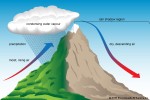
orographic precipitation
OROGRAPHIC PRECIPITATION is caused or enhanced by one or more of the effects of mountains on the Earth's atmosphere. These effects include the upward or lateral motions of air directly caused by mountains acting as a barrier as well as the thermal effects of the mountains that cause them to be elevated heat or cold sources. […]
orogeny
OROGENY, A GEOLOGIC CONCEPT, comes from the Greek oros, meaning “mountain,” and genes, meaning “stemming from.” The etymology associates the term with the concept of building mountains, and in the past, orogeny was associated with mountain formation. Its specific use, today however, relates to the deformation of rocks that leads to postorogenic mountain building. The thrusting, […]
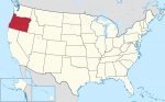
Oregon
OREGON IS A STATE located on the west coast of the UNITED STATES and has a landscape for just about everyone: mountains; FORESTS; plains; DESERTS; the Columbia River Gorge; waterfalls such as Multnomah Falls (620 ft or 189 m), the tallest in Oregon and the fourthtallest in the country; Mills End Park, the smallest park […]
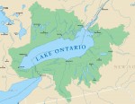
Ontario, Lake
LAKE ONTARIO, BORDERED by the UNITED STATES (NEW YORK state) and CANADA (province of Ontario), is the smallest and easternmost of the five Great Lakes, covering an area of 7,320 square mi (18,960 square km). It is 193 mi (311 km) long and 53 mi (85 km) wide, with a shoreline of approximately 480 mi […]
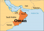
Oman
Area 82,031 square mi (212,460 square km) Population 4.236 million 2014 Capital Muscat Highest Point 9,776 ft (2,890 m) Lowest Point 0 m GDP $81.80 billion 2014 Primary Natural Resources petroleum, copper, asbestos, natural gas. OMAN IS LOCATED in the MIDDLE EAST, bordering the ARABIAN SEA, Gulf of Oman, and PERSIAN GULF, between YEMEN and […]
Olduvai Gorge
OLDUVAI GORGE IS LOCATED in the East African Rift Valley of northeastern TANZANIA, on the eastern edge of the Serengeti Plain. Discoveries of fossils dating back 1.8 million years were made there by Louis and Mary Leakey, and Donald Johansen. The gorge is now part of the Ngorongoro Conservation Area and lies just to the […]
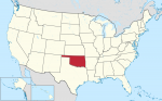
Oklahoma
LOCATED MIDWAY BETWEEN the east and west coasts of the UNITED STATES and just south of the geographic center of the United States in KANSAS, Oklahoma is one of the Great Plains states. The name comes from the Native American Choctaw language as okla meaning “people,” and humma meaning “red.” Despite images to the contrary, […]
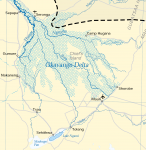
Okavango
COVERING AN AREA roughly the size of CONNECTICUT, Okavango is the largest inland DELTA in the world. It is located in north-central BOTSWANA in the middle of the KALAHARI DESERT and is formed by the Cubango and Cuito rivers flowing out of mountains in ANGOLA and into the Okavango River. Okavango covers a swampy depression […]
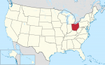
Ohio
OHIO IS A MIDWESTERN state in the Great Lakes region of the UNITED STATES. Interestingly, when the first settlers were arriving, the area was considered to be America's great northwest. In the northeast, Ohio is bordered by PENNSYLVANIA from Lake ERIE southward to the Ohio River near East Liverpool. The Ohio River forms a natural […]
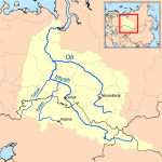
Ob-Irtysh River
THE OB AND THE IRTYSH rivers together form one of the largest river BASINs in the world, but also drain an area among the least populated and least known to outsiders. The rivers flow from the isolated mountain ranges of Central Asia (the ALTAI and Sayan ranges) across the sparsely populated Western Siberian Lowland to […]
Nubia
NUBIA, KNOWN AS THE Gateway to the SUDAN, does not exist as a political entity in the 21st century. Geographically, the section of Northeast Africa that was once Nubia has been encompassed into northern Sudan and southern EGYPT, with cataracts (areas where geological forces have formed outcroppings of rock) along the NILE RIVER determining Nubia's […]
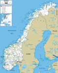
Norway
Area 125,182 square mi (324,220 square km) Population 5.136 million 2014 Capital Oslo Highest Point 8,148 ft (2,469 m) Lowest Point 0 m GDP $500.1 billion 2014 Primary Natural Resources petroleum, copper, natural gas, pyrites, nickel. NORWAY IS A LONG, narrow country, stretching from the North Sea to the ARCTIC OCEAN, roughly the same length […]
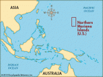
Northern Mariana Islands
A COMMONWEALTH IN political union with the UNITED STATES, the Northern Mariana Islands (or CNMI) consists of a string of fourteen volcanic and limestone islands in the far western PACIFIC OCEAN. The islands have closer ties to American and European culture than most others in the region and have therefore opted to retain political and […]
North Slope
THE NORTH SLOPE of ALASKA stretches from the high mountains of the Brooks Range to the ARCTIC OCEAN on the north. Miles of barren coastal plains and low, rolling hills, caused by freezing and thawing of the ground, make up the region. No trees are in evidence, as the short growing season will support only […]
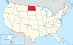
North Dakota
NORTH DAKOTA, THE Flickertail State, is a land of endless fields of corn, sunflowers, wheat, and buffalo. The state has a small population but is rich in natural resources. Located in the north central UNITED STATES, North Dakota was named after the Sioux Indians who called themselves the Dakota. Rural depopulation is a serious problem […]
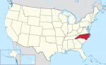
North Carolina
KNOWN AS BOTH the Tar Heel State and Old North State, North Carolina was part of colonial America. Like its sister state SOUTH CAROLINA, North Carolina was named for Kings Charles I and Charles II of England. North Carolina is bounded on the north by VIRGINIA, on the south by South Carolina and GEORGIA, on […]
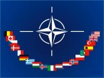
North Atlantic Treaty Organization
AT THE END OF World War II (1939–45), Europe lay in wasted ruin with most industrial and transportation infrastructure damaged or destroyed. Some 40 million deaths had occurred in Europe and RUSSIA in the six years of conflict. Approximately 25 million displaced persons were stranded far from original homelands with little resources. The UNITED STATES […]
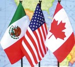
North American Free Trade Agreement
IN 1993, THE UNITED STATES, CANADA, and MEXICO signed the North American Free Trade Agreement (NAFTA), which created a regional free trade zone that lowered tariffs and trading restrictions and encouraged greater opportunities for cross-border investments and movement of goods and services between the three countries. The agreement went into effect in 1994. While all three […]
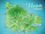
Norfolk Island
NORFOLK ISLAND, AN AUSTRALIAN territory, is located in the south PACIFIC OCEAN, 1,041 mi (1,676 km) northeast of Sydney, AUSTRALIA. With a total land area of 13 square mi (35 square km), the island is slightly larger than the District of Columbia; it is approximately 5 mi (8 km) in length and 3 mi (5 […]
Niue
Area 100 square mi (260 square km) Population 2,145 Capital Alofi Highest Point unnamed hill near the town of Mutalau 223 ft (68 m) Lowest Point 0 m GDP per capita $3,600 Primary Natural Resources agriculture. ONE OF THE WORLD'S largest coral islands and smallest countries, Niue is about the size of metropolitan District of […]
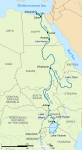
Nile River
AT 4,132 mi (6,650 km) long, the Nile River is the longest river in the world. It flows from two principal sources in equatorial Africa that join at KHARTOUM, SUDAN, and continues north through Sudan and EGYPT, emptying into the MEDITERRANEAN SEA. Historically, the Nile has been used in irrigation, farming, and transportation for thousands […]
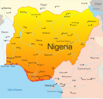
Nigeria
Area 356,667 square mi (923,768 square km) Population 177.5 million (2014) Capital Abuja Highest Point 7,936 ft (2,419 m) Lowest Point 0 m GDP $568.5 billion (2014) Primary Natural Resources oil, coal, tin, palm oil, peanuts, cotton, rubber. NIGERIA, THE MOST populous nation in Africa, is bordered to the south by the Gulf of Guinea […]
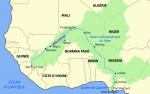
Niger River
LOCATED IN West Africa, the Niger River stretches 2,610 mi (4,200 km) in length, making it the thirdlongest river in Africa, after the NILE and the CONGO. It is ranked 14th among the longest rivers in the world. The drainage basin of the river encompasses 807,000 square mi (2,090,000 square km). The Niger River runs […]
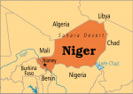
Niger
Area 489,191 square mi (1,267,000 square km) Population 19.11 million (2014) Capital Niamey Highest Point 6,634 ft (2,022 m) Lowest Point 656 ft (200 m) GDP $8.169 billion (2014) Primary Natural Resources uranium, coal, iron ore, tin. A LANDLOCKED republic in West Africa, Niger is bordered by ALGERIA to the northwest, MALI and BURKINA FASO […]
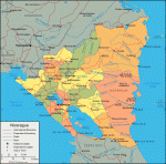
Nicaragua
Area 49,998 square mi (129,494 square km) Population 6.014 million 2014 Capital Managua Highest Point 7,998 ft (2,438 m) Lowest Point 0 m GDP $11.81 billion 2014 Primary Natural Resources gold, silver, cooper, tungsten, lead, zinc. BORDERED by COSTA RICA and HONDURAS, Nicaragua is the largest country in Central America. The country is divided into […]
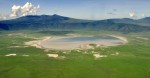
Ngorongoro Crater
LOCATED IN NORTHERN TANZANIA, 80 mi (129 km) west of the city of Arusha is the Ngorongoro Crater. This crater is a caldera formed by the collapse of a large volcano in the Great RIFT VALLEY. It is considered to be the largest subsidence crater in the world with a width of over 12.5 mi […]
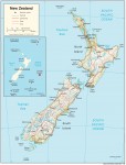
New Zealand
Area 107,737 square mi (268,680 square km) Population 4.510 million 2014 Capital Wellington Highest Point 12,283 ft (3,754 m) Lowest Point 0 m GDP $188.4 billion 2013 Primary Natural Resources natural gas, iron ore, sand, coal. IN THE SOUTH PACIFIC OCEAN, the country of New Zealand lies to the southeast of AUSTRALIA. However, while Australia […]

Newton, Isaac (1642–1727)
SIR ISAAC NEWTON WAS one of the most famous and influential men in the world of science, in both mathematics and natural philosophy. His laws of gravity and motion formed the basis of classical mechanics, principles that are at the heart of modern engineering, physics, and astronomy. His work provided a mathematical mechanism to prove […]
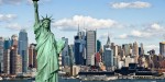
New York City
“THE BIG APPLE,” covering 303 square mi (785 square km), is located at the southernmost point of New York State. It is bounded to the north by Westchester County, to the east by Nassau County, and to the west by the state of NEW JERSEY, across the HUDSON RIVER. The city is comprised of five […]
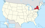
New York
NEW YORK—OFTEN called New York State to distinguish it from NEW YORK CITY—is a northeastern state of the UNITED STATES, bordering VERMONT, MASSACHUSETTS, and CONNECTICUT to the east; PENNSYLVANIA and NEW JERSEY to the south; and the Canadian provinces of Ontario and Quebec to the north. Lakes ERIE and ONTARIO form the greater part of […]
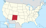
New Mexico
NEW MEXICO IS THE “Land of Enchantment.” Nowhere else in the UNITED STATES can such a variety of landscapes, histories, and traditions be found. Located in the American southwest, New Mexico is part of the dry and warm Four Corners region. Although primarily arid in the southern deserts to semi-arid in the high deserts, there […]
New Jersey
THE STATE OF New Jersey, located on the east coast of the UNITED STATES between NEW YORK, PENNSYLVANIA, and DELAWARE, is home to hundreds of flora and fauna. The landscape of the state is comprised of pine forests and flatlands in the interior, swampy meadowlands in the north and the dry Pinelands in central and […]
New Hampshire
LOCATED IN THE northeastern UNITED STATES, the state of New Hampshire has a total area of 9,304 square mi (23,380 square km) of land and 277 square mi (23,3380 square km) of inland water, with its geographic center lying in Belknap County, 3 mi (5 km) east of the town of Ashland. New Hampshire is […]
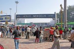
New Delhi
NEW DELHI, by current estimates, has a population of about 300,000 persons, although Greater Delhi's population is estimated to be between 12 and 14 million, making it the third-largest urban settlement in INDIA. Located at the western side of the Gangetic Plain in India, New Delhi is also located next to the city of Delhi, […]
New Caledonia
NEW CALEDONIA IS A French protectorate located in southwestern Oceania, approximately equidistant from AUSTRALIA, NEW ZEALAND, and FIJI. It consists of the principal island, Grande Terre, as well as the outlying Loyalty Islands and their nearby atolls and reefs. Archaeological evidence suggests human settlement dates from approximately 4000 B.C.E. Distinct forms of pottery and imported […]
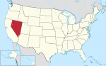
Nevada
KNOWN AS THE Silver State, the Battle-Born State, or the Sagebrush State, the mountain state of Nevada was admitted to the Union in 1864 as the 36th state. Covering an area of 110,540 square mi (286,297 square km), Nevada is 485 mi (780 km) north to south and 315 mi (507 km) east to west, […]
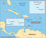
Netherlands Antilles
AN OVERSEAS TERRITORY of the NETHERLANDS, the Netherlands Antilles consists of four and a half islands, separated by about 545 mi (880 km) of the CARIBBEAN SEA. The southern group, Curacao and Bonaire, known as the Windward Islands, lie 40 to 50 mi (60 to 80 km) off the northern coast of VENEZUELA. Formerly known […]
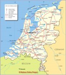
Netherlands
Area 16,033 square mi (41,526 square km) Population 16.85 million 2014 Capital Amsterdam Highest Point 1,063 ft (322 m) Lowest Point -23 ft (-7 m) GDP $869.5 billion 2014 Primary Natural Resources natural gas, petroleum, arable land. THERE IS A SAYING that God created the world, but the Dutch created Netherlands. Since roughly the 12th century, […]
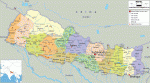
Nepal
Area 87,489 square mi (140,800 square km) Population 28.17 million 2014 Capital Katmandu Highest Point 29,035 ft (8,850 m) Lowest Point 230 ft (70 m) GDP $19.64 billion 2014 Primary Natural Resources quartz, water, timber. NEPAL, LOCATED between two Asian giants INDIA and CHINA, is a small country of approximately the size of the American state […]
Negev Desert
THE NEGEV IS A part of the Saharo-Arabian desert belt running from the ATLANTIC OCEAN across the SAHARA and Arabia to the Sind desert of INDIA's Indus Valley. The Negev, also spelled Negeb, means both “the southland” and “dry.” Negev is derived from the Hebrew verbal root n-g-v meaning “to dry.” The Ha-Negev (Hebrew) covers […]

needs and wants
WANTS AND NEEDS are concepts that have come to be developed around three different spheres of discussion, biological, social, and economic. Each is an expansion in size and scale over the one preceding it. In addition, it is important to remember that the subject is biological in character. This means that we do not discuss […]
Nebraska
KNOWN AS THE Cornhusker State, the west northcentral state of Nebraska was named from a Native American word meaning “flat or broad water.” It lies within the Missouri River basin; the western part of the state also lies within the Platte River basin. Nebraska covers an area of 77,354 square mi (200,346 square km), making […]
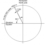
nautical mile
A UNIT OF DISTANCE used primarily at sea and in aviation, the nautical or sea mile is based on the average meter distance on the Earth's surface represented by one minute of latitude. Because it is based on the earth's dimensions, the nautical mile is extremely convenient to use for any type of navigation. Adopted […]
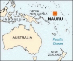
Nauru
Area 8 square mi (21 square km) Population 12,570 Capital None, government offices in Yaren District Highest Point 200 ft (61 m) Lowest Point 0 m GDP per capita $5,000 Primary Natural Resources phosphates, fish. NAURU, LOCATED near the equator south of the MARSHALL ISLANDS in the south PACIFIC OCEAN, is the world's smallest independent republic. […]
nationalism
THE MODERN CONCEPT of nationalism was born with the Treaty of Westphalia in 1648. Before then, Europe was a checkerboard of small states, cities, principalities, and alliances united by religions, language, history, and politics. As recently as the 1800s, such nations as CHINA, INDIA, and even ITALY looked nothing like they do today but instead […]
Nap of the Earth
NAP OF THE EARTH, or NOE, is a Vietnam War-era term for very low-level flight, particularly of helicopters. The concept behind this type of flying is that a pilot guides his or her craft as close to the Earth's surface as terrain, vegetation, and other obstructions will allow and maintains that low altitude while approaching […]
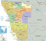
Namibia
Area 318,696 square mi (825,418 square km) Population 2.403 million (2014) Capital Windhoek Highest Point 8,550 ft (2,606 m) Lowest Point 0 m GDP $13.43 billion (2014) Primary Natural Resources diamonds, gold, tin, copper, lead, zinc. NAMIBIA, FORMERLY known as South West Africa (SWA), is located in southern Africa. It borders the South ATLANTIC OCEAN, […]
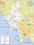
Myanmar (Burma)
Area 261,970 square mi (678,500 square km) Population 53.44 million 2014 Capital Rangoon Highest Point 9,692 ft (2,954 m) Lowest Point 0 m GDP $64.33 billion 2014 Primary Natural Resources petroleum, timber, tin, antimony, zinc, copper. A KITE-SHAPED country with a 1,243-mi (2,000-km) north-south stretch, Myanmar has its apex in the north, bordering INDIA and […]
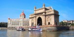
Mumbai (Bombay)
BOMBAY, RENAMED Mumbai in 1995, is a city in western INDIA and the capital of the Indian state of Maharashta. With its three totally computerized stock exchanges that handle 70 percent of the country's stock transactions and manufacturing (particularly in textiles, which employs 11 percent of India's factory workers), Mumbai is the most important economic center […]
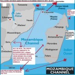
Mozambique Channel
LOCATED OFF the country of MOZAMBIQUE in Africa, the Mozambique Channel lies within the INDIAN OCEAN, between the African continent and the island of MADAGASCAR. The currents in the Mozambique Channel usually form an anticyclonic system but sometimes they do flow directly south into the Agulhas Current off the coast of SOUTH AFRICA. This area […]
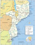
Mozambique
Area 309,496 square mi (801,590 square km) Population 27.22 million (2014) Capital Maputo Highest Point 7,992 ft (2,436 m) Lowest Point 0 m GDP $16.39 billion (2014) Primary Natural Resources coal, natural gas, titanium ore, iron ore. MOZAMBIQUE IS located in southeast Africa and is about twice the size of CALIFORNIA. It is bordered on […]
Mosquito Coast
THE MOSQUITO COAST, or Mosquitia, is located on the east coast of NICARAGUA and HONDURAS. The name is derived from the Miskito, the indigenous people of the region. The Miskito are descendants of the Chorotega, an aboriginal people of South America. Because of the absence of historic ruins, little is known of the Chorotega people, […]
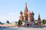
Moscow
MOSCOW IS THE capital city of the Russian Federation, and although superseded as the official capital during the 18th and 19th centuries, it has dominated Russian politics, culture, and economics since the 14th century. Today, it is RUSSIA's largest city and one of the largest urban centers in Europe. Geographically, Moscow lies at the center […]
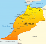
Morocco
Area 172,413 square mi (446,550 square km) Population 33.92 million (2014) Capital Rabat Highest Point 13,665 ft (4,165 m) Lowest Point -180 ft (-55 m) GDP $107.0 billion (2014) Primary Natural Resources agriculture, phosphate mining, minerals. MOROCCO REPRESENTS the finest example of multicultural fusion, combining 2,000 years of languages, rituals and customs, cuisine and foods, […]
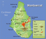
Montserrat
THE ISLAND OF Montserrat, an overseas territory of the UNITED KINGDOM, is part of the chain of islands in the CARIBBEAN SEA that were formed millions of years ago by volcanoes, some of which remain active, while others are completely dormant. Montserrat itself is composed of seven active volcanoes of varying ages, which have been […]
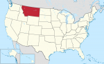
Montana
AS THE TREASURE STATE, Montana is known for its mountains and extensive natural resources, such as copper, silver, gold, coal, lead, zinc, oil, limestone, antimony, phosphates, and gypsum. This mountain state encompasses 147,046 square mi (380,821 square km) of land area; Montana is the fourth largest state in the UNITED STATES, but it is 44th […]
monsoon
THE HEAVY RAINS of the monsoon appear in June and subside in September every year in the Northern Hemisphere. Meteorologists and scientists are greatly helped by the development of sophisticated weather analysis and forecasting technology in understanding monsoon mechanisms. Numerous people on the earth are affected by this significant climatic system. The monsoon directly governs […]
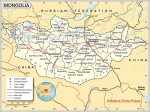
Mongolia
Area 604,250 square mi (1,565,000 square km) Population 2.910 million 2014 Capital Ulaanbaatar Highest Point 14,350 ft (4,374 m) Lowest Point 1,699 ft (518 m) GDP $12.02 billion 2014 Primary Natural Resources oil, coal, copper, tin, nickel. ONCE ONE OF THE world's largest empires (under Genghis Khan), Mongolia eventually became a territory of CHINA, then […]
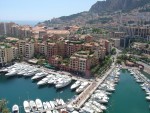
Monaco
Area .75 square mi (1.95 square km) Population 37,620 2014 Capital Monaco-Ville Highest Point Mount Agle 460 ft (140 m) Lowest Point 0 m GDP $6.075 billion 2011 Primary Natural Resources climate for tourism. WHILE EXTREMELY SMALL at only 48 acres (19.4 hectares) in area bordering FRANCE and ITALY, Monaco still has several distinct geographic […]