Benguela Current
THE BENGUELA CURRENT is one of the world's four major eastern boundary currents. It flows northward off the coast of southwestern Africa along the western coasts of SOUTH AFRICA, NAMIBIA, and southern ANGOLA. The Benguela Current, along with the South Equatorial Current, and the northern part of the Antarctic Circumpolar Current make up the South Atlantic subtropical gyre. The Benguela Current draws icy-cold waters from the Southern Ocean and carries them northward along the coast of Africa. Because of these cold waters, rain clouds do not develop over the southwest coast of Africa, contributing to the parched climate of the KALAHARI and Namib deserts.
The Benguela Current is one of those regions off the west coasts of the continents where there is an upwelling of cool, nutrient-rich water due to the coastal edge of the continental shelf, the prevailing winds, and the Earth's rotation. Because of these nutrient-rich waters, there is a huge abundance of marine life of all kinds. This has resulted in a large and plentiful fishing industry off Africa's southwest coast. In direct contrast to this, there are areas of the Benguela Current off the coast of Namibia and along the Walvis Ridge in which there are no fish to be found. This is due to a buildup of harmful algae blooms and high hydrogen sulfide gas levels in the water that are toxic to marine life. This phenomenon is known as “red tide” and is usually confined to localized inshore areas, such as off the west coast of FLORIDA. But because of changes in wind direction, it can occur offshore in the Benguela Current.
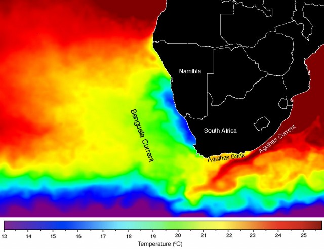
About 93 to 124 mi (150 to 200 km) off the coast of South Africa, the Benguela Current begins with an upwelling of ocean currents. It spans from this area around 35 degrees south northward to between 14 degrees and 17 degrees south, where it meets the Angolan Current. At this northern boundary, the change is more dramatic, with cold and warm water meeting to form a thermal front along the coast. The Benguela Current covers around 57,915 square mi (150,000 square km) when using the continental shelf as the offshore boundary line.
The continental shelf near the Benguela is from 40 to 80 mi (64 to 128 km) wide. From the shelf, the ocean bottom slopes steeply away into the abyssal depths of the Cape and Angola basins, each about 16,400 ft (5,000 m) deep. These BASINs are separated by the Walvis Ridge, which starts just off the coast at about 20 degrees south and stretches to the west, linking up with the central Atlantic Ridge. The Walvis Ridge rises to above 2,460 ft (750 m) in many places along its track. This area is exposed to persistent alongshore winds associated with a high-pressure weather system.
The surface temperatures of the Benguela Current are about 14 degrees F (8 degrees C) colder than average for coastlines in these latitudes. The coldest waters of the current run right along the coast of Africa, with very little seasonal variation except in the extreme south near Cape Town, South Africa, where the water is colder in the summer than it is in the winter. Surface temperatures average about 50 to 59 degrees F (10 to 15 degrees C) near the coast and reach up to 77 degrees F (25 degrees C) on the surface, out along the continental shelf.