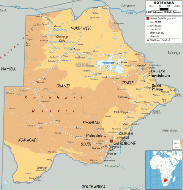
Botswana
Area 231,803 square mi (600,370 square km)
Population 2.039 million (2014)
Capital Gaborone
Highest Point 4,890 ft (1,491 m)
Lowest Point 1,682 ft (513 m)
GDP $15.81 billion (2014)
Primary Natural Resources diamonds, copper, silver.
BOTSWANA IS a LANDLOCKED country in southern Africa, approximately 310 mi (500 km) from the nearest coastline to the southwest. Although two-thirds of Botswana is within the tropics, the landscape is dominated by the KALAHARI DESERT (after the Setswana name Kgalagadi), a sand-filled BASIN averaging 3,607 ft (1,100 m) above sea level.
Botswana is bordered by ZAMBIA and ZIMBABWE to the northeast, NAMIBIA to the north and west, and SOUTH AFRICA to the south and southeast. At Kazungula, four countries—Botswana, Zimbabwe, Zambia and Namibia—meet at a single point midstream in the Zambezi River in the extreme northeast. If it were not for an interesting strip of land in the north, the Caprivi Strip, Botswana might also have a border with ANGOLA. The Caprivi is a narrow strip of land in the far northeast of Namibia that is about 250 mi (400 km) long and forms the Namibian part of the border with Botswana. Germany exchanged the area (together with Helgoland) with the UNITED KINGDOM for Zanzibar in 1890. It was named after the German chancellor of the time, Graf von Caprivi, who signed the contract with the British.

BOTSWANA RIVERS
The Chobe River runs along part of Botswana’s northern boundary; the Nossob River at the southwestern boundary; the Molopo River along the southern boundary; and the Marico, Limpopo and Shashe rivers at its eastern boundaries. Like the Okavango and Zambezi rivers, the Chobe’s course is affected by fault lines, which are extensions of East Africa‘s Great Rift Valley. Taken together, these three rivers carry more water than all other rivers in southern Africa combined. Except for the Okavango and Chobe areas in the north, the country has little permanent surface water.
The eastern hardveld (hard-surfaced grazing area), where 80 percent of the country’s population lives and where its three largest urban centers are situated, is a wide strip of land running from the north at Ramokgwebane to the south at Ramatlabama. It has a more varied relief and geology with inselbergs (outcrops of resistant rock) and koppies (rocks that have been weathered into blocks) dotting the landscape. The southeastern hardveld has a slightly higher and more reliable rainfall than the rest of the country, and the natural fertility and agricultural potential of the soils, while still low, are greater than in the Kalahari sandveld (sand-surfaced grazing area).
THE KALAHARI
The Kalahari Desert stretches west of the eastern hardveld, covering 84 percent of the country. The word desert, however, is a misnomer. Most of the Kalahari is covered with vegetation, including stunted thorn and scrub bush, trees and grasslands. The largely unchanging flat terrain is occasionally interrupted by gently descending valleys, sand dunes, isolated hills in the extreme northwest, and large numbers of pans that fill with water during the rainy season. These pans are of great importance to wildlife, which obtain valuable nutrients from the salts and the grasses of the pans.
In the northwest, the Okavango River flows in from the highlands of Angola and soaks into the sands, forming a 5,791 square mi (15,000 square km) network of water channels, lagoons, swamps and islands. The Okavango is the largest inland DELTA system in the world, just slightly smaller than ISRAEL in size.
Although Botswana has no mountain ranges to speak of, the landscape is occasionally punctuated by low hills, especially along the southeastern boundary and in the far northwest.
HISTORY
Formerly the British protectorate of Bechuanaland, Botswana adopted its new name upon independence in 1966. San (Bushmen) were the aboriginal inhabitants of what is now Botswana. Beginning in the 1820s, the region was part of the expansion of the Zulu and their offshoot, the Ndebele.
In the late 19th century, Boers (Afrikaners) from neighboring Transvaal spread into the region as gold was discovered. With the Boers continuing to encroach on native lands during the 1870s and 1880s and German colonial expansion pressing into South-West Africa (Namibia), the British were forced to reexamine their policies and established Bechuanaland as a protectorate in 1885. The southern part of the area was incorporated into Cape Colony in 1895, where a resident commissioner administered it until 1961. Although Bechuanaland had no nationalist movement, Britain granted it internal self-government in 1965 and full independence as Botswana on September 30, 1966.
Agriculture still provides a livelihood for more than 80 percent of the population but supplies only about 50 percent of food needs and accounts for only 3 percent of the country’s gross domestic product (GDP). The country’s water shortage and lack of sufficient irrigation facilities has severely hampered agriculture development, and only a small percentage of the land is under cultivation. Where there is sufficient water, corn, sorghum, millet, and beans are the principal subsistence crops, and cotton, peanuts, and sunflowers are the main cash crops. Cattle raising and mining dominate the economy.
At the time of independence, the only known minerals were manganese and some gold and asbestos. Since that time, large deposits of nickel and copper have been found, as well as salt and soda ash. Vast coal deposits are also being worked, and antimony and sulfur are known to exist. Botswana’s three diamond mines collectively make up one of the largest diamond reserves in the world. The stones are mined by the government and a South African mining concern, providing a strong link between Botswana’s well-being and South Africa. Deposits of plutonium and platinum are also know to exist, but are as yet undeveloped.
Although Botswana’s mineral wealth has made it one of the wealthiest nations of southern Africa, high unemployment remains a problem. Development of the tourist industry has been growing, based partly on the country’s game reserves. Because of its landlocked position, Botswana remains heavily dependent on South Africa for the provision of port facilities.