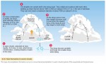
Types of Precipitation
Precipitation consists of liquid water drops and solid crystals that fall from the atmosphere and reach the ground. This precipitation can take several different forms. RAIN Rain is precipitation that reaches the ground as liquid water. Raindrops can form in warm clouds as liquid water, which through collisions can coalesce with other drops and grow large enough to fall to Earth. […]
Precipitation
FORMATION OF PRECIPITATION Clouds are the source of precipitation—the process that provides the fresh water essential for most forms of terrestrial life. Precipitation can form in two ways. In warm clouds, fine water droplets condense, collide, and coalesce into larger and larger droplets that can fall as rain. In colder clouds, ice crystals form and grow in a cloud that contains a mixture of […]
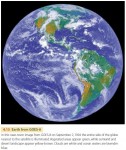
Observing Clouds from GOES
Some of the most familiar images of Earth acquired by satellite instruments are those of the Geostationary Operational Environmental Satellite (GOES) system. Images from the GOES series of satellites have been in constant use since 1974. The primary mission of the GOES series is to view cloud patterns and track weather systems by providing frequent images of the Earth from a consistent viewpoint in space provided by […]

Clouds
Clouds are frequent features of the atmosphere. Views of the Earth from space show that clouds cover about half of the Earth at any given time. Low clouds reflect solar energy, thus cooling the Earth–atmosphere system, while high clouds absorb outgoing longwave radiation, thus warming the Earth– atmosphere system. One of the most familiar roles of clouds, however, is in producing precipitation. Clouds […]
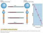
The Adiabatic Process
What makes the water vapor in the air turn into liquid or solid particles that can fall to the Earth? The answer is that the air is naturally cooled. When air cools to the dew point, the air is saturated with water. Think about extracting water from a moist sponge. To release the water, you have to squeeze the sponge—that […]
Humidity
Blistering summer heat waves can be deadly, with the elderly and the ill at most risk. However, even healthy young people need to be careful, especially in hot, humid weather. High humidity slows the evaporation of perspiration from our bodies, reducing its cooling effect. Clearly, it is not only the temperature of the air that controls how hot weather affects us—the amount of water vapor in […]
Water in the Environment
In this chapter, we focus on water in the air, both as vapor and as liquid and solid water. Precipitation is the fall of liquid or solid water from the atmosphere that reaches the Earth's land or ocean surface. It forms when moist air is cooled, causing water vapor to form liquid droplets or solid ice particles. If cooling is […]
Acid Deposition
Perhaps you've heard about acid rain killing fish and poisoning trees. Acid rain is part of the phenomenon of acid deposition. It's made up of raindrops that have been acidified by air pollutants. Fossil fuel burning releases sulfur dioxide (SO2) and nitric oxide (NO2) into the air. The SO2 and NO2 readily combine with oxygen and water in the presence of […]
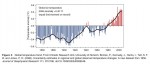
Global Warming and the Greenhouse Effect
The Earth is getting warmer. In February 2007, the Intergovernmental Panel on Climate Change (IPCC), a United Nations-sponsored group of more than 2000 scientists, issued a report saying that global warming is “unequivocal”. Is this recent warming an effect of human activity? In 1995 the IPCC concluded that human activity has probably caused climatic warming by increasing the concentration of greenhouse gases […]
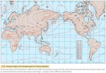
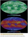
World Patterns of Air Temperature
We have learned some important principles about air temperatures in this chapter. Surface type (urban or rural), elevation, latitude, daily and annual insolation cycles, and location (maritime or continental) can all influence air temperatures. Now let's put all these together and see how they affect world air temperature patterns. First, we need a quick explanation of air temperature maps. Figure 3.21 shows a set of isotherms—lines connecting locations […]
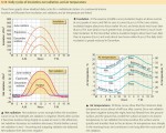
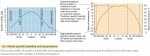
Daily and Annual Cycles of Air Temperature
Let's turn to how, and why, air temperatures vary around the world. Insolation from the Sun varies across the globe, depending on latitude and season. Net radiation at a given place is positive during the day, as the surface gains heat from the Sun's rays. At night, the flow of incoming shortwave radiation stops, but the Earth continues to radiate longwave […]
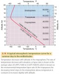
Temperature Structure of the Atmosphere
In general, the air is cooler at higher altitudes. Remember from Chapter 2 that most incoming solar radiation passes through the atmosphere and is absorbed by the Earth's surface. The atmosphere is then warmed at the surface by latent and sensible heat flows. So it makes sense that, in general, air farther from the Earth's surface will be cooler. We call […]
Surface and Air Temperature
This chapter focuses on air temperature—that is, the temperature of the air as observed at 1.2 m (4 ft) above the ground surface. Air temperature conditions many aspects of human life, from the clothing we wear to the fuel costs we pay. Air temperature and air temperature cycles also act to select the plants and animals that make up the biological landscape of a region. […]
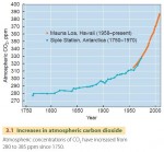
Carbon Dioxide — On the Increase
One of the most important factors affecting air temperatures over the long run is the greenhouse effect, in which atmospheric gases absorb outgoing longwave radiation and reradiate a portion back to the surface. This makes surface temperatures warmer. Apart from water vapor, carbon dioxide gas plays the largest role in the greenhouse effect and CO2 concentration is increasing. In the centuries before […]
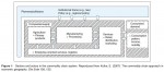
CERES—Clouds and the Earth’s Radiant Energy System
The Earth's global radiation balance is the primary determinant of long-term surface temperature, which is of great importance to life on Earth. Because this balance can be affected by human activities, such as converting forests to pasturelands or releasing greenhouse gases into the atmosphere, it is important to monitor the Earth's radiation budget over time as accurately as possible. For nearly 20 years, NASA has studied the […]
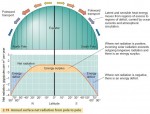
Net Radiation, Latitude, and the Energy Balance
Although the energy budgets of the Earth's surface and atmosphere are in balance overall, their budgets do not have to balance at each particular place on the Earth, nor do they have to balance at all times. At night, for example, there is no incoming radiation from the Sun, yet the Earth's surface and atmosphere still emit out going radiation. Net […]
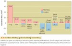
The Global Energy System
Human activity around the globe has changed the planet's surface cover and added carbon dioxide to the atmosphere. Have we irrevocably shifted the balance of energy flows? Is our Earth absorbing more solar energy and becoming warmer? Or is it absorbing less and becoming cooler? If we want to understand human impact on the Earth–atmosphere system, then we need to examine the […]
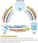
Sensible Heat and Latent Heat Transfer
The most familiar form of heat storage and transport is known as sensible heat—it's what you feel when you touch a warm object. When we use a thermometer, we are measuring sensible heat. Sensible heat transfer moves heat from warmer to colder objects by conduction when they are in direct contact. Sensible heat is also transferred by convection when a fluid such as the atmosphere […]
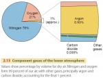
Composition of the Atmosphere
The Earth is surrounded by air—a mixture of various gases that reaches up to a height of many kilometers. This envelope of air makes up our atmosphere (Figure 2.13). It is held in place by the Earth's gravity. Almost all the atmosphere (97 percent) lies within 30 km (19 mi) of the Earth's surface. The upper limit of the atmosphere is […]
Insolation over the Globe
Most natural phenomena on the Earth's surface—from the downhill flow of a river to the movement of a sand dune to the growth of a forest—are powered by the Sun, either directly or indirectly. It is the power source for wind, waves, weather, rivers, and ocean currents, as we will see here and in later chapters. Although the flow of solar […]

Electromagnetic Radiation
All surfaces—from the fiery Sun in the sky to the skin covering our bodies—constantly emit radiation. Very hot objects, such as the Sun or a light bulb filament, give off radiation that is nearly all in the form of light. Most of this energy is visible light, which we perceive with the colors of the rainbow, but the Sun also […]
The Ozone Layer— Shield to Life
High above the Earth's surface lies an atmospheric layer rich in ozone—a form of oxygen in which three oxygen atoms are bonded together (O3). Ozone is a highly reactive gas that can be toxic to life and damaging to materials, but high in the atmosphere it serves an essential purpose—sheltering life on the Earth's surface from powerful ultraviolet radiation emitted by […]
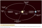
The Earth’s Revolution around the Sun
So far, we have discussed the importance of the Earth's rotation on its axis. But what about the Earth's movement as it orbits the Sun? We refer to this motion as the Earth's revolution around the Sun. The Earth takes 365.242 days to travel around the Sun—almost a quarter of a day longer than the calendar year of 365 days. […]
Global Time
There's an old Canadian joke that goes, “Repent! The world will end at midnight! or 12:30 A.M. in Newfoundland.” It's humorous because independent-minded Newfoundlers use a time zone that is a half-hour ahead of the other Canadian maritime provinces. It highlights the fact that one single instant across the world—no matter how cataclysmic—is simultaneously labeled by different times in different local places. […]
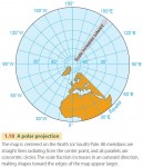
Map Projections
The problem of how to best display the Earth's surface has puzzled cartographers, or mapmakers, throughout history. The oldest maps were limited by a lack of knowledge of the world, rather than by difficulties caused by the Earth's curvature. They tended to represent political or religious views rather than geographic reality. Ancient Greek maps from the sixth century B.C. show the world […]
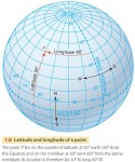
The Geographic Grid
It is impossible to lay a flat sheet of paper over a sphere without creasing, folding, or cutting it—as you know if you have tried to gift-wrap a ball. This simple fact has caused mapmakers problems for centuries. Because the Earth's surface is curved, we cannot divide it into a rectangular grid anymore than we could smoothly wrap a globe in […]
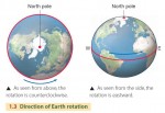
Earth Rotation
The Earth spins slowly on its axis —an imaginary straight line through its center and poles—a motion we refer to as rotation. We define a solar day by one complete rotation, and for centuries we have chosen to divide the solar day into exactly 24 hours. The North and South Poles are defined as the two points on the Earth's […]
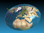
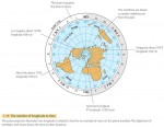
The Shape of the Earth
As we all learn early in school, the Earth's shape is very close to a sphere. Pictures taken from space by astronauts and by orbiting satellites also show us that the Earth is a ball rotating in space. Today it seems almost nonsensical that many of our ancestors thought the world was flat. But to ancient sailors voyaging across the […]
Earth Visualization Tools
Within the last few years, remote sensing, geographic information systems, and GPS technology have been integrated into new and exciting Internet tools for visualizing the Earth. Google Earth and World Wind are outstanding examples of these Earth visualization tools. GOOGLE EARTH Google Earth is a program for personal computers that allows users to roam the Earth's surface at will and zoom […]
Remote Sensing for Physical Geography
Another important geographic technique for acquiring spatial information is remote sensing. This term refers to gathering information from great distances and over broad areas, usually through instruments mounted on aircraft or orbiting spacecraft. These instruments, or remote sensors, measure electromagnetic radiation coming from the Earth's surface and atmosphere as received at the aircraft or spacecraft platform. The data acquired by remote sensors are […]
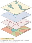
Geographic Information Systems
Maps, like books, are very useful devices for storing information, but they have limitations. Recent advances in computing capability have enabled geographers to develop a powerful new tool to work with spatial data—the geographic information system (GIS). A GIS is a computer-based system for acquiring, processing, storing, querying, creating, analyzing, and displaying spatial data. Geographic information systems have allowed geographers, geologists, geophysicists, ecologists, planners, […]
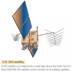
The Global Positioning System
The latitude and longitude coordinates of a point on the Earth's surface describe its position exactly. But how are those coordinates determined? For the last few hundred years, we have known how to use the position of the stars in the sky coupled with an accurate clock to determine the latitude and longitude of any point. Linked with advances in mapping […]
Maps and Cartography
Cartography is the field of geography concerned with making maps. A map is a paper representation of space showing point, line, or area data—that is, locations, connections, and regions. It typically displays a set of characteristics or features of the Earth's surface that are positioned on the map in much the same way that they occur on the surface. The map's […]
Tools in Physical Geography
Geographers use a number of specialized tools to examine, explore, and interact with spatial data. One of the oldest tools is the map—a paper representation of space showing where things are. While maps will never go out of style, computers have enhanced our ability to store, retrieve, and analyze spatial data through the development of geographic information systems (GIS). Acquiring geographic information […]
Physical Geography, Environment, and Global Change
Physical geography is concerned with the natural world around us—in short, with the human environment. Because natural processes are constantly active, the Earth's environments are constantly changing. Sometimes the changes are slow and subtle, as when crustal plates move over geologic time to create continents and ocean basins. At other times, the changes are rapid, as when hurricane winds flatten vast areas […]
Spheres, Systems, and Cycles
As a part of your introduction to physical geography, it will be useful to take a look at the big picture and examine some ideas that arch over all of physical geography—that is, spheres, systems, and cycles. The first of these ideas is that of the four great physical realms, or spheres of Earth—atmosphere, lithosphere, hydrosphere, and biosphere. These realms […]
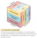
Introducing Geography
What is geography? Put simply, geography is the study of the evolving character and organization of the Earth’s surface. It is about how, why, and where human and natural activities occur and how these activities are interconnected. What makes geography different from other disciplines? Geography adopts a unique set of perspectives to analyze the world and its human and natural phenomena. These […]

Southern Africa, History
The arrival of Europeans in southern Africa in the 1600s set in motion a long period of upheaval that transformed the region. A series of violent conflicts pitted Dutch settlers against indigenous peoples, the Dutch against the British, the British against indigenous peoples, and various African groups against each other. After white settlers discovered gold and diamonds in the 1800s, […]
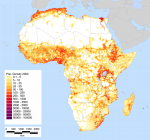
Population
Africa's population is growing at a faster rate than that of any other region of the world. According to the International Data Base of the U.S. Bureau of the Census, the estimated population of the continent in 2001 was 823.2 million people. The same organization projects that by the year 2050 Africa will have 1.8 billion people—perhaps 20 percent of […]
Popular Culture
Popular culture includes all forms of social and personal expression that are widely available and highly visible. Related to the world of ordinary middle-class, working-class, and poor people, this “mass culture” differs significantly from the more formal “high” culture of privileged and well-educated people. Often mass produced and current, popular culture includes forms of music, theater, and the other […]
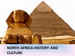
North Africa: History and Cultures
Separated from the rest of Africa by the SAHARA DESERT, the peoples of North Africa share a language and many cultural, political, and economic traditions. The term North Africa refers to the modern states of EGYPT, LIBYA, TUNISIA, ALGERIA, and MOROCCO, as well as the territory of WESTERN SAHARA. In ancient times the lands north of the Sahara and […]
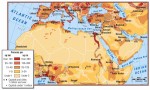
North Africa: Geography and Population
North Africa consists of five countries that border the Mediterranean Sea—EGYPT, LIBYA, TUNISIA, ALGERIA, and MOROCCO. The SAHARA DESERT, the dominant feature of the North African landscape, sweeps across the southern part of the region. The Sahara serves as a geographical boundary between North Africa and sub-Saharan Africa, except in Egypt. It also marks a transition zone from the largely […]
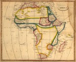
History of Africa
Tracing the history of Africa has presented a challenge to historians because of the lack of written records for much of the continent's past. Until recently most information had come from reports of foreign visitors, traders, and invaders over the last several hundred years. Historians of Asia and Europe, by contrast, have been able to use ancient records to construct […]
Government and Political Systems
The political systems of most African nations are based on forms of government put in place by colonial authorities during the era of European rule. Because these governmental institutions reject the indigenous political systems on which African society was built, they have generally failed to bring political stability. Many local and regional governments borrow from indigenous systems, but national political structures […]
Global Politics and Africa
Global politics, or geopolitics, refers to the relationships and interactions among nations as they compete for power, influence, and economic resources. Since the 1600s the global politics of Africa have been marked by dependence on others. To a large extent, Africans have been under the control of outsiders from the time of the transatlantic SLAVE TRADE, to European colonial rule, […]
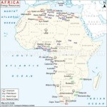
Energy and Energy Resources
Africa's resources include an abundant supply of petroleum, natural gas, and wood for fuel. The continent also has numerous rivers and waterfalls that could provide hydroelectric power. But Africans rely mostly on wood for energy. Most of the continent's other resources are expensive, available only in small quantities, and in limited areas. For a number of reasons, the development of […]
Economic History
Alack of written sources makes it difficult to trace the early economic history of much of the African continent, especially sub-Saharan Africa. What is clear is that Africans in precolonial times had basic economic activities that provided them with the things they needed to survive. At the same time, however, many factors limited the kind of intensive economic development […]
Development, Economic and Social
In general, development refers to a process by which countries use their natural and human resources to improve the economy and the lives of their people. Many experts also study development in terms of its outcome—the results that are achieved through economic, political, and social programs. A complex concept, development includes economic measures such as income and economic production, political measures […]
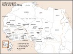
Archaeology and Prehistory
Africa's archaeological heritage is both ancient and rich. Several million years ago, the first ancestors of humans emerged in Africa. About 100,000 years ago, the first modern people appeared there as well. Since that time, a pageant has unfolded across the continent's vast and varied landscapes. Multitudes of cultures have emerged, peoples have migrated, empires have risen and fallen, and […]
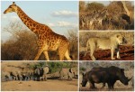
Animals, Domestic
Africans have been raising animals for their own use for thousands of years. Species of domesticated animals spread slowly southward through Africa, beginning around 3000 B.C. or earlier, and livestock herding became a traditional way of life across broad regions of the continent. Cattle, in particular, have played a central role in the social, economic, and religious lives of many […]
Competitiveness
Introduction Although rarely confronted directly, competitiveness is a central concept in economic geography. In location and regional development theories, and in their work on industrial restructuring, uneven development, industrial district formation, learning regions, and neoliberalization, economic geographers have asked what gives particular advantages to enterprises located in particular places. Far from unified in their approaches to this question, different authors have […]
Community
Community is one of those concepts about which social and cultural geographers worry. It is a difficult term to tie down, and it is used in a myriad of ways by all spectrums of society. In his influential Keywords, Raymond Williams points out that unlike other terms for social relations, such as state and nation, and even society, the term 'community' […]
Communist and Post-Communist Geographies
Efforts in geography to address the issues of socialism/communism failed to be seminal to the emergence of any powerful theory that could have been the result of putting the perspective of scientific communism on geography. It was the political economic approach of Marxism that imbued the geographies of state socialist countries the profoundly. Human geography was replaced with economic geography. […]
Communicable Diseases, Globalization of
Introduction Communicable diseases are the greatest disease threat facing humankind. Diseases previously considered eradicated are re emerging and new viruses are emerging. Due to increased human population and accelerated global travel, local outbreaks become instant global threats. Despite technological advances in medicine, devastating communicable diseases such as Ebola, severe acute respiratory syndrome (SARS) or avian influenza continue to surface and ravage humankind. […]
Commodity Chains
Commodity Chains: An Introduction The production of any commodity, whether it be a manufactured product or a service, involves an intricate articulation of individual activities and transactions across space and time. Such production networks – the nexus of interconnected functions and operations through which goods and services are produced and distributed – have become not only organizationally more complex but also increasingly […]
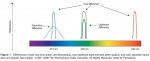
Color, Mapping
Introduction The word color is often associated with sensations that are named, such as red, blue, purple, and brown. However, the phenomenon of color is actually multidimensional. Color can be differentiated along three different dimensions: hue, lightness, and saturation. Color hue is related to the wavelengths of light that are perceived by the map reader, and is typically described […]
Colonialism, Internal
Definition Internal colonialism refers to a complex set of sociospatial relationships of exploitation and domination that characterize certain culturally distinct populations residing in sovereign, mainly ThirdWorld, societies. The two defining relationships of internal colonialism are that subjected populations are (1) exploited principally by mechanisms which may not be 'capitalist proper' and (2) institutionally dominated, both politically and culturally. In the first […]
Colonialism II
New Imperialisms, New Colonialisms, and New Political Geographies The later decades of the nineteenth century and the first years of the twentieth century witnessed European colonialism accelerate in pace and expand in scale. By 1914, much of the world was shaped by this process and its attendant, entwined webs of trade, migrants, political power, and knowledge. Historians usually trace this […]
Colonialism I
Introduction In recent years, there has been an enormous body of work which tries to understand modern European colonialism in all of its economic, social, and cultural dimensions, and to grapple with its legacies. The focus of this article is especially on British and, to a lesser extent, on French colonialism up to about 1870. The terms 'colonialism' and 'imperialism' […]
Cold War
The Cold War was named in 1947 by Bernard Baruch in his advisory role to President Truman as the United States, Great Britain, France, and its other Western allies faced off against the Soviet Union, with mutually aggressive maneuvers and countermoves, especially in Europe. This label was publicized more broadly by Walter Lippmann in a 1947 book with same name, […]

Cohen, S.
Cohen, Saul (1925–) Born in Malden, Massachusetts, and was educated in Boston, Saul Cohen graduated in geography of Harvard (MA 1948, PhD 1954) and served in Europe in World War II. A liberal Democrat, he is married to Miriam, has two daughters and seven grandchildren. In 50 prolific years of writing, teaching, and studying in geography, Saul Bernard Cohen has […]
Cognitive Geography
What Is Cognitive Geography? Cognitive geography is the study of cognition, primarily human cognition, about space, place, and environment. Cognition is knowledge and knowing by sentient entities, including humans, nonhuman animals, and artificially intelligent machines. Cognitive structures and processes include those of sensation, perception, thinking, learning, memory, attention, imagination, conceptualization, language, and reasoning and problem solving. Some of these structures and processes […]
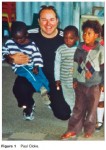
Cloke, P.
Cloke, Paul (1956 –) Professor of Human Geography at the University of Exeter, England, having previously worked in geography departments at Lampeter, Wales, and Bristol, England; by the early 1990s Martin Bodman identified Paul Cloke as an emerging 'master weaver' in human geography, a phrase used to characterize people having a significant influence within the discipline. Bodman argued that Cloke was one […]
Climate Change
Introduction Communities which cope with climatic hazards by im plicitly assuming a continuance of the status quo learn harsh lessons. Despite this, quite limited adaptation to known risks is often apparent in contemporary society. In the past, the catastrophe of harvest failure led to sometimes quite sophisticated coping responses and the shunning of areas of known high risk based on […]

Claval, P.
Claval, Paul (1932–) Paul Claval, born in Paris in 1932, is one of the most important geographers of his generation, both in terms of the extensive nature of his work and his originality, eclecticism, and international influence. His passion for geography developed during his teenage years in south-western France. While accompanying his father on summer work trips, Claval very quickly […]
Civil Society
Introduction Civil society is a contested term that broadly describes the arena of collective social interaction situated between the state, market, and household. Despite being used in a normative manner to encompass a host of values linked with participation and cooperation, it is more commonly used to describe a range of formal and informal nonstate organizations, groups, and associations that form […]
City-Region
Origin of the City-Region Since the 1990s, there has been a remarkable resurgence of the concept of the city-region in both academic and policy communities. In broad terms, the concept articulates the relationships between the city and its environs. For almost 30 years the focus on the city-region had been overshadowed by a shift of emphasis toward urban and particularly […]
City Marketing
Introduction Classic city slogans like ''I ? New York'' and ''Glasgow's Miles Better'' are so embedded in the popular consciousness as to have long outlasted their official use by their respective municipalities, chambers of commerce, and convention and visitors bureaus. Cities and towns are increasingly associated with symbols, slogans, or taglines (''What Happens Here Stays Here. Las Vegas'' or ''Johannesburg. A […]
Citizenship and Governmentality, Rural
Introduction In its most straightforward sense, citizenship is understood as bestowing upon individuals a legal status as members of a national polity, enacted by state apparatus and defended by legal and administrative rule and regulations. As members of that polity, individuals are entitled to certain political, civic, economic, and social rights, including individual freedom of speech, rights to property, the right […]
Citizenship
Introduction Citizenship refers to particular ways of being situated within and responding to relations of power through which a community is governed or ruled. It involves claiming, exercising, and contesting rights, entitlements, and obligations (e.g., rights to vote and strike, the obligation to pay taxes) and diverse ways of engaging with the institutions (such as the state) and relations through which […]
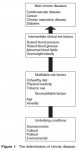
Chronic Disease
Introduction Chronic diseases are ongoing/recurring, not caused by infection, or passed on by contact. They generally cannot be prevented by vaccines, do not resolve spontaneously, and are rarely cured by medication or other medical procedures. Chronic diseases are often caused by a combination of health damaging behaviors (smoking, drinking, high fat diet, and physical inactivity) and exposure to socioenvironmental conditions (stressful […]
Christian Geography
Introduction Many a different adjective and prepositional phrase added to the word 'geography' has become common currency to identify and parcel out geography's distinctive fields, topics, regions, paradigms, approaches, research groups, national traditions, and historical periods. Christian is almost never one of them. There is Berkeley geography, Classical geography, the geography of aging, Japanese geography, idealist geography, the geography of the […]
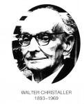
Christaller, W.
Walter Christaller (Figure 1), a German geographer and one of the founding fathers of the 'central place theory', was born on 21 April 1893 in Berneck in the Black Forest, and died on 9 March 1969 in Ko?nigstein in Taunus (Hesse), at the age of 75. His mother belonged to a cultured middle class family of Darmstadt and in her mature […]
Choice Modeling
Introduction A conventional premise of microeconomic theory is that demand and supply are traded off through continuous adjustments in quantities. Individual demand is determined by calculus methods that maximize consumer utility (i.e., satisfaction), subject to constraints. By the 1970s, it had become clear from the pioneering work undertaken in transportation, marketing, and economics that many consumer decisions do not conform to […]
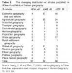
Chinese-Language Geography
A Long History of Chinese Human Geography Recognition of Human–Land Relation during the Formative Stage Human geography started to flourish in China more than 2500 years ago. The concept of 'geography' was first coined in the classic text of Yi Jing (or I Ching, Book of Changes), referring to the observation and understanding of the Earth's surface for the pursuance of […]
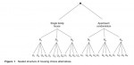
The Persistence of the State in Chinese Urbanism
It is clear that Chinese urbanism has evolved differently under different historical contexts. It has always contributed to state formation while reflecting the national concerns of the period in question. What sets Chinese urbanism apart from the urbanisms elsewhere is the persistently strong role of the state in shaping its character that began with China's first cities in the […]
Multiplex Urbanism in the Reform Era
China's dramatic urban transformation since the 1978 reforms is a consequence of the interplay between exogenous and endogenous forces at global, national, and local scales. As elsewhere, globalization and neoliberalism have strongly impacted the Chinese economy, but major endogenous policy shifts have been more important in effecting changes in the Chinese city, including the initiation of the policies of […]
Socialist Urbanism (1949–1978)
Socialist urbanism in China was created very quickly during the first three decades of Communist rule. From 1949 to 1978, cities served two major functions. First, they continued to serve as centers of national and local administration, a function that directly affected their growth. Second, cities played a passive supporting role in China's centrally planned socialist industrialization, serving essentially as spatial containers […]
The Arrival of the West and Modernist Urbanism (1840–1949)
Urbanism in China experienced a dramatic change in the mid nineteenth-century when increasing numbers of Western traders arrived in China demanding expanded trade along the China coast, which precipitated the Opium War (1839–1842) between the British and Chinese empires. China's loss of the Opium War and other subsequent wars with foreign powers resulted in a series of unequal treaties that forced […]
Administrative and Commercial Urbanism (770 BC–AD 1840)
Childe's key criteria defining early cities in the Old World show clearly the importance of economic production and trade in the rise of its early cities, and economic factors have remained dominant in subsequent Western urban history. In China, during the Zhou period (c. 1122–256 BC), a politically fragmentary era with many independent states contending for territory and superiority, […]
Neolithic Settlements and Incipient Urbanism (c. 5000–770 BC)
As in other parts of the world, early Chinese towns evolved from villages. During the Middle Neolithic era (c. 6500–5000 BC), large sedentary villages with a few hundred people based mainly on agriculture and animal domestication had emerged. Widely distributed in China, many of the villages were surrounded by circular ditches and walls constructed with the hangtu (tamped earth) technique, whereby layers […]
Chinese Urbanism
Cities are complex spatial entities consisting of economic, social, political, and cultural dimensions that differ significantly in different cultures, where they tend to undergo varying patterns of transformation over time. Cities and states are dynamically related and mutually constituted, with the former often embodying the essence of the latter. This is especially true in the case of China. Relative to other […]
Critiques and Challenges
Outside of academia, the children's rights movement has, as yet, had only limited success. The global position of children remains poor, with significant numbers of children lacking a basic education, clean water, or food. The UN Convention has been criticized for trying to impose a global vision of childhood which fails to adequately recognize cultural differences or varying needs. Moreover […]
Children’s Experiences of Place
The following section will explore one of the key contributions geographers are making to the study of childhood, by focusing on the empirical work geographers are doing in the everyday spaces of childhood which shape (and are shaped by) their lives. The Home The home is an important site for the negotiation of child–adult power relations. The home […]
The Spatial Construction of Childhood
One of the most important ways in which human geography can enhance our understanding of childhood is to highlight the importance of space and place to children's lives. Geographers question essentialist notions of a universal child by illustrating through diverse empirical studies the ways in which children's experiences vary in different places and in different contexts. The notion of what constitutes […]
Children’s Geographies
The following sections will explore children's geographies by drawing on a range of empirically rich material from both the 'minority and majority world', to highlight the relationships between children and the spaces they inhabit. The first part will explore the socioeconomic structures, institutions, discourses, etc. – including globalization, 'development', and poverty that 'place' children in particular ways. The second part […]
Theoretical Concepts
The Social Constructedness of Childhood The concept of a socially constructed child is relatively new in geography. It developed in part as a response to the crisis of representation in the social sciences which began in the mid 1970s. Focusing on academic texts, concern was expressed over the ability of academics to misrepresent others through their writing. Children were viewed as […]
Origins of Work on Children by Human Geographers
Children remained absent from most geographical work until William Bunge's detailed empirical studies of Detroit and Toronto in the early 1970s, in which he focused on the spatial oppression of children in the built environment. At a time when geography was heavily dominated by the quantitative revolution, Bunge used a variety of methods including observation of children at play to highlight […]
Definitions
Defining childhood is problematic due to the spatial and temporal fluidity of prevalent ideas and laws pertaining to children. On one level, the definition used by many human geographers and other social scientists reflects the 1989 UN Convention on the Rights of the Child, which defines childhood as the period up to 18 years of age. However, while this implies that […]
Children/Childhood
Definitions Origins of Work on Children by Human Geographers Theoretical Concepts Children's Geographies The Spatial Construction of Childhood Children's Experiences of Place Critiques and Challenges
Children as Map Users in the Information Technology Era
Cartography at the beginning of twenty first century is facing a technological revolution due to the widespread use of electronic media and especially of computers and information technology. In many countries, individuals have access to a computer usually connected to a worldwide network everyday. Such a technological advance not only affects the technical frame of cartography, but it also changes […]
Understanding the Basic Characteristics of Maps
The achievement of cartographic understanding has, as a prerequisite, the understanding of the basic characteristics of maps. Scale, map projections, generalization, and symbolization are common to every map and are considered as basic characteristics of maps. Since map literacy is not systematically included in the school curriculum, there are no definite and clear results referring to children's understanding […]
Understanding Spatial Representations
Using Models According to Piaget, children of about 7 years of age start to appreciate the model as a representation. Experimental studies in 1991 with children of ages between 2.5 and 3 years found that children appear to appreciate the correspondence between a room and a model at the age of 3 years, having more success when the room […]
Development of Cartographic Understanding
The development of cartographic understanding has been approached from four different theoretical per spectives. The Nativist Approach The first one, the nativist, posits that cartographic understanding is innate. Three kinds of argument have been advanced for this perspective. The first one comes from a particular view concerning evolutionary development, according to which much of the structure of human mind is innately […]
Children and Mapping
The topic of children and mapping is a special subject within the broad area that examines the ways people see and interpret maps. Children are a special case of map users for two reasons. The first one pertains to the relation between the development of children's conception of space and that of cartographic understanding. The theories of the children's spatial […]
Causes: Why Do Children Work?
Whether children work is not a question of choice for many children or their families. The causes of child labor usually stem from poverty and underdevelopment, but this is not the only reason why children work. They also work as a result of other structural constraints, including the failure of the education system, unemployment and underemployment, vested interests of employers, and rapid […]
Legislation: Protection or Abolition?
The UN Convention on the Rights of the Child states that exploitative child labor should be eliminated, but the Convention's recommendations ''may not be realistic for all countries, especially those whose economies and educational facilities are insufficiently developed'' (Bequele and Myers, 1995: 93). The International Labour Organization (ILO) has been striving to ban child labor since 1919, and the ILO's Minimum Age […]
Definitions: Child Work versus Labor
There has been an ongoing debate about how children's labor is conceptualized: whether it is positive and a form of socialization, or negative and a form of exploitation. This led to a distinction between the definitions used to describe children's activities. 'Child work' was considered to be acceptable, a social good and a form of socialization useful for children's future […]
Child Labor
Throughout the world, many children play a key role in both productive and reproductive household labor, and may contribute to their household maintenance in both paid and unpaid ways. However, many children's tasks are not recognized as work and can be underestimated or undervalued. For example, domestic labor is considered something that children should automatically carry out without pay. In this sense, […]
Other Chicago’s
In the process of locating knowledge, in a particular discipline and a particular place, exclusions occur. This may not be a serious problem if histories and geographies of ideas identify only loosely bound places that are argued to be key nodes in the production of knowledge. However, in the case of the Chicago School, narratives that claim so much for […]