Human Geography and the Chicago School
The first commentaries on Chicago sociology in geography are found in spatial science texts in the 1960s, with reference only to Burgess. Barry Garner, writing in 1967, referred to the 'classic' concentric zone model of Burgess that described the typical succession of land uses with distance from the city center. Walter Isard, in 1956, and Brian Berry, in 1959, had […]
Chicago School
The Chicago School discussed in this article is that University's Department of Sociology, although Chicago has, or had, other celebrated schools, such as The School of Economics and The School of Pragmatism. The term 'school' may suggest a group of scholars working closely together and sharing philosophies and methods, as in Plato's academy. It may also suggest something rather special – a […]
The Complexity of Complexity
There is a determination by many theorists to show that complexity is the new unifying interdisciplinarity – even bridging the science–society gap. But the case is not yet proven, and it may be that there are different types of complexities in different realms. As suggested above although computation can now produce lifelike simulations, perhaps complexity is usually associated with living […]
Measuring Complexity
Some things clearly are more complicated than others. By this account, it ought to be possible to provide a quantitative measure of complexity, so that the extent to which 'this' is more complicated than 'that' can be expressed accurately. Many authors believe that no measure of complexity has yet been discovered that has any useful meaning. They believe no such […]
The Big-Top of Complexity
Many of the topics which now vie for attention within the complexity circus had their origin somewhat outside of the new field, or before the new tent was erected. Examples include artificial intelligence, which itself comes in a variety of incommensurate forms. These include expert systems, which quarry human experts such as doctors diagnosing a patient, to elicit the rules […]
Chaos and Complexity
There is a reasonable consensus on what the study of chaotic systems means, but there is very little consensus on what the study of complexity entails – it is a vaguely defined emerging field that is currently an unwieldy alliance of problems, aspirations, insights, and technologies. Most definitions start with a minimum requirement that many parts are involved in nonlinear […]
Impacts on Urban Geography
There has been considerable support both for and against the overall effectiveness of central place theory in describing and explaining the locational relationships of central places and their market areas. On the one hand, the theory has been criticized for its emphasis on description rather than explanation. The classical models are extremely rigid and deterministic. They predict a partial equilibrium […]

Classical Central Place Theory
A Single-Function Central Place System The central place model is based on a series of simplifying assumptions. It assumes that economic activities are taking place on an isotropic surface – an idealized region which is completely flat and homogeneous in every respect. This implies that there are no barriers to movement and the transportation cost per unit of distance is […]
Central Place Theory
Central place theory is concerned with the size, number, functional characteristics, and spacing of settlements, which are nodal points for the distribution of goods and services to surrounding market areas. An interest in some aspects of the theory can be traced back to the eighteenth and nineteenth-century, when German scholars attempted to identify the relations between settlements and their complementary regions. […]
The CBD and the Threat of Decentralization
Many changes have occurred in Western society since 1945 that have implications for the twentiethfirst century CBD. These changes include fluctuating urban economic performance, the rise of global neoliberalism, and advances in process and product technologies. Notwithstanding, it is now near customary to claim that decentralization, especially in retailing, has had the biggest impact on the fate of the […]
Delimiting the CBD
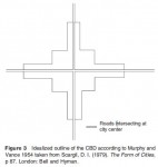
Just as the CBD has evolved through a number of different stages there have been various attempts to delimit its boundaries traditionally defined by a 'blighted zone' (of discard), characterized by obsolete and deteriorated property. At the most visible level the CBD can be delimited by the highest buildings, the heaviest concentration of traffic and pedestrian flows, and a large daytime […]

Evolution of the CBD
As the geographical concentration of commercial activity in the city, various CBD forms have been recognizable since at least the end of the eighteenth century. However, the manner in which the CBD functions is medieval as the linkages within the core area often need to be accessible by foot, which places an upper limit on the distance between functions that […]
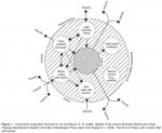
Defining the Central Business District
This core frame spatial organization is also evident in non Western cities like Cape Town where the CBD is flanked by industrial parks in the southern suburbs of Claremont, Rondebosch, and Wynberg. Similarly, in UK cities other activities requiring less relative centrality, including court houses and libraries, are located toward the edge of the core while functional nodes make up the surrounding […]
Central Business District
The central business district (CBD) is that part of the city which contains the principal commercial streets and main public buildings. Throughout history the CBD has been characterized by a number of land use changes that include industrial, residential, commercial, administration, and consumption. These spatial and temporal changes have been used to support and reject a number of theories and delimitations […]
Techniques and Examples
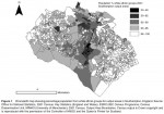
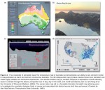
By far the most widely used cartographic representation of census data is the choropleth, or shaded area, map. The example provided in Figure 1 shows the 2001 census percentage of white ethnic groups in the city of Southampton, England. Values in the map are based on the aggregation of all the individual census results within each output area, clearly revealing […]
The Role of Census Mapping
Modern census organization involves the coordination of a very large workforce and geographical information systems (GISs) are routinely used to manage the logistics of enumeration. This organizational mapping does not generally form part of published outputs but nevertheless underpins the operational success of the census. Successful geocoding of individual census returns, linking them to the appropriate areas, is essential if counts […]
The Place of Censuses
Censuses of population play an important part in the government of nations, particularly with regard to the spatial allocation of resources. The earliest modern censuses, from which results have been widely published, can be dated from around the start of the nineteenth century, with the first census of population in 1790 in the US and 1801 in England and Wales. Censuses […]
Census Mapping
Census mapping refers to the cartographic presentation of the results of censuses in order to reveal spatial patterns in the data. Despite difficulties in achieving complete enumeration, the high population coverage of censuses means that it is usually possible to obtain data for very small geographical areas which can form the basis for detailed maps. Censuses are usually administered […]
Applications
A vast range of demographic, socioeconomic, and related analyses are based on census data, and those mentioned here are only indicative. In the past, census data were accessed through published volumes, but currently digital outputs predominate, ranging from online tabulations to customized data runs and the use of data labs. Data labs allow analysis down to the level of individual records, usually […]
Data and Geography Encoding
The historical development of the post enumeration processes of a census may be conceived in stages as shown in Table 1. Although the US census used some computer processing in 1950 (UNIVAC 1), most census data before the 1960s were manually encoded. Census agencies tended to adopt new computer technologies soon after they became available, and in some cases were significant contributors […]
Politics of Classification: Ethnicity and Religion
Two of the most contentious of census variables are race/ethnicity and religion. On one level, this relates to the perception that these are private and sensitive issues, and many censuses present a question on religion as optional. More fundamentally, especially in the case of ethnicity, the politics of classification are significant, since 'ethnicity' is a term incorporating aspects of […]
Geographies and Politics of Households and Family
Although households have served as one of the two basic units of census enumeration, they represent a complex series of debates within the social science literature. In Progress in Human Geography there has been an ongoing debate about the pivotal role of the household in shaping the geographies of gender, home, and everyday life. For example, studies of urban gentrification and […]
Population Coverage and Undercount
Although the ideal of census agencies is a 100% enumeration, most censuses fall short of that, and the rate of response is partly dependent on whether a census is compulsory or not. Although participation in the census in most countries is in theory compulsory, in reality it is not always possible to enforce. In the United States census of 2000, […]
Census Enumeration and Analysis
Although enumeration and analysis are generally considered as separate stages of the census process, technological changes have resulted in the boundaries between these processes becoming blurred since many of the same issues are found in both. The basic units of enumeration of most population censuses are the individual and the household. These are also the most common units of census […]
Census Implementation
History of Census Taking It is not known when the first census was taken, but there is evidence of census taking nearly 6000 years ago, with occurrences recorded in Egypt, China, Babylonia, Palestine, and Rome. Early censuses were undertaken especially for the purpose of military conscription, but were also used for purposes of taxation and labor requirements of […]
Census Geography
This article adopts a broader definition of census geography than is sometimes used. The more narrow definition, often used by statistical agencies, focuses on the spatiality of census taking and analysis, whereas this article also considers issues of census implementation and the techniques used by geographers and others in census analysis as well as the applications to which census data are […]
The Future for Cellular Automata in Geographic Research
Research work in this area is focused on a broad range of interests. Development of new applications is still quite active, with new cellular automata models popping up for a variety of phenomena of geographic interest, with an associated growth in their use as test beds for theory, practice, and policy. Researchers have also begun to focus on extending the basic […]
Geographic Applications in Other Sciences
Cellular automata have also been used in a variety of social science applications outside the geographic sciences, largely due to their value in representing geography in simulation. Cellular automata with fundamental space–time representations have been used in anthropology, to model the formation of societies and in political science and sociology to explore civil violence. Cellular automata have been […]
Human Geography Applications
Cellular automata have been employed in the study of a wide range of geographic phenomena. The plethora of applications is illustrative of the usefulness of the approach. Human geography applications are largely focused on issues relating to urban geography and behavioral geography. Models of urbanization and urban growth feature prominently in the literature. Cells are generally used to represent areas […]
The Advantages of Cellular Automata Modeling in the Geographic Sciences
Cellular automata have many advantages for geographic modeling. They are capable of supporting very large parameter spaces for simulation. A one dimensional CA with a binary state set and 13 cells has 213 possible configurations. A two dimensional version of the same CA has 2169 possible configurations, and a three-dimensional CA with the same specification has 22197! If we were to […]
Cellular Automata: A Primer
Automata are, fundamentally, computing media. Their origins date to Turing's work on computable numbers in the 1930s. Examples from the computer sciences include finite state machines, Turing machines, and artificial neural networks. These basic computing automata may be characterized as follows: where A represents an automaton, characterized by states S and a transition rule R. The transition rule functions to manage changes […]
Cellular Automata
Application of cellular automata to the study of geographical phenomena dates to the late 1960s and development of land use change models by Chapin and Weiss. While famous today for the invocation of Tobler's first law, a short paper on urban growth modeling by Waldo Tobler in 1970 is among the earliest examples of geographers' use of cellular […]
Capitalist Processes in the Making
Creation and Circulation of Capital Within the contemporary world economy, the dominant sets of relationships are increasingly capitalist in nature. Further, through rapid globalization a globalizing capitalist economy is emerging. This landscape means abstract understanding of capitalism can be deployed to, first, understand the relational basis of capital's existence and the pressures for particular behaviors that spring from crucial interactions […]

Contesting Abstractions
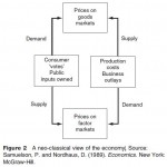
Neoclassical Economics In the abstractions of neoclassical economics, exchange is regarded as equivalent in and amongst all commodity markets, including the labor market. Consumers and producers have equivalent status as markets are paramount. The general structure of commodity exchange in terms of prices and relationships involving price is regarded as sufficient to characterize the whole economy. Buyers and sellers freely enter […]
Trying to Understand a Changing World
Academic interest in capitalism as a category of social organization stems from attempts to summarize how peoples at different times and places in history have sought to organize activities aimed at ensuring their survival, reproduction, and prosperity when faced with uneven availability of and access to resources. Categories such as capitalism both derive from and encourage politically laden questions either indirectly by […]
Capitalism
You are invited to ask the next person you meet after reading this article what they understand capitalism to be. Chances are, you will be quite shocked. In most peoples eyes capitalism is a dangerous word. The freight of politics past and present makes it a very sticky word. It carries so many negative connotations and imaginaries that to say the […]
Large Corporations, Political Regulation, Fordism, Mass Production, and Economies of Scale
In the last quarter of the nineteenth-century, the control and direction of large areas of industry came increasingly into the hands of banks and financiers. This era has thus come to be dominated by finance capitalism, characterized by the growth of large corporations – some of them developing into mammoth industrial cartels. The development of increasingly complex systems of […]
Geographies of Modern Capitalism
Though progress has been neither uninterrupted nor straightforward, the period since the last quarter of the nineteenth-century has seen the global triumph of capitalism. Indeed, the pace of change accelerated markedly during the twentieth century: the transformation of Western economies and societies that occurred during the 1900s as a result of immense technological advances is utterly without precedent. But there have […]
Geographies of Early Capitalism
Within the context of the theoretical and conceptual ideas outlined so far, it is now appropriate to examine the historical development of the capitalist system and the division of labor in the period since the late Medieval decline of feudalism. From Feudalism to Capitalism Though the term itself was coined only in the seventeenth century, feudalism describes a range […]

Theoretical and Conceptual Ideas
The Human Imperative to 'Truck, Barter, and Exchange' Among many writers who have offered theoretical explanations for the workings of capitalism, the first was Adam Smith, the Scots born philosopher and historian. Largely as a result of his 1776 book, An Inquiry into the Nature and Causes of the Wealth of Nations, Smith is regarded as the intellectual father of […]
Capitalism and Division of Labor
Capitalism is a socioeconomic system in which goods and services are produced for profitable exchange in a free market. The means of production are mostly in private ownership. As capital is accumulated, it is reinvested in further production. Investment decisions are usually made privately, and production and distribution are mainly controlled by independent companies that operate in competition with each other. The […]
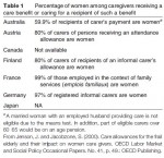
Toward an Inclusive Geography of Care and Caregiving
In this short article, we examined the dynamic and changing geographies of care and caregiving. This field of study evolved out of the combination of subdisciplinary developments in medical/health geography, and out of broader concerns for the implications of changes in healthcare policy and practice in Western developed countries. We reviewed the diverse set of theories and concepts that inform geographical approaches […]
Places and Spaces of Care and Caregiving
There is a growing body of work that explores the meanings and experiences of care and caregiving in various settings including healthcare institutions, communities, homes, and the body. The characteristics, meanings, and experiences associated with these four spaces of care and caregiving affect the organization and delivery of care, and the relationships, experiences, and practices involved in providing and receiving care. […]
Theorizing and Conceptualizing Care and Caregiving
Within geography, a central concern has been to elucidate the spatial manifestations and characteristics of care and caregiving in people's everyday lives with the explicit purpose of challenging taken for granted assumptions within prevailing health policies and practices. There are, however, many different and often contested ways to think about care and caregiving, and main contributions have come from, among others, […]
Geographies of Care and Caregiving
The importance of care and caregiving as a field of study can be understood as part of the general shift toward greater emphasis on the social aspects of healthcare, and as part of the response within the social sciences to broader changes in contemporary health policy and practice in Western developed countries such as Canada, New Zealand, and the United Kingdom. […]
Care/Caregiving
Care and caregiving involves a diverse and complex web of interventions, relations, and practices that occur between people in various traditional and nontraditional health and social care settings – all of which are intrinsically geographical. In this article, we examine geographical contributions to understanding care and caregiving beginning with a review of its roots within human/health geography with specific […]
Problems and Limitations of Animation
Beyond the problem of split attention mentioned above, psychologist Barbara Tversky and her colleagues have identified four major challenges when people watch and learn from animated graphics (including maps) as compared to the static graphics of the same data: Attention: In any visually rich display, especially in an animated map where many things can be happening simultaneously, readers are often […]
Nontemporal Animated Maps
Animated maps do not have to depict temporal data. One kind of a nontemporal animated map is a fly over map that simulates the experience of 'flying' over a digital landscape or zooming into or away from a location (as is possible with Google Earth). Most often with fly overs the map itself is static (e.g., the colors of the […]
Temporal Re-Expression, Filtering, and Interpolation
Although the most obvious way to animate spatiotemporal data is to simply play the data in the same sequence as it was collected (e.g., day 1 – frame 1, day 2 – frame 2, and so on), this is not always very insightful because: (1) the data may be very complex and contain multiple meaningful patterns, and/or (2) the […]
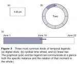
Temporal Animated Maps
Static maps present all of their information simultaneously; animated maps present information over time. Thus, animated maps have an additional representational dimension that can be used to display information. While it obviously takes time for a reader to scan a paper map, such as retrieving specific rates, the overall or holistic impression of the map happens at a glance. Moreover, […]
History of Animated Maps
The history of animated maps is very much tied to the history of computers. Early examples of animated maps were produced in the 1930s using hand drawn, cel based techniques borrowed from cartoon animation. Because these manual techniques were exceptionally time consuming, academic cartographers and computer scientists started experimenting with the potential of computer assisted animation surprisingly early (late 1950s) and […]
Cartographic Animation
Animated maps, sometimes called movie maps or change maps, are primarily used to depict geographic change and processes. Cartographers have long been interested in the potential of map animation because representing complex geographic processes on static maps is a significant challenge. Put simply, animated maps are appealing because we live in an animated world. Humans also possess an eye–brain system […]
Cartography and Surveying in Iran in the Twentieth Century
In the twentieth century, cartography developed in Iran in three sectors – private cartographic and surveying companies, the army, and governmental civil institutions. The first private cartographic company, Sahab Geographic & Drafting Company, was founded in 1315 h sh/1936 by 'Abdolghasem Sahab (1265–1335 h sh/1886–1956) and led for most of the century by his son 'Abbas Sahab (1300–79 h […]

Functions and Purposes
Maps, charts, plans, diagrams, and tables served a variety of functions and purposes in Islamic societies although the bulk seems to have spent their life in manuscripts, that is, in the spheres of educated readers. The earliest usage of maps seems to have happened when the armies of the newly converted Arab tribes invaded regions of Iran and Central Asia. The […]

Cartographic Genres and Practices
In addition to the world and regional maps, portolan charts, and handbooks for sailing directions discussed in the previous section, a number of other cartographic formats were developed in Islamic societies. Early in the ninth century, or perhaps even in the eighth century, the question of how to determine from any given place the direction toward Mecca was raised. David A. King […]
Cultures of Mapmaking
Mapmaking in Islamic societies took its themes, methods, techniques, and formats from several societies that either existed before the emergence of Islamic societies or parallel to them. The regions where these societies flourished were Greece, Egypt, Iran, India, China, Spain, Italy, the Netherlands, and France. With the shifts and changes in Europe since the sixteenth century, further European societies became relevant […]
Cartography in Islamic Societies
In Islamic societies, cartographic activities were part of courtly patronage and diplomatic exchange, educational literacy and scientific study, religious rituals and reminiscence, entertainment and the arts, and to some extent of war, seafaring, and administration. Many of the extant cartographic products are parts of manuscripts. Words, narratives, numbers, tables, and geometrical figures organize, structure, delineate, and interpret them. Books […]
Historical Cartography
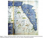
A second form of geographical and historical investigation about the past involves maps compiled from data relating to an earlier situation. Interpreted generously as the writing of history with maps rather than words, the practice is older and the reasons for it more diverse than is generally described. In the thirteenth and fourteenth centuries, for example, maps of the world […]
The History of Cartography
The division of the history of cartography into 'old' and 'new' came about in the penultimate decade of the twentieth century. Examples of the use of the word 'cartography' in Germany as early as the second decade of the nineteenth-century have been found, but the idea of a formal history of cartography for the study of old, that is, nonmodern, maps […]
The History of Maps and Mapping
That new approach emerged in the 1980s, propelled by factors both external and internal. External to – one might say foreign to – the world of cartography was the French theoretical and philosophical post structuralist movement led by Michel Foucault and Jacque Derrida that had already found fertile ground in the humanities (including geography) in Europe in the late 1970s. […]
Cartometrics
Cartometrics, which involves the detailed assessment of the mathematical structure (geodetical accuracy) of a map, is still in its infancy as a potentially powerful tool in the historical study of early maps. The modern emphasis on understanding the social context from which a map emerged does not in any way exclude the need to understand also the technical processes of map […]
Cartobibliography: The History of Printed Maps
The indispensable step in approaching a map (or anything) to be used as evidence is to check its publication history and its credentials as a source in the same way as a bibliographer examines a book. The discriminating description of maps is known as cartobibliography, a term first used in 1914 by George Fordham in the title of […]
Infrastructure
Despite the relevance of maps to many fields of historical study in the humanities and the social sciences, academic responsibility for the study of early maps has tended to be nobody's business. Full length university courses are rare (there are at present only two professorial chairs in the subject in the world, both in the USA). A promising new development at […]
Approaches to the History of Cartography
For geographers, the relationsip between maps and history has taken several forms. The terms used to describe each form are not synonymous; the 'history of cartography' is not the same thing as 'historical cartography' or the 'history of mapping', although in practice the boundaries between the categories of activities noted below are neither precise nor impermeable. Many studies conducted under […]
Cartography, History of
The ubiquity of maps today is beyond dispute. They are treasured as decoration in private and public places, and enjoyed in exhibitions. Whether in manuscript or print, or on television, maps are the workhorses of weather forecasters, reporters, political and cultural commentators, cartoonists, textbook writers, scientific researchers, administrators, and planners alike. As printed road atlases (or, increasingly, electronic satellite navigation systems), they […]
Issues and Challenges of the Case Study Approach
Use of the case study approach in both teaching and research has been criticized for more than five decades. Indeed, unlike this reference book, many research and pedagogy guidebooks fail to include the case study approach in their discussions. The reasons for this are twofold. First, case study research has been criticized for: (1) its unscientific nature (because findings cannot […]
Using the Case Study Approach to Teach Human Geography
Case studies are useful not only in research, but also in classroom instruction in human geography. One of the many strengths of this type of teaching and learning is that it is one of the most effective ways to link research and teaching in geography classrooms at all levels of instruction. During the past decade, a spate of books and articles […]
Methods Useful in Case Study Research
Particular attention must be paid to considering how best to test for reliability and validity when assembling the methods used to conduct case study research. One of the best ways to accomplish this is to use multiple sources of evidence including the use of such approaches to data gathering as interviews, survey questionnaires, field observation, textual analysis, participant observation, analysis […]
Types of Case Studies
At least five different types of case studies have been discussed in the geography and social science literature: intrinsic, collective, explanatory, descriptive, and exploratory. In each of these types, there may be single case or multiple case approaches used. An intrinsic case study is defined as research wherein the researcher has a (personal or professional) interest in the project. In […]
Case Study Approach
The case study approach in human geography is useful in both research and teaching, particularly when an in depth investigation is needed. The study of a single place, a particular group, or a specific issue in one location is helpful in narrowing down research topics. Such topics are often more manageable and meaningful for both early career geographers and more experienced […]
Capital’s Consumption Spatiality
Capital makes space not just for accumulation. Spaces of consumption are also important without which value will not be realized. But spaces of consumption are also usevalues that labor demands. For example, housing is an important working class demand. Capital, however, uses it as a means of investment: housing and the like can absorb a lot of surplus capital staving […]
Capital and Space: Capital’s Crisis-Spatiality
Capital accumulation and its relation to space cannot be looked at without a serious attention to the contradictory character of capital. There are four major types of contradiction. Each of these is a dimension of the main contradiction: the contradiction between social relations and productive forces under capitalism. The use of space is crucial to the partial alleviation (or temporary […]
Capital and Space: Capital’s ‘Normal’ Spatiality
Each phase in the circuit of capital has a corresponding spatial form. There are thus spaces of production, spaces of realization (capital realizes the surplus or profit when the product is sold), and spaces of accumulation (where a part of the surplus/profit is reinvested). An interesting aspect of these spaces is the mutual incongruence between these spaces: commodities produced in […]
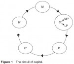
How Does Capital Work?: Mechanisms of Capital
To understand how capital works, the author returns to Marx's general formula for capital as he outlines in chapter 4 of Capital vol 1: M–C–M0, which can be expanded into: M … C [MP, LP] … P … C0 …M0 (see Figure 1). The general formula means that: the owner of capital invests money (M) to buy commodities (C) which include means of production […]
Capital and Space
Tools, machines, and other types of means of production are considered to be capital in many conventional economic geography texts. In this view, capital is not only a tangible thing but also a transhistorical thing. In a slightly more general view, capital is defined as any incomegenerating asset that generates some benefit, including income. Using capital metaphorically, scholars talk […]
Business Service Geographies – Global Cities, Service Offshoring, and the Second Global Shift
Global Cities Business services have a complex geography that reflects the existence of concentrations of clients in major cities or in the global cities of London and New York. Business services have been growing rapidly not only in the major cities, but also in locations further down the urban hierarchy and even in rural locations. Conventionally, it has been assumed […]
Business Services – the Body and Emotional Labor
Successful business service entrepreneurs possess three important attributes: professional expertise, an existing reputation (sometimes iconic), and a network of client contacts. These essential requirements for competitive success explain the concentration of founders' previous employment in same sector or client firms, and into larger rather than smaller companies. The founders of business service firms acquire their reputations, expertise, and client contacts while working for […]
Explaining the Growth of Business Service Firms
The tendency for firms to externalize or outsource functions and activities previously produced in house (internalized) is one of the best known hypotheses used to explain the rapid relative growth of business services. It has its origins in research on the importance of complementarity and economies of scale for decisions by firms about whether to externalize or internalize service functions. The […]
Characteristics of Business Service Firms
The growth in employment in business services was also reflected in extremely high rates of new firm formation. Business services were the main contributors of UK small firm service sector growth in the 1980s and 1990s. Not only were business service growth rates generally slightly higher than those for consumer service sectors, but business services generated nearly 3 times as […]
Measuring Business Services in National Economies
The ongoing structural realignment being experienced by economies makes it impossible for governments to ensure that their national economic statistics are an adequate reflection of economic activity. This has always been the case. The UK Standard Industrial Classification of Economic Activity (SIC) is a measure of economic activity, but essentially it is a backward looking measure; the SIC cannot be constantly […]
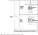
Defining Business Services
The academic literature on business services has its foundations in a ground breaking monograph published by Harry Greenfield in 1966. In this classic work, Greenfield argued that the consumer/producer dichotomy with respect to goods could also be applied to services. Consumer goods are produced to satisfy final demand while producer goods (machine tools, etc.) are intermediate inputs that contribute to […]
Business Services
Developed market economies have been experiencing a process of structural change over the last two decades that has involved two related alterations. First, a process of de industrialization in which manufacturing's share of employment and output has been declining and, second, compensating growth in employment and output in services and especially in business services. Business services add value to their […]
New Issues
The international frontier carries memories of past tensions that are related to the persistence of geographical factors or to the inertia of cultural geography. With the end of the Cold War, many parts of this international frontier became destabilized again. The return of war to Europe has led to ethnic cleansing, diminishing again the potential of many areas to function […]
Buffer Zones and the International Frontier
Global and Large-Scale Outlooks At a high level of geopolitical generalization, buffer zones appear as separating large areas unified by religion, empire, ideology, or culture. With the rise of Islam, the Mediterranean Sea became a buffer zone between Christian Europe and Muslim North Africa. Charlemagne's empire, divided in three parts at Verdun in AD 843, led to a historical buffer […]
Buffer States
A buffer state is a relatively weak state lying between two or more antagonistic powers of comparable potential. Conditions for Buffer State Status The geographical condition seems paramount. The buffer state must be in contact with the territory of the other powers and must separate them. However, this separation may not be complete. Thus, for example, the fact […]
Buffer Zones as Peripheries of Territories
Ideally, buffer zones are neutral spaces between two or more territories. However, in many cases, buffer zones were organized by one power in order to cope with challenges or in order to take advantage of opportunities coming or existing in spaces dominated by less organized powers. In such situations, buffer zones are in fact peripheries of the territory of the […]
Buffer Zone
In its simplest definition, a buffer zone is an area between two or more adversarial powers, whose function is to physically separate them. It is thus conceived as an instrument of peace and stability. The word buffer conveys the idea of absorption of tensions, of cushioning. A buffer zone can exist at various geographical scales, in accordance with the […]
Tensions and Complementarities between the Green and Brown Agendas
Tensions clearly do exist between the brown agenda and the wider green movement. Indeed, it was partly due to a perceived neglect of local urban environmental issues by green organizations that urban development authors and practitioners started using the term brown agenda. However, solutions to brown agenda problems can be problematic from a green perspective – it is sometimes the case that […]
Main Elements of the Brown Agenda
Water Supply Access to safe water and sanitation are two of the most urgent problems associated with the urban environment in the developing world. Globally, 1.1 billion people do not have access to adequate water supplies and more than double that figure – 2.4 billion – lack adequate sanitation facilities. These problems are particularly acute for the urban poor in many […]
What Is the Brown Agenda?
In brief, the brown agenda refers to issues of safe water provision, sanitation, and drainage; inadequate solid and hazardous waste management; and air pollution including uncontrolled emissions from motor vehicles, factories, and low grade domestic fuels. The brown agenda emerged as a matter of concern and debate, in part, because of a perceived lack of attention to the specifically urban environmental […]
Brown Agenda
With the increasingly high profile of global environmental concerns from the 1980s, the urban agenda for developing countries has seen progressive shifts toward a focus on urban environmental issues, collectively termed the 'brown agenda'. The most critical and immediate development issues facing cities of the developing world – those of water supply, sanitation, and waste management – were reconceptualized through an […]
An Evaluation of the Recommendations of the Brandt Commission
Behind the individual measures called for by the Brandt Commission, there were two key dimensions. The first was a need for the large scale transfer of resources to the countries of the South. The second was the recognition of the global mutuality of development and the need to act on such interdependence. In both these senses, the Brandt Commission's recommendations were […]
The Principal Recommendations of the Brandt Commission
In a passage that today seems remarkably prescient, the Commission's Report North–South clearly pinpointed what it saw as the principal threats to global order: If reduced to a simple denominator, this Report deals with peace. War is often thought of in terms of military conflict, or even annihilation. But there is a growing awareness that an equal danger might be […]
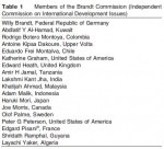
Membership of the Commission and the Schedule of Meetings
Willy Brandt regarded it as essential that the Commission was independent and that its members, no matter their background, should be invited to serve in a strictly private capacity. The Commission also wanted to ensure that the majority of its members were drawn from what were frequently described at the time as Third World (Southern) countries. The eighteen commissioners are […]
Brandt Commission
Introduction: Background to the Independent Commission on International Development Issues (the Brandt Commission) and Its Report (the Brandt Report) The Brandt Commission, properly known as the Independent Commission on International Development Issues (ICIDI), was established in 1977 with the express aim of examining the world's development needs in the 1980s and beyond. In the words of the Commission's Report, the intention was to […]
Lack of Data
Hampering the ability to understand global patterns of skills migration and to develop policy responses is a lack of reliable information. There is a critical absence of hard data on migrant stocks and flows, their human capital content, and the actual impacts (negative and positive) of skills migration from particular developing countries. A recent exception is an econometric study on the […]
Global Cooperation
Despite the conflict of interests at the table, there are signs of cooperation. The United Kingdom and the Commonwealth have developed protocols to address the recruitment of healthcare workers and teachers from developing countries. As well, the General Agreement on the Trade in Services (GATS) may open the door to a more coordinated and mutually beneficial international mobility of skilled workers. The […]
Policy Prescriptions and Possibilities
With the international mobility of highly skilled workers forecast to increase, many countries and regional groupings of states are taking steps to coordinate and implement policy responses. Most authors agree that countries must do away with a laissez faire approach. Strategic immigration and development aid policies must be developed, aimed at effective management of human capital that produces a win win situation […]
Feedback Effects
Adherents of the revisionist approach emphasize the positive potential of skills out migration for Africa, Asia, and Latin America. The loss of the highly skilled may not always mean a loss for economic development. The revisionists assert that brain drain is a temporary stage and that a brain gain may actually result. Along with the migrant and receiving country, the […]
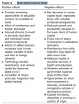
Impacts of Brain Drain
What does it mean for Asian, African, and Latin American countries that lose skilled professionals to developed countries? Traditionally, skills out migration has been seen as an unqualified negative for these countries; the very term brain drain suggests as much. Certainly the general tenor of current policy thinking is that skills migration produces a general 'brain strain' on development. While information technology […]