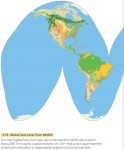
Mapping Global Land Cover by Satellite
Imagine yourself as an astronaut living on an orbiting space station, watching the Earth turn underneath you. One of the first things that would strike you about the land surface is its color and how it changes from place to place and time to time. Deserts are in shades of brown, dotted with white salty playas and the black spots and streaks of recent volcanic […]
Color, Mapping
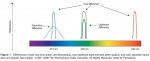
Introduction The word color is often associated with sensations that are named, such as red, blue, purple, and brown. However, the phenomenon of color is actually multidimensional. Color can be differentiated along three different dimensions: hue, lightness, and saturation. Color hue is related to the wavelengths of light that are perceived by the map reader, and is typically described […]
Children and Mapping
The topic of children and mapping is a special subject within the broad area that examines the ways people see and interpret maps. Children are a special case of map users for two reasons. The first one pertains to the relation between the development of children's conception of space and that of cartographic understanding. The theories of the children's spatial […]
The Role of Census Mapping
Modern census organization involves the coordination of a very large workforce and geographical information systems (GISs) are routinely used to manage the logistics of enumeration. This organizational mapping does not generally form part of published outputs but nevertheless underpins the operational success of the census. Successful geocoding of individual census returns, linking them to the appropriate areas, is essential if counts […]
Census Mapping
Census mapping refers to the cartographic presentation of the results of censuses in order to reveal spatial patterns in the data. Despite difficulties in achieving complete enumeration, the high population coverage of censuses means that it is usually possible to obtain data for very small geographical areas which can form the basis for detailed maps. Censuses are usually administered […]
The History of Maps and Mapping
That new approach emerged in the 1980s, propelled by factors both external and internal. External to – one might say foreign to – the world of cartography was the French theoretical and philosophical post structuralist movement led by Michel Foucault and Jacque Derrida that had already found fertile ground in the humanities (including geography) in Europe in the late 1970s. […]
Key Challenges within Biodiversity Mapping
Despite important advances in biodiversity mapping, there remains a variety of critical debates surrounding biodiversity mapping approaches. A key issue is the challenge of collecting and combining appropriate data with which to make conservation decisions. A lack of appropriate data has led to questions over the validity of results, particularly in the contexts of developing countries and the biodiverse tropical regions […]
Biodiversity Mapping: History
The mapping of species distributions has a long history in geography. As far back as the early 1800s, Alexander von Humboldt described the latitudinal and altitudinal distributions of vegetation zones, and others continued such practices until methods were eventually formalized within the subdiscipline of biogeography. In other disciplines, too, particularly biology, the notion that place matters in ecological processes and patterns […]
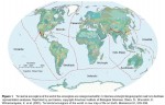
Biodiversity Mapping
The term 'biodiversity mapping' encompasses a variety of techniques used to represent and analyze patterns of biodiversity, and is almost always used within the framework of environmental conservation. Although maps of biodiversity can be useful simply as a way to represent complex environmental data in an easily interpretable form, usually biodiversity mapping involves further analysis and manipulation of the data in […]
facilities mapping
FACILITIES MAPPING (FM) is the process of digitally identifying and mapping facilities infrastructure with the explicit goal to improve operational management and planning tasks such as dispatching, inventorying, and maintenance. Some examples of facilities include utilities (gas, water, telephone, and electricity), airport siting, and transportation planning. In the past, when a facilities map was needed, […]
computer mapping
COMPUTER MAPPING IS the general term used to describe the process of developing digital maps from aerial photographs, satellite images, global positioning systems (GPS) records, paper maps, and other archival data sources. GEOGRAPHIC INFORMATION SYSTEMS (GIS) are currently the most common implementation of computer mapping systems. A GIS consists of an organized collection of computer […]