Clouds
Clouds are frequent features of the atmosphere. Views of the Earth from space show that clouds cover about half of the Earth at any given time. Low clouds reflect solar energy, thus cooling the Earth–atmosphere system, while high clouds absorb outgoing longwave radiation, thus warming the Earth–
atmosphere system. One of the most familiar roles of clouds, however, is in producing precipitation.
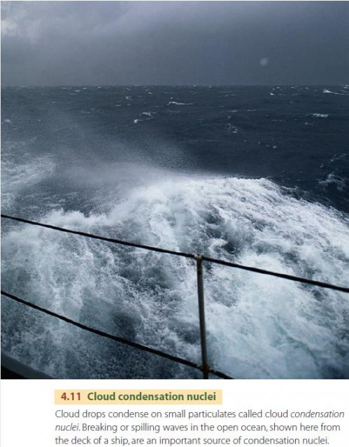
Clouds are made up of water droplets, ice particles, or a mixture of both, suspended in air. These particles are between 20 and 50 ?m (0.0008–0.002 in.) in diameter. Cloud particles do not form in empty space. They need a tiny center of solid matter to grow around. This speck of matter is called a condensation nucleus and typically has a diameter of 0.1–1 ?m (0.000004–0.00004 in.).
The surface of the sea is an important source of condensation nuclei. Droplets of spray from the crests of the waves are carried upward by turbulent air, shown in Figure 4.11. When these droplets evaporate, they leave behind a tiny residue of crystalline salt suspended in the air. This aerosol strongly attracts water molecules, helping to initiate cloud formation. Nuclei are also thrown into the atmosphere as dust in polluted air over cities, aiding condensation and the formation of clouds and fog.
If you ask, “What is the freezing point of water?” most people will reply that liquid water turns to ice at 0°C (32°F). This is true in everyday life, but when water is dispersed as tiny droplets in clouds, it behaves differently. Water in clouds can remain in the liquid state at temperatures far below freezing. In that case, we say the water is supercooled. In fact, clouds consist entirely of water droplets at temperatures down to about ?12°C (10°F). As cloud temperatures drop below that value, ice crystals begin to appear. The coldest clouds, with temperatures below ?60°C (?76°F), occur at altitudes above 12 km (40,000 ft) and are made up entirely of ice particles.
CLOUD FORMS
Anyone who has looked up at the sky knows that clouds come in many shapes and sizes (Figure 4.12). They range from the small, white, puffy clouds often seen in summer to the gray layers that produce a typical rainy day. Meteorologists name clouds by their vertical structure and the altitudes at which they occur.
Stratiform clouds are blanket-like and cover large areas. A common type is stratus, a low cloud layer that covers the entire sky. Dense, thick stratus clouds can produce large amounts of rain or snow. Higher stratus clouds are referred to as altostratus.
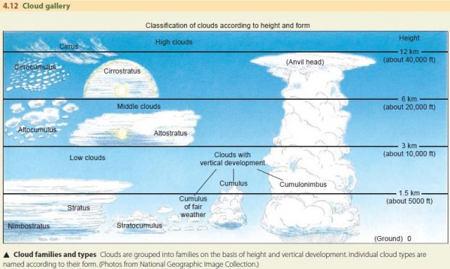
Cirrus clouds are high, thin clouds that often have a wispy or patchy appearance. When they cover the sky evenly, they form cirrostratus.
Cumuliform clouds are clouds with vertical development. The most common cloud of this type is the cumulus cloud, which is a globular cloud mass associated with small to large parcels of rising air starting near the surface. However, there are also altocumulus—individual, rounded clouds in the middle layers of the troposphere—and cirrocumulus—cloud rolls or ripples in the upper portions of the troposphere.
Nimbus clouds are clouds that produce rainfall. Thus, nimbostratus is a thick, flat, rain cloud, and cumulonimbus is a cumulus rain cloud.
FOG
Fog is simply a cloud layer at or very close to the Earth's surface. For centuries, fog at sea has been a navigational hazard, increasing the danger of ship collisions and groundings. In our industrialized world, it can be a major environmental hazard. Dense fog on high-speed highways can cause chain-reaction accidents, sometimes involving dozens of vehicles. When flights are shut down or delayed by fog, it is inconvenient to passengers and costs airlines money. Polluted fogs, like London's “pea-soupers” in the early part of the twentieth century, can injure urban dwellers' lungs and take a heavy toll in lives.
One type of fog, known as radiation fog, forms at night when the temperature of the air layer at the ground level falls below the dew point. This kind of fog forms in valleys and low-lying areas, particularly on clear winter nights when radiative cooling is very strong.
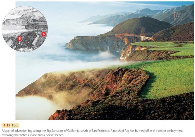
Another fog type—advection fog—results when a warm, moist air layer moves over a cold surface. As the warm air layer loses heat to the surface, its temperature drops below the dew point, and condensation sets in. Advection fog commonly occurs over oceans where warm and cold currents occur side by side. When warm, moist air above the warm current moves over the cold current, condensation occurs. Fogs form in this way off the Grand Banks of Newfoundland because here the cold Labrador current comes in contact with the warmer waters of the Gulf Stream.
Advection fog is also frequently found along the California coast, as seen in Figure 4.15. It forms within a cool marine air layer in direct contact with the colder water of the California current, and it is frequently carried ashore by westerly winds. Similar fogs are also found on continental west coasts in the tropical latitude zones, where cool, equatorward currents lie parallel to the shoreline.