Congo River
FROM ITS SOURCE on a savanna PLATEAU just south of Lake TANGANIKA, the Congo River flows some 2,880 mi (4,630 km) through equatorial africa before eventually emptying into the ATLANTIC OCEAN. While no other major river in the world transects the equator even once, the Congo River twice crosses the equator in its journey to the sea. The river flows through an immense and relatively flat drainage basin that lies more than 1,000 ft (300 m) above sea level. The Mitumba Mountains and the Ruwenzori Range form the eastern rim of the basin, while high plateaus rim the drainage basin in the north and south. A narrow westward outlet allows for the exit of the basin's surface water.
At 1.34 million square mi (3.46 million square km), the Congo River basin is the second-largest drainage basin in the world and receives an average of 60 in (152 cm) of rain annually.
This significant precipitation total is attributable to the fact that the river flows through both the Northern and Southern Hemispheres in a humid equatorial climate. As it is always the rainy season on one side of the equator, the Congo River avoids any notable change in volume from alternating wet and dry seasons.
By contrast, rivers in the savanna region of Africa often experience significant flow reductions during the dry season. Consequently, though only approximately 370 mi (600 km) longer than the NIGER RIVER, the Congo River discharges nearly eight times as much water into the Atlantic Ocean. Emptying into the ocean, the flow rate of the Congo River is second in the world behind only the AMAZON RIVER. However, as it is draining a basin in a humid equatorial climate, the tremendous discharge of the Congo River represents only 3 percent of its potential basin runoff.
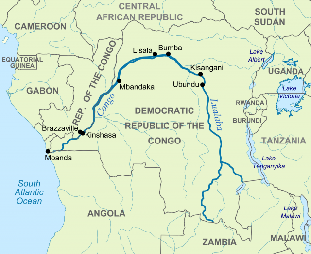
Looping north and west in a great arc from its headwaters in the Katanga province, the Congo River receives input from several substantial tributaries. These rivers include the Kasai, Ubangi, Luvua, which emanates from Lake Mweru in the far southeast, and the Lualaba, the principal stream of the upper course, considered by many to be the main branch of the Congo. In its relentless journey to the Atlantic Ocean, the width of the Congo varies from 3.5 mi (8 km) to 8 mi (12.8 km) and is divisible into three distinct sections—the Upper, Middle, and Lower Congo.
Characterized by waterfalls, lakes, and rapids, the Upper Congo includes a series of seven cataracts and rapids known as Stanley Falls. Extending over 60 mi (96 km), Stanley Falls demarcates the lower end of the Upper Congo and gives way to a lengthy stretch of navigable river along the Middle Congo. These navigable waters of the Middle Congo terminate just above Livingstone Falls and immediately downstream from the capital city of Kinshasha. A series of more than 30 cataracts, Livingstone Falls represents a turbulent 220 mi (354 km) stretch of the Congo River. Below the falls, the Lower Congo travels for approximately 200 mi (322 km) across the nearly level coastal plain before terminating in the Atlantic Ocean.
With an estuary approximately 7 mi (11 km) wide, the Congo River differs from other African rivers such as the Niger and the NILE in that it does not form a significant DELTA upon entering the ocean. However, it is similar to its African counterparts in that it has only limited navigability for significant portions of its course.
From its entry point into the Atlantic Ocean, for example, the Congo is navigable for only 85 mi (137 km) before reaching a series of rapids at the major fishing port of Matadi. Despite its inherent difficulty, river transport is an even greater necessity in the waters of the Congo than elsewhere in Sub-Saharan Africa. This same turbulence that renders many stretches of the Congo River impassable also contributes to the river's potential for hydroelectric power.
Owing to the speed and volume of its waters, the Congo River basin is the potential source of approximately 13 percent of the world's total hydroelectric power. Inga Falls, some 25 mi (40 km) upstream from the river port of Matadi, represents the largest hydroelectric power potential in Africa (and perhaps the world). Here water cascades downstream at a rate of 150,000 cubic ft (43,000 cubic m) per second as the river falls nearly 330 ft (100 m) in only 8.7 mi (14 km). Efforts to tap into the estimated 43,000 megawatts of generating capacity have thus far captured only a fraction of the potential power. Completion of two construction phases, Inga I (1972) and Inga II (1982), has netted only 1,700 megawatts of hydroelectricity. In 1999, plans for additional Inga stages were announced—with the ultimate objective being the capture of the entire power of Inga Falls by 2010. Despite its hydroelectric potential, concerns have been raised over the project's impact on the number of fish species and the viability of commercial inland fishing.
Like its river and tributaries, the entire Congo basin is difficult to traverse. Those pockets of the basin containing tremendous mineral wealth, including diamonds, cobalt and copper, have suffered intensive exploitation for decades. However, vast expanses of forest remain untouched and are home to such rare animals as the okapi and gorilla. Much of the forested basin has experienced only minimal human impact, such as when the Pygmies and other indigenous peoples use the forest for their hunting and gathering needs.
Agricultural activity typically includes the cultivation of bananas, maize, and sweet potatoes, as well as more commercially oriented crops such as coffee and sugar. Other economic activity involves raising goats and tending livestock. Despite only fairly limited economic exploitation of the region, the mineral wealth and hydroelectric potential of the Congo River basin are likely to attract increasing attention and activity in the future.