Congo
Area 132,047 square mi (342,000 square km)
Population 4.559 million (2014)
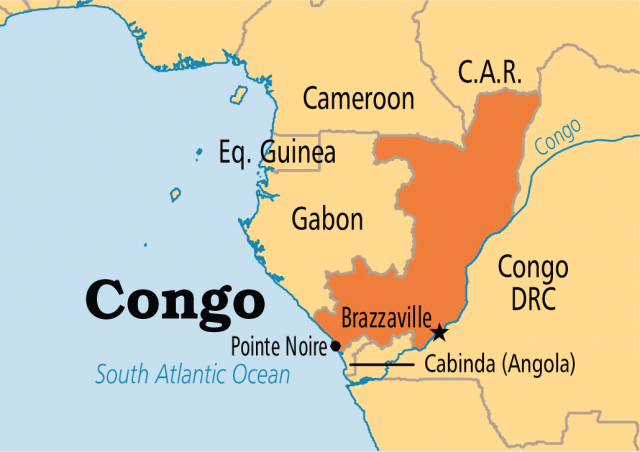
Capital Brazzaville
Highest Point 2,963 ft (903 m)
Lowest Point 0 m
GDP $14.14 billion (2014)
Primary Natural Resources petroleum, wood, potassium, potash, gold.
THE REPUBLIC OF Congo is located in western Africa and covers an area slightly smaller than MONTANA. It is bordered by GABON to the west, CAMEROON to the north, the Democratic Republic of the CONGO (formerly Zaire) to the east and south, the Angolan Cabinda enclave to the southeast, and the ATLANTIC OCEAN to the east. Congo's border with the Democratic Republic of Congo is the country's only natural boundary, which follows the CONGO and Ubangi rivers. Congo gained its independence from FRANCE on August 16, 1960.
Congo has a tropical climate that is warm and humid with heavy rainfall occurring mainly from March through June. Dense tropical RAINFORESTs start at the equator and cover the northern part of the country. South of the equator, there is a savanna area with diverse wildlife, including antelope, giraffe, cheetah, and crocodile, along with many birds and snakes. Also encountered in the southern part of Congo are central plateaus, fertile valleys, and coastal plain and forested floodplain areas.
In the Congolese valleys are grown the primary subsistence crops of cassava and yams. Export crops, raised on plantations in this area, consist of sugarcane, tobacco, coffee, cacao, palm products, rice, corn, and groundnuts.
RIVER LIFE
Many of the rivers in Congo play a large part in the economic and commercial life of the Congolese people. There are over 2,300 mi (3,700 km) of navigable rivers in the country. The main river routes are along the Congo and Ubangi rivers. Brazzaville, the capital of Congo, is a large river port along the Congo River. Because of the effectiveness of transportation along the rivers and the vastness of the northern rainforests, the Congolese road system has barely been improved, and today consists only of 7,450 mi (12,000 km) of roads.
The Congolese forests constitute one of the major natural resources in Congo and are the primary agricultural export of Congo. These timbers were the top export of Congo before the discovery of oil in the country and now constitute only 7 percent of export earnings. The majority of these trees are oil palms and okoume. Oil was first discovered in Congo in 1957 at Pointe Indienne. Since then, oil has been Congo's largest export, making up 89 percent of the export earnings in 2001. At that time, the Republic of Congo was producing 275,000 barrels of oil per day.
Congo is one of the most urbanized countries of Africa with over 85 percent of its total population living in the southwestern part of the country. Brazzaville has the highest population at over 800,000 people, followed by Pointe Noire with 450,000 people. The rest of the Congolese people live mainly in small cities or villages along the railroad connecting Brazzaville, located roughly 310 mi (500 km) inland along the Congo River, to Pointe Noire on the southern Atlantic Ocean. Along this railway lives more than 75 percent of the Congolese population. Even though Congo has a relatively concentrated population in these areas, the overall population density is low because vast areas of swamps and rainforest are uninhabited.
The ethnic diversity in Congo is also great. The Bantu people make up the majority of the population and include four groups. The largest group of the Bantu people is the Kongo, making up about 48 percent of the population. They are mostly farmers or traders, live primarily around Brazzaville, and speak Bantu. The Teke or Bateke, another Bantu-speaking group, make up 17 percent of the population. The remaining Bantu peoples are the Sangha and the M'Bochi. Also present in Congo are the country's first inhabitants, the Pygmies. There are fewer than 100,000 Pygmies in Congo today, and they live mainly in small tribal groups in the forests along the Congo River and in the rainforests north of the equator.