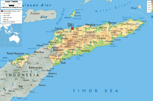
East Timor
Area 5,853 square mi (15,007 square km)
Population 1.212 million 2014
Capital Dili
Highest Point 9,778 ft (2,963 m)
Lowest Point 0 m
GDP $1.552 billion 2014
Primary Natural Resources gold, petroleum, natural gas, manganese, marble.
THE ISLAND OF Timor, in the Indonesian archipelagos, is no stranger to struggle. Disputed between the Dutch and Portuguese since the late 1500s, the island was officially split when the eastern portion declared independence from PORTUGAL in 1975, only to be immediately claimed by INDONESIA, setting off 25 years of violence and destruction.
The Democratic Republic of East Timor (or Timor Leste) forms the eastern half of the island of Timor, the easternmost (and largest) of the Lesser Sunda islands (in fact, “timor” simply means “east” in Malayan languages). The new nation also includes an enclave in the western half of the island (Oecussi-Ambeno), and an island off the northern coast, Atauro. Timor is located about 620 mi (1,000 km) east of JAVA, and about 300 mi (450 km) northwest of AUSTRALIA. The island is volcanic in origin and its terrain is mostly mountainous, with difficult access due to steep coasts and coral reefs.
Timor thus remained little explored until the later 20th century, and European influence was restricted to a few coastal settlements (mostly on the north coast) dependent on plantations of coffee, rice, sugar, and coconuts. The interior mountains contain considerable minerals, including gold, manganese, and marble, but these are largely unexplored. The discovery of large reserves of offshore petroleum and natural gas promises much for the future of the country, but is also a continuing source of tension between rival claims of the Indonesian and Australian governments.
Both Portuguese and Dutch trading posts were established on Timor in the 16th century, but it was not until 1913 that the Dutch formally recognized the Portuguese position in the eastern half of the island. Long after the Dutch East Indies became independent as Indonesia in 1949, the Portuguese colony of Timor declared itself independent in 1975. It was immediately occupied by Indonesia, however, and forced to assimilate with the rest of the island. After 20 years of violence resulting in the loss of between 100,000 and 300,000 lives (killed or missing), a United Nations-supervised referendum in 1999 resulted in renewed independence in May 2002, and East Timor became a new nation in September 2002.
The country's capital, Dili, built by the Portuguese in the 1620s, is located on the northern coast of the island and is being rebuilt after near complete destruction in 1999. At independence, East Timor was one of the world's poorest nations, with 70 percent illiteracy, 12 percent infant mortality, and an average life expectancy below 50 years. The country relies mostly on exports of timber and coffee, while it waits for resolution of its struggles with Australia over exploitation rights of the Timor Gap, the region of seabed off the southeast coast with large fossil fuel reserves. A settlement between Australia and Indonesia was reached over this prize in 1989, when East Timor was still under Indonesian occupation, and Australia is now unwilling to give up concessions to an area potentially yielding $29 billion in revenues. This conflict remained unresolved in 2004.