Europe: Human–Environment Interaction
A HUMAN PERSPECTIVE “1800 DIE IN WIND-WHIPPED FLOOD WATERS!” February 1, 1953, witnessed a disaster in the Netherlands. Winds estimated at 110 to 115 miles per hour piled up gigantic waves that ripped through dikes—earthen banks—holding back the North Sea. When the storm was over, 4.5 percent of the Netherlands was flooded, and thousands of buildings were destroyed. The Netherlands is prone to floods because much of its land is below sea level.
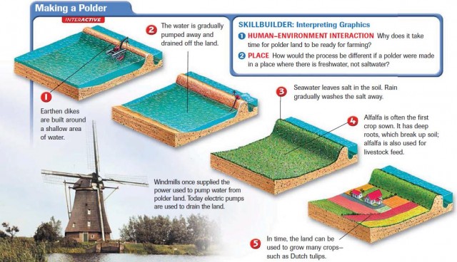
Polders: Land from the Sea
An old saying declares, “God created the world, but the Dutch created Holland.” (Holland is another name for the Netherlands.) Because the Dutch needed more land for their growing population, they reclaimed land from the sea. At least 40 percent of the Netherlands was once under the sea. Land that is reclaimed by diking and draining is called a polder.
SEAWORKS
The Dutch erected seaworks, structures that are used to control the sea's destructive impact on human life. Those seaworks include dikes and high earthen platforms called terpen. The dikes hold back the sea, while the terpen provide places to go for safety during floods and high tides.
Over the centuries, the Dutch found ways to reinforce the dikes and to control water in the low-lying areas the dikes protected. In the 1400s, the Dutch began using their windmills to power pumps that drained the land. When the French conqueror Napoleon viewed a site with 860 windmills pumping an area dry, he reportedly said, “Without equal.” Today the pumps use electric motors instead of windmills.
TRANSFORMING THE SEA
Another remarkable Dutch alteration of their environment was the transformation of the Zuider Zee. It was an arm of the North Sea and is now a freshwater lake. The idea was originally proposed in 1667. But it was not until the late 1800s and early 1900s that the Dutch perfected a plan to build dikes all the way across the entrance to the Zuider Zee. Since no saltwater flowed into that body of water, it eventually became a freshwater lake. It is now called Ijsselmeer. The land around the lake was drained, creating several polders that added hundreds of square miles of land to the Netherlands.
Waterways for Commerce: Venice's Canals
Like the Netherlands, Venice, Italy, is a place where humans created a unique environment. About 120 islands and part of the mainland make up the city of Venice. Two of the largest islands are San Marco and Rialto. A broad waterway called the Grand Canal flows between them. Moving people or goods in Venice depends upon using the more than 150 canals that snake around and through the islands. Consequently, to get from one place to another in Venice, you generally have two choices: take a boat or walk. Almost anything that is moved on wheels elsewhere is moved by water in Venice.
AN ISLAND CITY GROWS
Venice began when people escaping invaders took shelter on inhospitable islands in a lagoon. They remained there and established a settlement that eventually became Venice. The city is located at the north end of the Adriatic Sea, a good site for a port. As a result, trade helped Venice grow.
BUILDING ON THE ISLANDS
Building Venice required construction techniques that took into account the swampy land on the islands. Builders sunk wooden pilings into the ground to help support the structures above. So many pilings were required that oak forests in the northern Italian countryside and in Slovenia were leveled to supply the wood. The weight of the buildings is so great that it has compressed the underlying ground. This is one of the reasons that Venice is gradually sinking. Other reasons include rising sea levels and the removal of too much groundwater by pumping.
PROBLEMS TODAY
Severe water pollution threatens historic Venice. Industrial waste, sewage, and saltwater are combining to eat away the foundations of buildings and damage the buildings themselves. Erosion has allowed increased amounts of seawater into the lagoon. Because of this, floods also endanger the city. In November 1966, six feet of floodwater engulfed the city and ruined many of its buildings and the artwork that they housed. Agricultural runoff flowing into Venice's harbor creates conditions that promote algae growth, sometimes called “killer algae.” These algae grow rapidly and, after they die, decay. The decaying process uses up oxygen in the water, so that fish also die. Dead fish attract insects and create a stench, especially in warm weather.
A Centuries-Old Problem: Deforestation
Throughout history, humans have damaged and destroyed Europe's forests. The term deforestation means the clearing of forests from an area. Often when we think of deforestation, we think of losing the great rain forests of the world, such as those in South America, which you learned about in Unit 3. But people have also been clearing the forests of Europe since ancient times. Forests provided wood to burn for fuel and to use as building material for ships and houses. When Europeans began to develop industry in the 1700s and 1800s, they needed even more wood to make charcoal for blast furnaces. Eventually, they used process? coal as a fuel in place of wood, but not before huge areas of Europe had lost their native forests.
ACID RAIN STRIPS FORESTS
In the 1960s, people noticed that many trees of the Black Forest in Germany were discolored, losing needles and leaves, and dying. In time, scientists identified one cause of the tree deaths as acid rain. Europe's factories produce high amounts of sulfur dioxide and nitrogen oxide emissions. These combine with water vapor and oxygen to form acid rain or snow. Winds carry the emissions to other parts of Europe, affecting an estimated one-fourth of all European forests. This problem has hit Scandinavia particularly hard, since the prevailing winds blow in that direction. As mentioned earlier, the Black Forest in Germany also has suffered extreme damage. To save the remaining forests, nations must work together to reduce air pollution.