Fluvial Landscapes
GREAT WATERFALLS
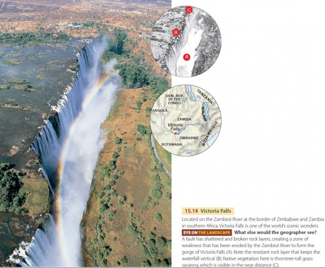
Large waterfalls are comparatively rare the world over, since the stream gradation process drains lakes and removes falls and rapids. But when tectonic activity fractures and dislocates crustal blocks, erosion may be hard pressed to keep up. As a result, we see great waterfalls on several large rivers in the African Rift Valley region. One of these is Victoria Falls, on the Zambezi River, shown in Figure 15.14.
Another class of large waterfalls involves new river channels resulting from glacial activity in the Ice Age. Large moving ice sheets eroded and deposited sediment, creating lakes and shifting river courses in northern continental regions. Niagara Falls is a prime example. The outlet from Lake Erie into Lake Ontario, the Niagara River, runs over a gently inclined layer of limestone, beneath which lies easily eroded shale. The river has gradually eroded the edge of the limestone layer, producing a steep gorge marked by Niagara Falls at its head. The Niagara Power project uses the falls' 52-m (171-ft) drop to generate hydroelectric power. Water is withdrawn upstream from the falls and is carried in tunnels to generating plants located about 6 km (4 mi) downstream from the falls.
AGGRADATION AND ALLUVIAL TERRACES
Graded streams are delicately adjusted to their supply of water and rock waste from upstream sources. So they are highly sensitive to any changes in those inputs. Changes in climate or vegetation cover affect the discharge and stream load at downstream points, and these changes in turn require channel readjustments. One such change is the buildup of alluvium in valley floors.
Picture a stream transporting sediment. What happens if the bed load increases beyond the transporting capacity of the stream? The coarse sediment will start to accumulate along the section of channel where the excess load was introduced. These deposits of sand, gravel, and pebbles will raise the elevation of the streambed, a process called aggradation. As more bed materials accumulate, the stream channel gradient steepens and the flow speeds up. This velocity increase makes it easier for the stream to drag bed materials downstream, spreading them over the channel floor at more and more distant downstream sections. In this way, sediment introduced at the head of a stream will gradually spread along the whole length of the stream.
Aggradation changes the channel cross section from a narrow and deep form to a wide and shallow one. The new sediment deposits encourage the flow to divide into multiple threads, which rejoin and subdivide repeatedly to create a braided stream. The coarse channel deposits spread across the former floodplain, burying fine-textured alluvium under the coarse material. What causes stream load to increase, creating aggradation? One cause is accelerated soil erosion. Other causes are related to major changes in global climate, such as the onset of an ice age of glaciers that provide meltwater and sediment at their ends.
When stream load decreases, the braiding channel disappears. The stream begins to pick up sediment from the bed and banks and deepen its channel. The result is the formation of meanders and alluvial terraces, shown in Figure 15.17. The case shown could represent any one of a large number of valleys in New England or the Midwest.
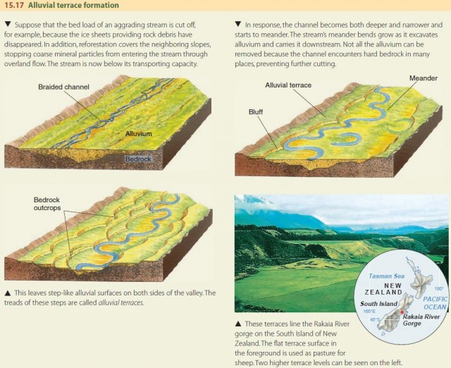
Alluvial terraces attract human settlement because—unlike valley-bottom floodplains—they aren't subject to annual flooding, and they are easier to cultivate than hillslopes, which can be steep and rocky. Terraces are easily tilled and make prime agricultural land. Towns, roads, and railroads are also easily laid out on the flat ground of a terrace.
ALLUVIAL RIVERS AND THEIR FLOODPLAINS
Now let's examine the floodplain of a graded river. As time passes, the floodplain is widened, so that broad areas of floodplain lie on both sides of the river channel. Civil engineers have given the name alluvial river to a large river of very low channel gradient. It flows on a thick floodplain of alluvium constructed by the river itself in earlier stages of its activity. An alluvial river in a humid environment normally experiences overbank floods each year or two.
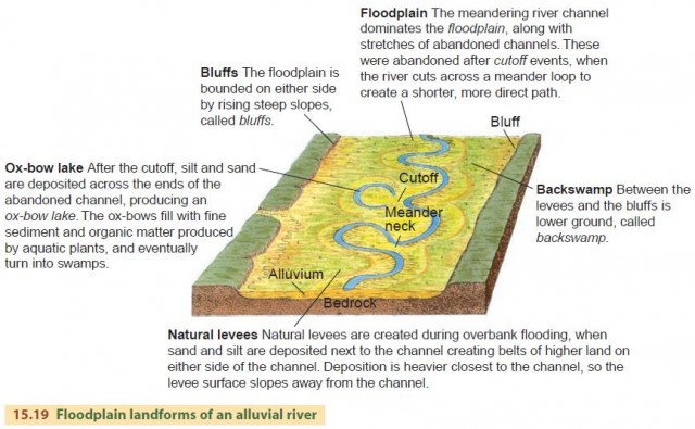
Figure 15.19 illustrates the typical landforms of an alluvial river and its floodplain, including bluffs, ox-bow lakes, natural levees, and backswamps. Bluffs are cut when meanders excavate older terraces or preexisting materials. Ox-bow lakes remain when meanders are cut off. When the floodplain is inundated, sand and silt are deposited in a zone next to the channel, creating natural levees. These flanks of high ground along the channel are normally the sites of towns and villages. Between the levees and the bluffs is lower ground, called the backswamp, which is subject to frequent flooding. It is best suited to agriculture, as regular overbank flooding of the backswamp provides a new layer of silt and infuses the soil with dissolved minerals. The resupply of nutrients helps floodplain soils retain their remarkable fertility, even though they may be located in regions of rainfall surplus from which these nutrients are normally leached away.
ENTRENCHED MEANDERS
What happens when a broadly meandering river is uplifted by rapid tectonic activity? The uplift increases the river's gradient, and in turn, its velocity, so that it cuts downward into the bedrock below. This forms a steep-walled inner gorge. On either side of the gorge there will be the former floodplain, now a flat terrace high above river level. Any river deposits left on the terrace are rapidly stripped off by runoff because floods no longer reach the terraces to restore eroded sediment.
The meanders become impressed into the bedrock, passing on their meandering pattern to the inner gorge. We call these sinuous bends entrenched meanders to distinguish them from the floodplain meanders of an alluvial river. Although entrenched meanders are not free to shift about as floodplain meanders do, they can slowly enlarge, producing cutoffs that can leave a high, round hill separated from the valley wall by the deep abandoned river channel and the shortened river course. As you might guess, such hills formed ideal natural fortifications. Many European fortresses of the Middle Ages were built on such cutoff meander spurs. Occasionally, if the bedrock includes a strong, massive sandstone formation, the meander cutoff can leave a natural bridge formed by the narrow meander neck.
FLUVIAL PROCESSES IN AN ARID CLIMATE
Desert regions look strikingly different from humid regions in both vegetation and landforms. Obviously, the lower precipitation makes the difference. Vegetation is sparse or absent, and land surfaces are mantled with mineral material—sand, gravel, rock fragments, or bedrock itself.
Although deserts have low precipitation, rain falls in dry climates as well as in moist, and most landforms of desert regions are formed by running water. A particular locality in a dry desert may experience heavy rain only once in several years. But when rain does fall, stream channels carry water and perform important work as agents of erosion, transportation, and deposition. Fluvial processes are especially effective in shaping desert landforms because of the sparse vegetation cover.
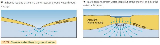
The few small plants that survive offer little or no protection to soil or bedrock. Without a thick vegetative cover to protect the ground and hold back the swift downslope flow of water, large quantities of coarse rock debris are swept into the streams. A dry channel is transformed in a few minutes into a flash flood of muddy water heavily charged with rock fragments. Water enters and leaves a stream channel differently in arid climates than in humid climates (Figure 15.22). In a humid region, the high water table slopes toward a stream channel, and ground water seeps into the streambed, producing permanent (perennial) streams. In arid regions, the water table lies far below the channel floor. Where a stream flows across a plain of gravel and sand, water is lost from the channel by seepage. As a result, aggradation occurs and braided channels are common. Streams of desert regions are often short and end in alluvial deposits or on the floors of shallow, dry lakes.
ALLUVIAL FANS
One very common landform built by braided, aggrading streams is the alluvial fan. This is a low cone of alluvial sands and gravels resembling an open fan. The central point of the fan lies at the mouth of a canyon or ravine. The fan is built out on an adjacent plain. Alluvial fans are of many sizes. Some desert fans are many kilometers across.
Fans are built by streams carrying heavy loads of coarse rock waste from a mountain or an upland region. The braided channel shifts constantly, but its position is firmly fixed at the canyon mouth. The lower part of the channel, below the apex, sweeps back and forth—accounting for the fan form and the downward slope in all radial directions away from the apex.
Alluvial fans are primary sites of ground water reservoirs in the southwestern United States. In many fan areas, we have rapidly lowered the water table by pumping for irrigation. It will take an extremely long time to recharge these ground water reserves from precipitation. One serious side effect of removing too much ground water is subsidence.
THE LANDSCAPE OF MOUNTAINOUS DESERTS
Where tectonic activity has recently produced block faulting in an area of continental desert, the assemblage of fluvial landforms is particularly diverse and interesting. The basin-and-range region of the western United States, which includes large parts of Nevada and Utah, southeastern California, southern Arizona, and New Mexico, is an example.
these mountainous deserts. The initial uplift creates two uplifted fault blocks with a downdropped block between them. Although denudation acts on the uplifted blocks as they are being raised, we have shown them as very little modified at the time tectonic activity has ceased. At first, the faces of the fault block are extremely steep. They are scored with deep ravines, and talus blocks form cones at the bases of the blocks.
At a later stage of erosion, streams have carved the mountain blocks into a rugged landscape of deep canyons and high divides. Rock waste from these steep mountain slopes is carried from the mouths of canyons to form large alluvial fans. The fan deposits form a continuous apron extending far out into the basins.
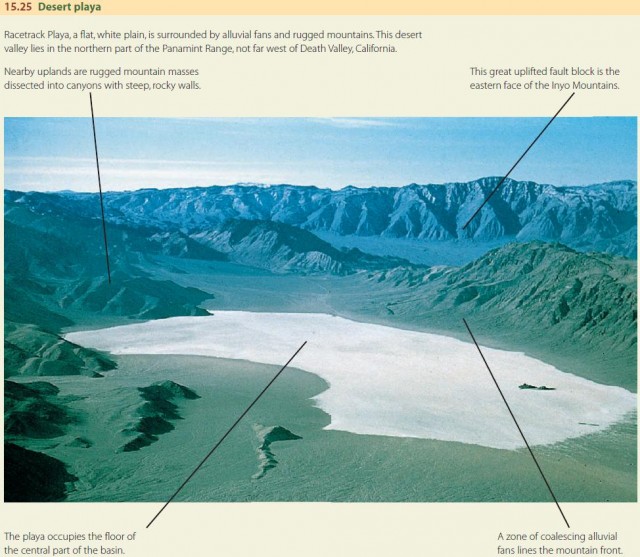
In the center of the desert basin is a dry lakebed, or playa, where fine sediments and precipitated salts produce a flat basin floor. In some playas, shallow water forms a salt lake. Figure 15.25 is an air photograph of a mountainous desert landscape showing many of these features.
A gently sloping rock surface, thinly veneered with alluvium, sometimes stretches from the mountain flank toward the playa. This surface—a pediment—may be an ancient low-angle fault plane; an old surface created by many years of weathering during a wetter climate; or a surface formed by retreat of the mountain front.
THE GEOGRAPHIC CYCLE
The Earth's fluvial landscapes are quite diverse. They range from mountain regions of steep slopes and rugged peaks to regions of gentle hills and valleys, to nearly flat plains that stretch from horizon to horizon. We can think of these constantly changing landscapes as stages of evolution in a cycle that begins with rapid uplift by plate tectonic activity and follows with long erosion by streams in a graded condition. This cycle, called the geographic cycle, was first described by William Morris Davis, a prominent geographer and geomorphologist of the late nineteenth and early twentieth centuries.
In Davis's model, the landscape begins at a youthful stage of steep slopes and river channels. In the mature stage, hills are rounded and slopes are gentler. In old age, the landscape is an undulating surface drained by slow and sluggish streams. With rapid uplift, rejuvenation occurs and the cycle begins anew.
EQUILIBRIUM APPROACH TO LANDFORMS
Davis's idealized geographic cycle is useful for understanding landscape evolution over very long periods of time, but it does little to explain the diversity of the features observed in real landscapes. Most geomorphologists think of landforms and landscapes in terms of equilibrium. This approach explains a fluvial landform as the product of forces acting on it, including both forces of uplift and denudation activities that wear down rocks.
One strength of this viewpoint is that we can take into account the characteristics of the rock material. Thus, we find steep slopes and high relief where the underlying rock is strong and highly resistant to erosion. Even a “youthful” landscape may be in a long-lived equilibrium state in which hillslopes and stream gradients remain steep in order to maintain a graded condition while eroding a strong rock like massive granite.
Another problem with Davis's geographic cycle is that it only applies where the land surface is stable over long periods of time. But we know from our study of plate tectonics that crustal movements are frequent on the geologic time scale. Few regions of the land surface remain untouched by tectonic forces in the long run. Recall also that continental lithosphere floats on a soft asthenosphere. As layer upon layer of rock is stripped from a land mass by erosion, the land mass becomes lighter and is buoyed upward. A better model, then, is one of uplift as an ongoing process to which erosional processes are constantly adjusting rather than as a sudden event followed by denudation.