Geographic Information Systems
Maps, like books, are very useful devices for storing information, but they have limitations. Recent advances in computing capability have enabled geographers to develop a powerful new tool to work with spatial data—the geographic information system (GIS). A GIS is a computer-based system for acquiring, processing, storing, querying, creating, analyzing, and displaying spatial data. Geographic information systems have allowed geographers, geologists, geophysicists, ecologists, planners, landscape architects, and others to develop applications of spatial data processing ranging from planning land subdivisions on the fringes of suburbia to monitoring the deforestation of the Amazon Basin.
SPATIAL OBJECTS IN GEOGRAPHIC INFORMATION SYSTEMS
Geographic information systems are designed to manipulate spatial objects. A spatial object is a geographic point, line, or area to which some information is attached. This information may be as simple as a place name or as complicated as a large data table with many types of information. Some spatial objects are illustrated in Figure I.16.
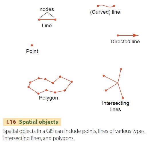
A point is a spatial object without an area, only a location. A line is also a spatial object with no area, but it has two points associated with it, one for each end of the line. These special points are often referred to as nodes. Normally a line is straight, but it can also be defined as a smooth curve having a certain shape. If the two nodes marking the ends of the line are differentiated as starting and ending, then the line has a direction. If the line has a direction, then its two sides can be distinguished. This allows information to be attached to each side—for example, labels for land on one side and water on the other. Lines connect to other lines when they share a common node. A series of connected lines that form a closed chain is a polygon. A polygon identifies an area, the last type of spatial object.
By defining spatial objects in this way, computer-based geographic information systems allow easy manipulation of the objects and permit many different types of operations to compare objects and generate new objects. As an example, suppose we have a GIS data layer composed of conservation land in a region represented as polygons and another layer containing the location of preexisting water wells as points within the region (Figure I.17). It is very simple to use the GIS to identify the wells that are on conservation land. Or the conservation polygons containing wells may also be identified and even output as a new data layer.
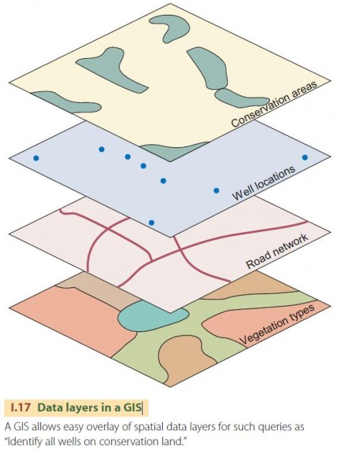
By comparing the conservation layer with a road network layer portrayed as a series of lines, we could identify the conservation polygons containing roads. We could also compare the conservation layer to a layer of polygons showing vegetation type, and tabulate the amount of conservation land in forest, grassland, brush, and so forth. We could even calculate distance zones around a spatial object, for example, to create a map of buffer zones that are located within, say, 100 meters of conservation land. Many other possible manipulations exist.
KEY ELEMENTS OF A GIS
A geographic information system consists of five elements: data acquisition, preprocessing, data management, data manipulation and analysis, and product generation. Each is a component or process needed to ensure the functioning of the system as a whole. In the data acquisition process, data are gathered together for the particular application. These may include maps, air photos, tabular data, and other forms as well. In preprocessing, the assembled spatial data are converted to forms that can be ingested by the GIS to produce data layers of spatial objects and their associated information.
The data management component creates, stores, retrieves, and modifies data layers and spatial objects. It is essential to proper functioning of all parts of the GIS. The manipulation and analysis component is the real workhorse of the GIS. Utilizing this component, the user asks and answers questions about spatial data and creates new data layers of derived information. The last component of the GIS, product generation, produces output products in the form of maps, graphics, tabulations, or statistical reports that are the end products desired by the users. Taken together, these components provide a system that can serve many geographic applications at many scales.
Many new and exciting areas of geographic research are associated with geographic information systems, ranging from development of new ways to manipulate spatial data to the modeling of spatial processes using a GIS. An especially interesting area is understanding how outputs are affected by errors and uncertainty in spatial data inputs, and how to communicate this information effectively to users.
Geographic information systems is a rapidly growing field of geographic research and application. Given the rate at which computers become ever more powerful as technology improves, we can expect great strides in this field in future years.