How Do We Depict Earth’s Surface?
EARTH'S SURFACE DISPLAYS various features, including mountains, hillslopes, and river valleys. We commonly represent such features on the land surface of an area with a topographic map or shaded-relief map, each of which is useful for certain purposes. Some maps allow us to visualize the landscape and navigate across the land, whereas others permit the quantitative measurement of areas, directions, and steepness of slopes.
How Do Maps Help Us Study Earth's Surface?
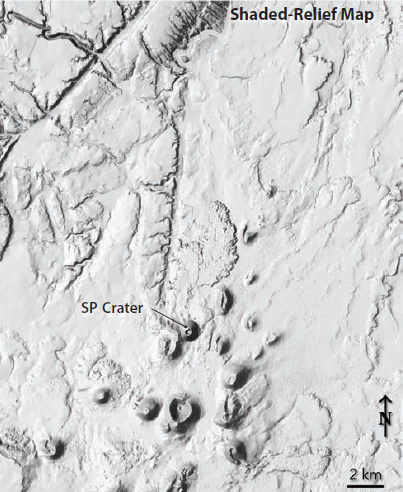
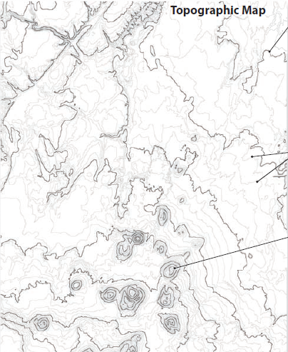
Maps are the primary way we portray the land surface. Some maps depict the shape and elevation of the land surface, whereas others, like a soil map, represent the materials on that surface. Views and maps of SP Crater in northern Arizona provide a particularly clear example of the relationship between the land surface and different types of maps.
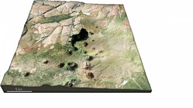
- This perspective view has aerial photography superimposed over topography (shape of the land). What features do you observe in the topography? Which areas are high in elevation? What are the most distinctive features?
- The area has distinct, cone-shaped hills surrounded by broad, less steep areas. The hills are small volcanoes, which form when fragments of molten rock are ejected into the air and settle around a volcanic vent.
- In the center of the area is a nearly black feature, which is a solidified lava flow formed when fluid magma erupted onto the surface in the last 5,000 years. The volcano at the southern end of the lava flow is named SP Crater, and is well known to many physical geographers.
- Examine other features in the scene. Note the light-gray areas in the upper left parts of the image, and the linear features that cut across the gray rocks. Different materials are forming different types of landscapes. This entire area has a relatively dry climate, with few trees to obscure the landform features.
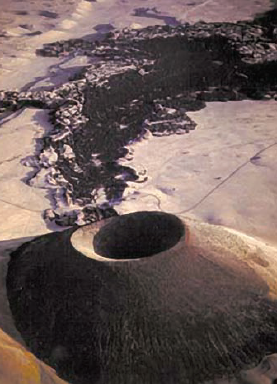
This aerial photograph shows SP Crater and the dark lava flow that erupted from the base of the volcano. Note that the slopes of the volcano are much steeper than those of the surrounding land.
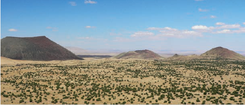
This photograph, taken from the large crater south of SP Crater, shows the crater (on the left) and several other volcanoes. The view is toward the north. Try to match some of the features in this photograph with those shown in the larger perspective view. In starting such activities, it is always best to begin with a known feature (in this case SP Crater).
A shaded-relief map emphasizes the shape of the land by simulating light and dark shading on the hills and valleys. The individual hills on this map are volcanoes. The area is cut by straight and curving stream valleys that appear as gouges in the landscape. Simulated light comes from the upper left corner of the image.
A topographic map shows the elevation of the land surface with a series of lines called contours. Each contour line follows a specific elevation on the surface. Standard shaded-relief maps and topographic maps depict the shape of the land surface but give no specific and direct information about what lies beneath.
How Do We Refer to Differences in Topography?
Earth's surface is not flat and featureless, but instead has high and low parts. Topography is steep in some areas but nearly flat in others. We use common terms to refer to the height of the land and the steepness of slopes.
Elevation, Depth, and Relief
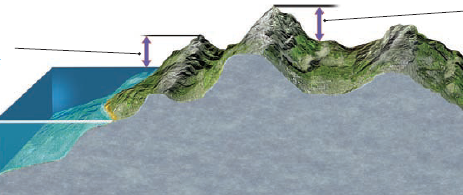
1. The height of a feature above sea level is its elevation. Scientists describe elevation in meters or kilometers above sea level, but some maps and most signs in the U.S. list elevation in feet.
2. Beneath water, we talk about depth, generally expressing it as depth below sea level. We use meters for shallow depths and kilometers for greater ones.
3. We also refer to the height of a feature above an adjacent valley. The difference in elevation of one feature relative to another is topographic relief. Like elevation, we measure relief in meters or feet; we refer to rugged areas as having high relief and to flatter areas as having low relief.
Slope and Gradient
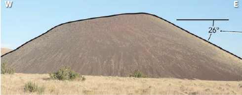
4. One way to represent the topography of an area, especially the steepness of the land surface, is to envision an imaginary slice through a terrain, like this one through SP Crater. The dark line shows the change in elevation across the land surface, and is a topographic profile. Cliffs and slopes that drop sharply in elevation are steep slopes, whereas topography that is less steep is referred to as being gentle, as in a gentle slope.
5. We describe steepness of a slope in degrees from horizontal. The eastern slope of SP Crater has a 26-degree slope (26° slope). We also talk about gradient—a 26° slope drops 480 meters over a distance of one kilometer, typically expressed as 480 m / 1,000 m or simply as 0.48.