How Do We Evaluate Sites for Solar-Energy Generation?
SOLAR ENERGY IS A RENEWABLE SOURCE of light, heat, and electricity. Solar energy is typically collected with a solar panel, which can generate electricity or can heat air, water, or some other fluid. You have an opportunity to evaluate the solar-energy potential of five sites in South America, using concepts you have learned about insolation in this chapter. To do this, you will use zenith angles at each site to determine how directly sunlight will strike solar panels at different times of the year. You will then consider some regional factors that influence how much insolation reaches the ground. From these data, assess how efficient each site will be at generating solar energy.
Goals of This Exercise:
- Understand the importance of latitude in constraining the maximum possible amount of insolation striking the surface, to help evaluate the solar energy potential of a site.
- Use factors controlling regional amounts of insolation, along with characteristics of the geographic setting of a site, to evaluate how much insolation is likely to actually arrive at Earth's surface, the key factor in the solar-energy potential of each site.
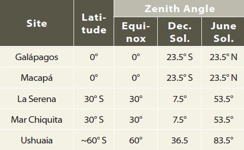
1. The globe below is a view centered on the continent of South America, and it shows the South Pole and adjacent parts of the Southern Hemisphere. It locates five possible sites you will consider for their solar energy potential: (1) the Gal?pagos Islands, part of the country of Ecuador; (2) Macap?, a small settlement in Brazil; (3) La Serena, a coastal town of Chile; (4) near Mar Chiquita, in central Argentina, and (5) Ushuaia, the capital of the Tierra del Fuego Province of southernmost Argentina. Some characteristics of each site are described below.
2. The Gal?pagos are a series of islands in the Pacific Ocean, far west of South America. They are known for their exotic animal species, made famous by the visits of Charles Darwin. Although surrounded by the ocean, many parts of the islands receive little rain and are similar to a desert.
3. La Serena is a popular tourist site along the Pacific coast of Chile. It has a cool, desert climate, caused in part by a cold ocean current (the Humboldt Current) that limits the amount of moisture in the air. It is on the fringe of the Atacama Desert, the driest place on Earth (the tan strip along the coast to the north of 30° S on the globe).
4. Ushuaia, the southernmost city in the world, is near Cape Horn, the southern tip of South America. Cape Horn is surrounded on three sides by ocean, some of which is coming from near Antarctica and is very cold. As a result, Ushuaia has a relatively cold and humid climate. It is close to 55° S latitude, but for this exercise we will consider it to be at 60° S to simplify our calculations.
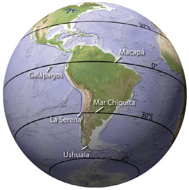
5. Mar Chiquita is a small inland lake on the plains of central Argentina, far from the oceans but at a relatively low elevation. The proposed site is north of the lake, far enough that the lake does not significantly affect the local climate. This part of Argentina is east of the Andes, the huge mountain range along the western coast of South America. The Andes block moisture from the west, causing the plains of Argentina to be relatively dry.
6. Macap? is a small community in Brazil, near the mouth of the Amazon River, just inland from the sea. It is next to the Amazon River, the world's largest river, and is part of the huge Amazon rain forest, which stretches from the Atlantic Ocean westward all the way to the foothills of the Andes. As part of the rain forest, Macap? is a humid, rainy place.
7. From the latitude of each site we can calculate the zenith angle at each site for an equinox and both solstices. These results are presented in the table above.
Procedures
- Read descriptions of each site and consider how the geographic setting might impact the favorability of the site for solar-energy production.
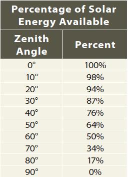
- For each site, use the zenith angles to look up the maximum percentage of solar energy that is theoretically available.
- Use a graph of insolation as a function of latitude and month to evaluate how the maximum amount of insolation for each site varies during the year.
- List the pros and cons of building a solar-energy facility at each site.
- OPTIONAL EXERCISE: Your instructor may provide you with simple formulas for calculating zenith angle from latitude and have you determine zenith angles and solar favorability for other sites, some near where you live.
8. In considering the various sites, an important factor is that the solar panel will be horizontal. So we can use zenith angle as a measure of whether the sunlight is coming in perpendicular to the solar panel, the optimum orientation. Although this orientation works fine near the equator, at other latitudes solar panels are inclined at some other angle so as to maximize the amount of sunlight (keeping the panel perpendicular to the direction of
sunlight, wherever possible).
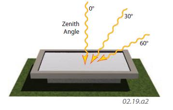
9. Use the zenith angle for each site to determine the maximum percentage of energy that can be produced by the solar panel for that zenith angle, relative to the maximum amount it could produce if it were perfectly perpendicular to the Sun. Write down your results to guide your considerations in evaluating each site.
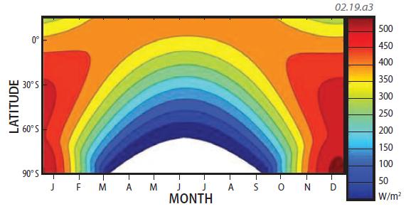
10. Use this graph to estimate the quantity of insolation arriving at the top of the atmosphere above each location, during the months of the solstices (December and June) and the equinoxes (March and September). The graph is in W/m2. During which month does each site theoretically (ignoring atmospheric effects) receive the most and the least insolation? Which site or sites receive the most and the least insolation overall? Record your results.
11. Since the numbers on this graph represent the amount of insolation reaching the top of the atmosphere, we must now consider how the climate of each site might decrease this amount, such as from excessive cloudiness. Use the globes below to complete this step. Finally, combine your zenith calculations with results from the graph to the left and the globes below to make a list showing the pros and cons of each site. Choose the best site and be able to defend your conclusions.
Downward Shortwave Radiation Flux This globe shows the amount of shortwave radiation (insolation) that actually reaches the surface. Red, orange, and yellow show higher amounts of insolation reaching the surface, whereas blue and purple show low amounts. The generally higher amounts of insolation in the tropics versus the low amounts near the South Pole show the effects of latitude. The deviations from the broad pattern, such as the green low over the Amazon, are due to processes in the atmosphere that reflect, absorb, or scatter insolation. Use what you know about the geographic setting of each site to propose what processes explain the pattern on this globe.
Outgoing Longwave Radiation Flux (OLR) This globe shows the amount of OLR emitted by Earth's surface. Such radiation is not useful for generating solar energy because it is longwave and, therefore, less energetic than shortwave, and because it is going upward, not down. It is a useful indication, however, of processes going on in the atmosphere because it suggests, for example, the abundance of water vapor (a greenhouse gas) and clouds, which can absorb longwave radiation before it exits the atmosphere, thereby reducing OLR. On this globe, orange represents high amounts of OLR, whereas purple and blue represent much smaller amounts. What do the patterns indicate, and what are the implications of both globes for solar energy?
- How Are Variations in Insolation Expressed Between the North and South Poles?
- Why Do Temperatures Vary Between Oceans and Continents?
- How Do Insolation and Outgoing Radiation Vary Spatially?