Junngar Basin
THE JUNNGAR BASIN (also Dzungar) is one of the two major basins that make up much of northwestern CHINA's XINJIANG province (Xinjiang Uygur Autonomous Region). The basin, covering some 69,500 square mi (180,000 square km), is located to the north of the TIAN SHAN MOUNTAINS and has a mixed landscape that includes mountains, deserts, steppes, salt lakes and swamps. The region has much the same pattern as the TARIM BASIN, which is located to the south of the Tian Shan. However, because the Junngar is approximately 1,968 ft (600 meters) lower than the Tarim Basin, it is not quite as arid, receiving between 4 to 12 in (10 to 30 cm) of precipitation per year. In addition, there is also much greater snowfall and snow cover during the winter season, which helps increase the growth of natural vegetation.
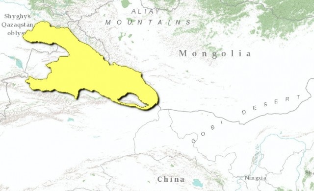
The basin is triangular in shape, with the towering Tian Shan Mountains to the south, the Altai Mountains along the border with MONGOLIA to the northeast, and the Ala Tau Mountains along the border with RUSSIA and KAZAKHSTAN in the northwest. The Junngarian Gate, a rift valley in the Ala Tau Mountains, provides an outlet from the Junngar Plain to Lake Balkhash and Kazakhstan to the northwest. The gate is famous for its roaring winds that blow for more than 150 days per year. Between the sand desert at the basin's core and the gravel GOBI is a narrow plain often referred to as the “spring line,” where the soil has some clay and silt, allowing limited agriculture and human settlement.
The basin is somewhat geographically cut off from CHINA proper. It is possible to travel over a pass between the Bogdo Ula and the Tian Shan at 3,600 meters high and descend into the Turfan area on the south. Otherwise, the route to China leads through some very desolate valleys parallel to the Altai Mountains in the east to the Mongolian Gobi. Because the slope of the area is to the west, all of the major rivers flow east to west. The upper waters of the Irtysh River, the only river in China that flows to the Arctic Ocean, provides access to Zaisan Nor and Semipalatinsk in Russia. The two main rivers flowing within the basin are the Manas and the Urungu.
These, together with numerous streams descend to the plains before being lost in the reedy marshes and sands of the basin proper. The high mountain ranges surrounding the basin receive as much as 30 in (75 cm) of precipitation a year. The Altai Mountains are notably forested, and the lower slopes covered with willows, poplars, alders, and white birch as you move higher. Above about 6,000 ft (1,800 m), the Siberian larch is dominant, with many of the trees more than 98 ft (30 m) in height. Given this heavy forest cover, the mountain areas bordering the basin are rich in furbearing animals such as fox, wolf, sable, ermine, bear, and wolverine.
In contrast to the Tarim Basin, where there are extensive desert lands between oases, the Junngar has a STEPPE and steppe-DESERT landscape with some natural vegetation in the wide valleys that border the central desert lands. Thus, nomadic pastoralism is practiced here as the dominant way of life. Because annual rainfall is typically less than 10 in (25 cm), the pastoralists must be constantly on the move in search of fresh grass. This is much different than in the Tarim Basin to the south of the Tian Shan, where human activity is oasis oriented and people move in trade-oriented patterns from oasis to oasis.
Despite the limited rainfall and desert conditions, major land reclamation projects have been undertaken to introduce arable farming to the region. About half of the reclaimed land is under cotton production, with the rest in rice, wheat, corn, soybeans, various fruits, and sugar beets. However, more recent economic interest has centered on the discovery of oil at Karamai. Following the discovery of coal and iron deposits on the north side of the Tian Shan, there has been rather rapid industrial development over the past decades.
Urumchi, the capital of Xinjian Province, is located on the southern edge of the basin on a high desert plateau. Before 1949, it was a quiet market town of less than 60,000 people. But with the discovery of oil, coal, iron and significant gold deposits, the city has grown to more than 1.75 million. It is also a center for iron and steel, textiles, and fertilizer production. The other interesting area in Junngaria is the Ili Valley. Lying north of the Tian Shan, but cut off from the rest of the basin, the valley flows westward to Lake BALKHASH in Kazakhstan. Because of the westward opening, the area is open to influence by more western climate characteristics, giving the area a special quality that supports arable farming and permanent settlements. The valley's high production of wheat and other grains has earned it the title of “the granary of Xinjiang.”