Kamchatka Peninsula
RUSSIA'S FAR EAST IS MARKED by the large mountainous peninsula known as Kamchatka. Kamchatka peaks form one of the most volcanically active regions on earth, counting over thirty active cones, and at least a hundred more that are now inactive. Few people live in this remote corner of Asiatic Russia, where ties to central government, or any government at all, have traditionally been weak at best.
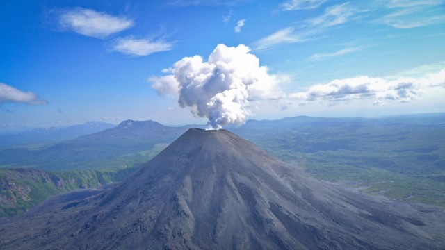
The Kamchatka Peninsula, 750 mi (1,200 km) in length, is formed of two parallel ridges of mountains, the northern extension of the Pacific RING OF FIRE, a continuation of a line of volcanoes stretching south across the Kuril Islands to the ranges of HOKKAIDO, JAPAN. The western range is older, and forms the central spine of the peninsula. The eastern range was formed more recently and contains most of the active volcanoes, notably in the Kluchevskaya Complex, where twelve cones create a plateau of ash and hardened lava that so resembles the landscape of the moon that it has been used as a testing site for Soviet lunar vehicles. Kluchevskaya Sopka, at 15,584 ft (4,750 m), is the tallest volcano in Eurasia.
This intensely active region—bubbling with mud pools, geysers, sulfur springs and fumaroles—is caused by the collision of the Pacific and Eurasian plates of the earth's crust, plus the jointure with another active tectonic fault that runs from here to the east, forming Alaska's ALEUTIAN ISLANDS.
Kamchatka is joined to the mainland of Russia by a narrow isthmus, approximately 60 mi (110 km) wide. To the north lies the Koryak Plateau and the Chukchi Autonomous Republic, the land of Russia's Arctic nomads, similar to Alaskan natives. Kamchatka itself is populated partially by indigenous Koryak tribes, and by Russians. Its population of roughly 250,000 live mostly in the regional capital, Petropavlovsk-Kamchatskiy, or in small coastal settlements. The eastern coastline borders the PACIFIC ocean and its subsidiary, the Bering Sea, and is roughly indented with bays and steep inclines resulting from the presence of the eastern mountain chain and individual volcanoes. The western coast is, by contrast, smooth and low in elevation, with numerous swamps, tallgrass meadows, and swift rivers. The largest river, the Kamchatka, is not on this plain but runs south to north between the western and eastern ranges before turning east to empty into the Pacific at the peninsula's only other city of significance, Ust' Kamchatsk.
Russian expansion to the Pacific was checked in the mid-17th century along the AMUR RIVER by the Chinese, so trappers, merchants and adventurers turned further north and crossed the Sea of Okhotsk to reach Kamchatka in the early years of the 18th century. The city of Saints Peter and Paul, Petropavlovsk, was built in 1740, designed to be a springboard for imperialist ambitions in Japan, CHINA, and even INDIA. Instead, the settlements here became a launch-pad for exploration of Alaska and the northwest coast of North America. Russian occupation was brutal, sparking off a series of mass suicides among the Koryaks and Kamchadals, who preferred death to slavery, until administrators were finally sent from the imperial government to establish some sort of law and order.
By the mid-19th century, Russian interests were again looking south to China and the rich Amur Valley, so Kamchatka faded in importance. American and British whalers, however, continued to trade regularly with Russian Far East settlements. Japanese fishing fleets also came in large numbers, attracted to the vast numbers of salmon, red roe, and other fish in Kamchatka's waters. Trade with Americans and Japanese was encouraged during the 1930s (a formality, since Moscow's central authority was so far away anyway) but was sharply curtailed after World War II, when the area became one of the most completely sealed-off regions in the entire Soviet Union. One of the primary focuses during this time was the creation of geothermal power stations, several of which are now under sharp scrutiny for environmental violations. Other resources—coal, copper, gold, iron and sulfur—are still mostly unexploited because of great distances from commercial markets, and extreme harshness of the climate. Kamchatka has formed its own separate district since 1956 (178,746 square km or 69,711 square mi), but the Koryak area to the north declared itself independent in 1990.