Pleistocene geography
THE PLEISTOCENE EPOCH was Earth's most recent Ice Age. The epoch began around 1.8 million years ago (mya) or 2.6 mya. Traditionally, scientists have based the starting date of the epoch on faunal grounds and have estimated it to be about 1.8 mya. A growing number of climate scientists and glaciologists tend to use 2.6 Mya, a time when there was a rapid buildup of ice in the Northern Hemisphere.
There is general agreement that the Pleistocene ended about 10,000 years ago, when temperatures similar to modern times became the norm. The geography of the Pleistocene is of great interest to us for the sheer magnitude of ice coverage, the epoch's wide swings in temperature, and its impacts on the land, people, and animals of the time. Additionally, Earth is presently in a warm, interglacial period, but climate scientists believe that in about 10,000 years or so we could be in the midst of another ice advance; thus, studying the Pleistocene helps us understand humankind's past and contemplate its future.
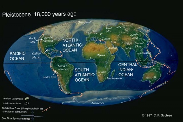
Climate scientists estimate that the Pleistocene ice sheets covered about 25 to 30 percent of today's land surface. The modern-day ice sheets—the eastern and western Antarctic ice sheets and the Greenland ice sheet—cover only 10 percent of the land. Six or seven ice sheets existed in the Northern Hemisphere 21,000 years ago, when the last glacial maximum occurred. By far the largest ice sheet, the Laurentide, stretched over east-central CANADA and part of the UNITED STATES. Another ice sheet, the Cordilleran, covered the northern Canadian islands, the Rockies of Canada, and parts of MONTANA and IDAHO in the United States. The Greenland ice sheet covered the island of GREENLAND.
The Britain ice sheet spread out over the islands of Britain and IRELAND. The Scandinavian ice sheet spread from NORWAY, SWEDEN, and FINLAND across most of the North European Plain and western RUSSIA. A sixth ice sheet, the Barents-Kara, overlapped north-central Eurasia's northern continental shelf and mainland. A seventh glacier—the East Siberian—might have existed separately from the Barents-Kara sheet. End moraines, glacial lake varves, and carbon-14 dating document where the southern edges of the ice sheets were. In contrast, the positions of the sheets' higher latitude margins are the subject of much scientific debate. The Laurentide and Cordilleran ice sheets may have fused together. The Britain, Scandinavian, and Barents-Kara ice sheets may have also joined.
In addition to Pleistocene ice sheets, mountain glaciers of that time were more numerous at lower latitudes than today. Large highland ice caps draped the summits of the ALPS, South Island of NEW ZEALAND, HIMALAYAS, southern ROCKY MOUNTAINS, and the southern and central ANDES. In addition, small alpine glaciers were more widespread in the tropics and middle latitudes than today.
The Pleistocene epoch's temperatures were cooler than now, but not uniformly so, as repeated episodes of interglacial warmth punctuated its history. Computer models tell us that during glacial advances, global average surface-water temperatures were 9 or more degrees F (5 degrees C) cooler than today. Air over the land was even cooler. For instance, average temperatures of North America were at least 14 degrees F (8 degrees C) cooler. Sea ice was extensive: It was possible to walk from the Brittany coast of FRANCE to IRELAND, for instance. In contrast, the southern limit of sea ice in the present interglacial period is just slightly south of Greenland. Sea ice was farther north in previous interglacials, as temperatures were 2 to 5 degrees F (1 to 3 degrees C) warmer than the present. The warmth of the Pleistocene interglacials resulted in higher evaporation rates and more intense monsoon winds areas than those of today. For instance, during the last Pleistocene interglacial period, stronger monsoon winds delivered significantly more rainfall to subtropical and middle latitude regions. As a result, large lakes, lush savanna grasses, and riparian woodlands covered areas that are now desert, such the SAHARA DESERT of northern Africa and the Mojave Desert of the U.S. southwest.
ERODED LANDSCAPES
Pleistocene glaciers left behind eroded landscapes in high latitude and alpine landscapes: thin soils, large exposures of ice-scoured rocks, countless lakes, and steep-walled fjords. Additionally, mountain glaciers created signature cirque basins, U-shaped valleys, narrow- crested aretes and steeple-sharp horns. Rubble of interlobate and end moraines chronicle the size and extent of the glaciers. Moreover, table-flat beds of proglacial lakes and outwash plains, abandoned meltwater channels, sinuous eskers, kames, kettles, and valley trains attest to the voluminous glacial melting that took place after the last glacial maximum.
The rising temperatures that ended the Pleistocene epoch shrank the arctic tundra and cold-tolerant coniferous forests. Simultaneously, there was a dramatic expansion in the boundaries of warmer climes—tropical rainforests, subtropical deserts, and middle latitude forests.
The end of the Pleistocene also witnessed the extinction of many cold-tolerant mammals: the mastodon, woolly mammoth, true horses, saber-toothed tigers, large wolves, giant armadillos, as well as giant ground sloths and ancient bisons, camels, and wild pigs. Biological and cultural evolutions of early human beings also took place during the Pleistocene. Humans' evolving intelligence, as well as hunting and gathering technology, enabled them to adapt to a rapidly changing environment and to spread to all the continents (except ANTARCTICA) before the Pleistocene epoch ended.