Processes and Landforms of Arctic and Alpine Tundra
The treeless arctic and alpine tundra environment is severely cold in winter. In the tundra, soil water is solidly frozen for many months. During the short summer season, however, the surface thaws, leaving the soil saturated and vulnerable to mass wasting and water erosion. With the return of cold temperatures, the freezing of soil water exerts a strong mechanical influence on the surface layer, creating a number of distinctive landforms. The tundra environment is a unique natural system because it is often found close to glacial ice, near tongue-like alpine glaciers, and along the fringes of ice sheets. We call this a periglacial environment (peri, meaning “near”).
PERMAFROST
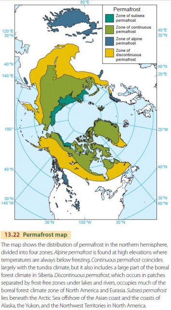
Ground and bedrock that lie below the freezing point of fresh water (0°C; 32°F) all year round are called permafrost. “Ground” includes clay, silt, sand, pebbles, and boulders. Solid bedrock permanently below freezing is also included in permafrost. Water is commonly found in pore spaces in the ground, and in its frozen state it is known as ground ice. Figure 13.22 is a map showing the distribution of permafrost in the northern hemisphere. Permafrost reaches to a depth of 300 to 450 m (about 1000 to 1500 ft) in the continuous zone near lat. 70° N. Much of this permanently frozen zone is inherited from the last Ice Age and will eventually thaw unless a glacial period returns.
Permafrost terrains have a shallow surface layer, known as the active layer, which thaws with the changing seasons. The active layer ranges in thickness from about 15 cm (6 in.) to about 4 m (13 ft), depending on the latitude and nature of the ground. It contains plant roots as well as the water and nutrients needed to support them. Below the active layer is the permafrost table, marking the upper surface of the permanently frozen zone.
GROUND ICE
The amount of ground ice present below the permafrost table varies greatly from place to place. At great depth, pores in the rock hold little if any frozen water. Near the surface, ground ice can take the form of a body of almost 100 percent ice, and lenses, wedges, veins, or thick, massive beds of ice are common.
A common form of ground ice is the ice wedge. Ice wedges form as ice accumulates in vertical wedges in deep cracks in the frozen ground. Ice wedges are typically interconnected into a system of polygons, called ice-wedge polygons. Another is the ice lens. At the end of the warm season, meltwater accumulates at the bottom of the active layer, on the permafrost table. It then freezes into a more-orless horizontal layer of ice that can grow and persist. Ice lenses form under other conditions as well.
Even in the areas of deepest continuous permafrost there are isolated pockets—called taliks—that never fall below the freezing point. Some of these pockets occur within permafrost as lenses of persistent unfrozen water. Others are large features underlying lakes and rivers. Water at the bottom of most lakes and flowing rivers, in spite of a winter ice cover, remains at or near 0°C, keeping the ground below these features unfrozen. The depth of the talik under a lake depends primarily on the width of the lake. Under a small lake, the talik may be bowl-shaped and extend downward some tens of meters.
Another remarkable ice-formed feature of the arctic tundra is a conspicuous conical mound, called a pingo. The pingo has an ice core and slowly grows in height as more ice accumulates, forcing the overlying sediments upward. In extreme cases, pingos reach heights of 50 m (164 ft), with a base diameter of 600 m (about 2000 ft).
ENVIRONMENTAL PROBLEMS OF PERMAFROST
Human activity degrades the permafrost environment by burning or scraping away layers of decaying matter and plants from the surface of the tundra or arctic forest. Because this surface layer has been removed, the summer thaw extends deeper into the ground, so ice wedges and other forms of ground ice melt in the summer and waste downward. Meltwater mixes with silt and clay to form mud, which is then eroded and transported by streams, leaving trench-like morasses. This total activity is called thermal erosion.
When the natural surface cover is removed over a large expanse of nearly flat arctic tundra, the ground can subside as the permafrost melts. Shallow depressions form, fill with water, and create shallow lakes. The lakes expand by thawing the permafrost at their margins, and soon a terrain of shallow lakes and bogs, called thermokarst, develops.
To avoid creating thermal erosion and thermokarst terrain, buildings on permafrost are placed on piles with an air space below or, alternatively, on a thick insulating pad of coarse gravel. Steam and hot- water lines are placed above ground to prevent thawing of the permafrost layer.
PATTERNED GROUND AND SOLIFLUCTION
Areas that contain coarse-textured regolith, consisting of rock fragments in a wide range of sizes, can give rise to some very beautiful and distinctive features. The annual cycle of thawing and freezing sorts the coarsest fragments—pebbles and cobbles—from finer particles by moving them horizontally and vertically. This sorting produces rings of coarse fragments. The rings are linked in a network, forming systems of stone polygons or stone nets. On steep slopes, soil creep elongates the polygons in the downslope direction, turning them into parallel stone stripes. Stone polygons and ice-wedge polygons are examples of patterned ground.
Solifluction is a special variety of earthflow in arctic permafrost tundra regions. It occurs in late summer, when the ice-rich layer at the bottom of the active layer thaws to form a plastic mud. Moving almost imperceptibly on the plastic layer, the saturated soil is deformed into solifluction terraces and solifluction lobes that give the tundra slope a stepped appearance.
ALPINE TUNDRA
Most of the periglacial processes and forms we've discussed for the low arctic tundra are also found in the high alpine tundra throughout high mountains of the middle and high latitudes. Here, steep mountainsides with large exposures of hard bedrock were strongly abraded by glacial ice. Patterned ground and solifluction terraces occupy relatively small valley floors where slopes are low and finer sediment tends to accumulate.
CLIMATE CHANGE IN THE ARCTIC
Climate change is expected to raise temperatures and bring more precipitation to much of the North American arctic region. Substantial warming has already occurred. Climate scientists predict that by the end of the century arctic temperatures will have risen by 4°C to 8°C (7.2°F to 14.4°F), and annual precipitation will increase by as much as 20 percent. What impact will this have on arctic and boreal environments?
First, the warm temperatures and increased precipitation will deepen the active layer over broad areas of permafrost. This will create more thermokarst terrain, as ice-rich layers of permafrost melt and subside. Roads and pipelines will be disrupted. The winter hunting season will become shorter, and the populations of mammals, fish, and sea birds will fluctuate, making it harder for native people to maintain their way of life.
The boreal forest will migrate poleward, carrying along the border between continuous and discontinuous permafrost as increased snowfall warms the ground under new forest. Discontinuous permafrost will be reduced at the southern boundary, and the isolated permafrost to the south will largely disappear. Warmer soil temperatures will increase the decay of soil organic matter, releasing CO2 and further boosting the warming. Forest productivity will decline from summer drought stress, increased disease and insect damage, and more frequent burns. In short, the arctic environment seems set for major changes.